
- elevation 7,142 ft (2,177 m) Basin area 6,387 km² Country United States of America | - elevation 4,557 ft (1,389 m) | |
 | ||
- right East Fork Beaver River, North Creek (Beaver River), Indian Creek (Beaver River), Cove Creek - location near Delta, Millard County | ||
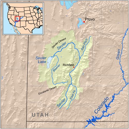
The Beaver River is a river in western Utah, 110 miles (180 km) long, that drains to Sevier Lake via the Sevier River.
Map of Beaver River, Utah, USA
The river starts in the Tushar Mountains, in eastern Beaver County near the town of Beaver, and flows for about 30 miles (48 km) west as a perennial stream, through the Beaver Valley to the Escalante Desert, where it turns north. The river then continues north for about 80 miles (130 km) as an ephemeral wash, past Milford into Millard County. Once it reaches the Sevier Desert south of Delta it turns west, joining the Sevier River and emptying into the intermittent, endorheic Sevier Lake.
The Beaver River watershed drains about 2,466 square miles (6,390 km2), most of it desert. The human population is about 3500, mostly concentrated in the town of Beaver. The river is dammed for irrigation in its upper reaches by Rocky Ford Dam, forming Minersville Reservoir. A total of 84,000 acres (34,000 ha) are farmed in the basin.