
- average 257 cu ft/s (7 m/s) Length 616 km Basin area 29,977 km² Country United States of America | - right East Fork, San Pitch - min 6 cu ft/s (0 m/s) Basin area 29,977 km² | |
 | ||
- max 5,400 cu ft/s (153 m/s) | ||
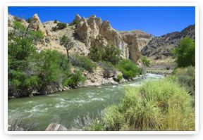
Fishing black canyon e f sevier river utah
The Sevier River /sɛˈvɪər/, extending 279 miles (449 km), is the longest Utah river entirely in the state and drains an extended chain of mountain farming valleys to the intermittent Sevier Lake. The Upper Sevier is used extensively for irrigation, and consequently Sevier Lake is now essentially dry.
Contents
- Fishing black canyon e f sevier river utah
- Map of Sevier River Utah USA
- Sevier river brown trout fishing
- CourseEdit
- HistoryEdit
- References
Map of Sevier River, Utah, USA
Sevier river brown trout fishing
CourseEdit
The Sevier River Water Users Association subdivides the river into four mainstream sections: Upper, Central, Gunnison and Lower.
Upper: The Sevier headwaters are in northwestern Kane County along the western side of the Paunsaugunt Plateau, and it flows northward into Garfield County through an extended valley beside the plateau past Hatch and Panguitch. Along the Garfield-Piute county line, the Sevier descends through the narrow 5 mi (8 km) Circleville Canyon, emerging into Circle Valley at Circleville. It then flows northeast towards Junction, where it receives the East Fork from the east and passes through the Piute Reservoir.
Central: It flows north across Piute County to Marysvale then descends through 8 mi (13 km) Sevier Canyon, emerging south of Sevier. It then flows northeast past Richfield and Salina.
Gunnison and Lower: After the San Pitch confluence and ~20 mi (32 km) southwest of Nephi, the river flows west around the north end of the Canyon Mountains into the Sevier Desert, then southwest past Delta and into Sevier Lake in central Millard County, along the western side of the Cricket Mountains. It is impounded in southeastern Juab County at the north end of the valley to form the 20-mi (32 km) long Sevier Bridge Reservoir. DMAD reservoir and Gunnison Bend reservoirs are near Delta with Sevier's water. DMAD water goes to the Intermountain Power Project's coal-fired plant located 9 miles west of US-6, north of Delta.
HistoryEdit
The Spanish Dominguez-Escalante Expedition crossed the river in 1776, as the missionaries passed through this area on their way to California.
The Old Spanish Trail trade route followed the Sevier River from Salina Creek to the southwest to the point north of Panguitch, where it left the river and crossed westward to what is now Parowan, Utah. It was heavily used from 1829 into the 1850s.
The upper portions of the river have been dammed and restricted for irrigation purposes, drawing off much of the water and leaving Sevier Lake essentially dry. In the 21st century, the Sevier River Water Users Association has installed solar-powered monitoring equipment, the Real-time Telemetry System, which reports on river flows, canal diversion flows, reservoir elevations and weather each hour. See http://www.SevierRiver.org.