
Primary inflows Max. width 1.1 km (0.68 mi) Area 7.23 km² | Primary outflows Saint Francis River Max. length 8.1 km (5.0 mi) Surface elevation 394 m Outflow location Saint Francis River | |
 | ||
Type Lake consisting of enlargement of the river Basin countries Canada, United States of America | ||
The Beau Lake (in French: "Le Beau Lac") is a freshwater lake in the north-south axis through the Saint Francis River (Canada–United States). The lake is the center of the boundary between:
Contents
Map of Beau Lake
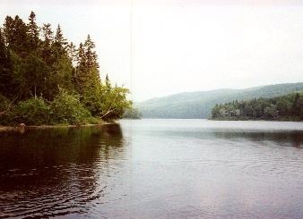
This lake is located entirely in the forest zone. In the story, the main economic activity was forestry. Since the mid-twentieth century, the resort and tourist activities have developed. This lake is particularly renowned for fishing and recreational boating in particular because of its mountainous landscape.
On the side of Maine, a forest road runs along the western shore of the lake. While the side of the Quebec, a few dozen homes are served by an access road to the northern half of the lake.
Geography
The lake is consisting of enlargement of the Saint Francis River (Canada–United States). This lake is walled by steep cliffs:
This lake is fed by the discharge of Saint Francis River (Canada–United States) (from the north) and the stream of "Coulée Creuse" (English: Creuse Casting) (from the east). This lake discharges through the South by the continuity of the Saint Francis River (Canada–United States).
The mouth of "The Beautiful Lake" is located at the bottom of the southern tip of the lake or at the limit of Quebec and New Brunswick.
Toponym
The place name "Le Beau Lac" was formalized on December 5, 1968 at the Commission de toponymie du Québec (Quebec Geographical Names Board).