
Population (2012) 232 Local time Tuesday 6:28 PM | Area 125.8 km² | |
 | ||
Intercommunality Community of communes of la Motte-Turriers Weather 3°C, Wind W at 13 km/h, 97% Humidity | ||
Bayons (Baion in Occitan) is a French commune in the Alpes-de-Haute-Provence department in the Provence-Alpes-Côte d'Azur region of south-eastern France.
Contents
- Map of 04250 Bayons France
- Geography
- Mapping
- Geology
- Relief
- Hydrography
- Environment
- Natural and technological risks
- Localities and hamlets
- Prehistory and Ancient times
- Astoin
- Bayons
- Esparron la Btie
- Reynier
- Modern times
- French Revolution
- Contemporary period
- Since World War II
- Municipal Administration
- Judicial and administrative proceedings
- Demography
- Overview
- Agriculture
- Labels
- Industry
- Service activities
- Cultural festivals
- Civil heritage
- Religious heritage
- References
Map of 04250 Bayons, France
The inhabitants of the commune are known as Bayonnais or Bayonnaises.
Geography
Bayons is located in the Massif des Monges some 20 km south by south-east of Gap and 15 km north-east of Sisteron. Access to the commune is by the D1 road from Clamensane in the west which passes through the commune and the village before continuing north to Turriers.
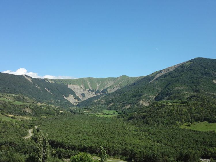
Bayons is situated in a vast Cirque surrounded by high mountains, through which the Sasse flows - exiting through a narrow clue. The commune was formed from the merger of four communes in 1973: Astoin, Bayons, Esparron-la-Bâtie and Reynier. Except for Astoin, the communes joined to Bayons in 1973 are located in parallel valleys perpendicular to the Sasse and downstream from Bayons. The commune is located in a region of mountainous relief and has a Mediterranean climate with challenging features (drought, irregular and heavy rains) as well as a mountain climate (cold with snow in winter). It is traversed by some tumultuous rivers. Agriculture in the area has always been difficult. The population of the four communes peaked in 1836 with 1625 inhabitants but a century and a half later, 90% of this population had been lost due to the rural exodus that began early and had more breadth in these four communes than in the rest of the department. This persuaded the government to propose the merger of the communes which took place on 1 April 1973. Since then the population has almost doubled: farms have been retained sometimes using regional quality labels. The communal economy is based on tourism but the majority of people in the commune work outside.
Mapping
A list of online mapping systems can be displayed by clicking on the coordinates (latitude and longitude) in the top right hand corner of this article.
Geology
Related article: Geology of the Alps.
The commune is located in the middle of three major geological Alpine formations:
During the last two major glaciations: the Riss glaciation and the Würm glaciation, there were many small glaciers in the commune. A glacier occupied the northern slope of the Tête des Monges. During the Riss glaciation, a diffluence from the Durance glacier crossed the Col des Sagnes and went down to the Sasse valley. The Würm glaciation was less extensive and only reached Les Tourniquets. It was during this glacial period that the Triassic gypsum and moraines were created that make the terrain unstable in this part of the valley. Another Riss glaciation diffluence reached the top of the Trente Pas torrent but this did not recur during the Würm glaciation.
Relief
The relief of the commune is mountainous, low, but very compartmentalized making communication difficult. It has partly been shaped by glaciers. The main structural element is the Sasse valley, which drains several basins separated by Water gaps.
The southernmost of these basins is the former commune of Reynier, semi-circular in shape with the diameter towards the north-east. This diameter is a ridge of mountains rising between 1200 m and 1700 m separating the Reynier basin from the Esparron-la-Bâtie valley. From north to south:
Several mountains then define a wide semicircle. On the north side (the side facing Reynier) they slope gently and form green mountain meadows. On the south and west side they form a line of steeper slopes. From east to west and from south to north they are:
North of Reynier basin, the Bayons gorge provides access to the upper valley of the Sasse and the Bayons basin. This basin is bounded on the north by a small massif dominated by Pointe d'Eyrolle (1754m) and Grande Gautière (1825m) which opens to several valleys in the east and south:
Facing Bayons, is l'Oratoire summit (2072 m).Tête Grosse
Finally, wedged between the Bayons basin and that of Reynier, is the long valley of Esparron-la-Bâtie Sasse closed off from the Sasse by the Rochers de la Lause. The ridges north of this valley are led to the top of l'Oratoire and are marked by the Rocher de l'Aigle (1499m) and the Rocher du Midi (1461m). This valley widens and is closed to the east by the Summit of Clot Ginoux (also called the Cimettes) (2112m), the summit of Laupie (or Tourtoureau) (2025m), and the summit of Les Monges (2115m).
Hydrography
The commune is traversed by the Sasse (sometimes called La Sasse), which is formed from many streams and has many tributaries draining the adjacent valleys. On the right bank the Sasse receives:
The left bank tributaries of the Sasse are:
In the upper part of the Esparron-la-Bâtie valley is a small lake, Lake Esparron at 1544m, to the east of the Maladrech ridge.
Environment
The town has 5500 hectares of woods and forests or 44% of its area.
Chamois are endemic in the Massif of Monges but had nearly disappeared from the area in the 1970s as victims of intensive hunting. The National Forests Office (ONF) has created a game reserve in the Haute Combe which includes the reserves of Monges, Hautes-Graves-Ruinon, and Montsérieux. Since the 1980s the species is still hunted but with quotas.
The Mouflon had been exterminated and its presence is due to its reintroduction in early 1990. Two population nuclei are in the commune: in the hunting reserve of the Hautes-Graves-Ruinon and in the Massif des Monges. Roe Deer had also disappeared since the beginning of the 19th century together with its natural environment the forest. It has returned to the commune from a core reintroduced into the Vançon valley in the 1970s. The presence of the Alpine marmot is also mainly due to reintroductions. The otter, which was once present, has disappeared but has not been reintroduced.
Natural and technological risks
None of the 200 communes in the department is in a no seismic risk zone. The Canton of Turriers to which Bayons belongs is in area 1b (low risk) according to the deterministic classification of 1991 and based on its seismic history and in zone 4 (medium risk) according to the probabilistic classification EC8 of 2011. Bayons also faces four other natural hazards:
Bayons is not exposed to any risk of technological origin identified by the prefecture.
There is no plan for prevention of foreseeable natural risks (PPR) for the commune and there is no DICRIM.
The commune has been the subject of orders for natural disasters in 1994 for floods, landslides and mudslides. The worst flooding occurred in 1492 when rains caused the formation of debris flows that destroyed several hamlets and part of the village. This monstrous flood has remained in the annals of the commune. See the History section for details.
Localities and hamlets
In addition to the village, the town includes several hamlets:<refv name=Geo/>
Prehistory and Ancient times
Although Homo heidelbergensis probably inhabited the Monges massif several hundreds of thousands of years ago there is no evidence that they specifically occupied the area of Bayons. The Vitrolles site, 30 km to the west, shows that 11,000 years ago the area was frequented by hunters and gatherers who came in summer then went away to the south.
Most of the Durance valleys and the Massif des Monges experienced the Neolithic Revolution when Mesolithic societies disappeared and were replaced by Cardium pottery (6000 BC.) and then by the Chasséen culture (4700-3500 BC). The Lithic core found at Thèze was an example of the technical progress in the era: stone tools are no longer cut by impact but by pressure applied on the chosen part.
A treasure of Massaliatic obols dating from the Gallic period (3rd and 2nd century BC.) was discovered in the commune in 1850. The romanization of Bayons in the following centuries is manifested by constructions at altitude.
Astoin
The castrum of Astoin was near the mule track connecting Bayons to Turriers.
The Counts of Provence were lords of Astoin during the 14th and 15th century through the Ayroles and Ancelle families (co-lord of Dromon in 1385). During the crisis caused by the death of Queen Joanna I of Naples, Raoux Ancelle, Lord of Astoin, fought with Charles, Duke of Durazzo, against Louis I of Anjou. The rallying of Sisteron to the Angevin cause in November 1385 brought about his change of commitment and he paid homage to Louis from 30 November 1385.
Astoin had 28 fires in 1315 but only 6 in 1471. It was at that time that the old site, located on a hill 500 m from the current site and named Vière (Old Provençal meaning "village"), was abandoned in favour of the current site. By 1765 there were 264 inhabitants.
Bayons
Bayons is cited around 1200 in the form Baions. The community had a consulate in 1233 and was the largest community in the viguerie of Sisteron. The two churches and their income belonged to the Abbey of l'Ile-Barbe in Lyon. The oldest church was the Church of Our Lady of Nazareth which was located in the Clastre valley, probably on the medieval site of the village. The community owned the lands called gastes which also belonged to the lord. These lands were farmed by the community often as pasture. At Bayons, they were traditionally granted against a tasque equivalent to one eighth of the harvest. The income of the community allowed it to gradually redeem all manorial rights before 1789 including the privilege granted by the counts of Provence banning the grazing of foreign herds (from outside the commune) in Bayons lands. The Counts of Provence also levied a toll on cattle migrations passing through Bayons.
In 1300 a small Jewish community was established in Bayons which is an indication of its position as a tiny relatively unknown rural hamlet. In 1348 Queen Joanna I of Naples, driven from her Kingdom of Naples, had to take refuge in Provence. To regain her Neapolitan States she sold Avignon to the Pope for 80,000 florins and at the same time obtained papal absolution to wash away suspicion in the murder of her first husband Andrew, Duke of Calabria. Grateful, she offered the fief of Valernes to William II Roger, brother of the pope. This was made a viscounty by letters patent in 1350. The new viscounty included the communities of Bayons, Vaumeilh, La Motte-du-Caire, Bellaffaire, Gigors, Lauzet, Les Mées, Mézel, Entrevennes, and Castellet, with their jurisdictions and dependencies.
In 1359 the residents of Bayons sued those of Seyne, claiming the privilege of not paying the toll to come to the fair at Saint-Michel de Seyne. They obtained satisfaction but the people of Seyne won on appeal. Fortifications were built in the 14th century which were inspected in 1403 by the provost of the Viscount of Valernes. Another fortification was built above Bédoin on the mountain called the Chateau: it allowed the monitoring of the road from Sisteron to Seyne.
On 26 July 1492 heavy rains cause a devastating flood of the Sasse. Le Mardaric, the torrent passing Bayons, had a debris flow that destroyed the village. The hamlets of la Montahne (identified with that of Combes) and Rouinon were also affected Rouinon. The Fontainier torrent also caused damage to cultivated land. Four people were killed. Livestock was also affected with hundreds of animals washed away. Finally loosened soils were washed away by rain together with ripe wheat and vines in the following days. According to residents rocks of 5 tons were displaced by the floods.
Esparron-la-Bâtie
The village of Esparron was cited in 1200 under the name of castrum Sparronis et bastita. There were two village communities, and one fief held by a lord. Esparron-la-Bâtie was hardest hit by the crises of the 14th century (the Black Death and the Hundred Years War) than its neighbours, as it had 74 fires in 1315 but only 12 in 1471. By 1765 it had a population of 205. The Counts of Provence levied a toll on cattle migrations passing through Esparron-la-Bâtie and lords were the Morier or Mourier family from the 13th to the 17th Century. The parish church was heavily damaged by the end of the religious wars. In 1641 repairs had still not been done and the lord of Esparron was ordered to pay for two thirds of the work with the remaining third by the priory.
Reynier
Reynier is reported for the first time in charters of 1232 as castrum Rainieri. The community had 25 fires in 1471 and 218 inhabitants by 1765. This former fief of the Bishops of Gap was owned by the Abon family from the 15th to the 17th century then by the Boniface family until the French Revolution.
Modern times
From the 16th century the lordship of Astoin belonged successively to Turriers, Castellane, Boniface, then to Hugues. At Esparron the Pélissier family succeeded Mourier in the 17th century.
In the 16th century Louis de Barras, Lord of Melan, allowed the grazing of sheep flocks in Bayons from Estiver (against payment of a fee), while herds from Reynier and Esparron-la-Bâtie wintered at La Roque and Corbières.
French Revolution
At the beginning of the French Revolution, the news of the storming of the Bastille was welcomed but caused a phenomenon of collective fear in the population of a possible aristocratic reaction. Locally, the Great Fear came from Tallard and belonging to the contemporary fear of the Mâconnais reached the area of La Motte-du-Caire on the evening of 31 July 1789. The consuls of the village community were warned that a troop of five or six thousand brigands were coming towards Haute-Provence after pillaging the Dauphiné. The communities of La Motte, Clamensane, Saint-Geniez, Authon, Curbans, Bayons, and Claret together created a troop of 700 armed men. They put the Marquis of Hugues de Beaujeu at its head. He decided to stand in front of the danger by going towards the danger and to monitor the boats on the Durance.
After 2 August the panic subsided and the original rumours clarified. An important change took place: the communities were armed and organized to defend themselves and their neighbours. A sense of solidarity was born within the communities and between neighbouring communities and consuls decide to maintain the national guards. Immediately after the fear subsided, however, the authorities recommended disarming the workers and the landless and keep only landowners in the National Guard.
Contemporary period
The French coup d'état of 1851 committed by Louis-Napoleon Bonaparte against the French Second Republic provoked an armed uprising in the Lower Alps in defense of the Constitution. After the failure of the uprising there was a severe crackdown on those who stood up to defend the Republic with one inhabitant of Bayons.
Like many communes in the department, Bayons adopted schools well before the Jules Ferry laws: in 1863 there were already two schools providing primary education for boys located in the main village and at Combe. Although the Falloux Laws (1851) did not require the opening of a school for girls in communes with less than 800 inhabitants, Bayons, with less than 700 inhabitants in 1861, also had a school for girls. The second Duruy Act (1877) allowed it, thanks to government subsidies, to build new village school.
Astoin, Esparron-la-Bâtie, and Reynier communes each had a boys' school in 1863 but no school for girls. In these communes it was not the Ferry laws that allowed girls into school.
The very isolated hamlet of Rouinon had 46 inhabitants in 1886 as well as a school (until 1911) and a mailbox (until 1929). This small community also had its own Chapel of Saint Joseph. Near Rouinon, the chapel for the hamlet of Forest-Lacour was destroyed at the end of the 19th century to allow the passage of the road: the Church had noted its declining attendance for several years.
The commune sheltered a maquis unit during World War II in the Tramalou district. It consisted of Francs-tireurs partisans (Maverick Partisans) or FTP. On 21 July 1944, taking advantage of a shift in the German garrison of Sisteron, the Bayons FTP raided the citadel of Sisteron to rescue fifty resistance fighter detainees. On 26 July 1944, the same FTP unit was surprised by the German reaction using mortars which resulted in 21 dead. Three teenagers in a farm were also killed. A monument was erected in their memory located on an abandoned road to Turriers.
Since World War II
Vines were cultivated in the communes of Astoin, Bayons, Esparron-la-Bâtie and Reynier until the middle of the 20th century. The wine was mediocre and intended only for home consumption. This culture has since been abandoned.
The commune of Bayons merged with the communes of Esparron-la-Bâtie, Astoin, and Reynier in 1973.
Municipal Administration
The Municipal Council is composed of 9 members including the Mayor.
List of Successive Mayors
(Not all data is known)
Judicial and administrative proceedings
Bayons falls within the area of the Tribunal d'instance (District court) of Digne-les-Bains, the Tribunal de grande instance (High Court) of Digne-les-Bains, the Cour d'appel (Appeal court) of Aix-en-Provence, the Tribunal pour enfants (Juvenile court) of Digne-les-Bains, the Conseil de prud'hommes (Labour Court) of Digne-les-Bains, the Tribunal de commerce (Commercial Court) of Manosque, the Tribunal administratif (Administrative tribunal) of Marseille, and the Cour administrative d'appel (Administrative Court of Appeal) of Marseille
Demography
In 2012 the commune had 232 inhabitants. The evolution of the number of inhabitants is known from the population censuses conducted in the commune since 1793. From the 21st century, a census of communes with fewer than 10,000 inhabitants is held every five years, unlike larger communes that have a sample survey every year.
Sources : Ldh/EHESS/Cassini until 1962, INSEE database from 1968 (population without double counting and municipal population from 2006)
Overview
In 2012 the workforce was 83 people, including 11 unemployed. These people are mostly employees (88%) and many work outside the commune (33%). On 1 January 2014 there were a total of 28 business enterprises in the commune: 7 in Agriculture, 4 in Industry, 1 in construction, 12 in Trade, transport, and services, and 4 in Administration, education, health, or social services. Only the tertiary sector employed staff with 6 employees.
Agriculture
According to the Agreste survey by the Ministry of Agriculture the number of farms dropped sharply in the 2000s from 17 to 10. Sheep farms represented half of these farms. From 1988 to 2000 the agricultural land area (SAU) increased from 1100 hectares to 1216 while the number of farms fell from 20 to 17. The SAU has continued to increase during the last decade reaching 1352 hectares including 720 dedicated to sheep farming.
Farms practicing polyculture disappeared in the 2000s.
Labels
Bayons commune has an Appellation d'origine contrôlée (AOC) for Lavender oil of Haute-Provence and 30 Geographical Protected Indications (IGP) including: Apples of Alpes de Haute-Durance, Honey of Provence, Lamb of Sisteron, and many Méditérranée wine labels.
Industry
A Small hydro electric power station was installed in the late 1980s on Ruisseau des Tines (old town of Esparron-la-Bâtie).
Service activities
According to the Departmental Observatory of Tourism, tourism is important for the commune with between 1 and 5 tourists accommodated per capita but most of the accommodation capacity is non-market. Several tourist accommodation facilities exist in the commune:
It is nevertheless second homes that have the greatest capacity with 160 second homes and a total of 798 beds.
Cultural festivals
On the first Rogation day there is a procession from Bayons to Forest and return.
Civil heritage
Religious heritage
The vaults were rebuilt several times: the choir in the 14th century and the nave in 1664. Other comprehensive repairs took place from 1664 to 1689 and the tower is repaired in 1724. A clock was added to it in 1742. Many other repairs took place throughout the 20th century and roofs were restored to their original angles in 1995.
The Church contains many items that are registered as historical objects: