Girish Mahajan (Editor)

Vaumeilh

Updated on
Edit
Like
Comment
Share on FacebookTweet on TwitterShare on LinkedInShare on Reddit
Country
  
France

Time zone
  
CET (UTC+1)

Area
  
25.52 km²

Population
  
197 (1999)

Canton
  
La Motte-du-Caire

INSEE/Postal code
  
04233 /04200

Local time
  
Saturday 7:26 PM

Arrondissement
  
Forcalquier

Vaumeilh httpsuploadwikimediaorgwikipediacommonsthu

Region
  
Provence-Alpes-Côte d'Azur

Department
  
Alpes-de-Haute-Provence

Weather
  
8°C, Wind NW at 8 km/h, 80% Humidity

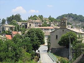
Vaumeilh is a commune in the Alpes-de-Haute-Provence department in the Provence-Alpes-Côte d'Azur region in southeastern France.

Contents

Map of 04200 Vaumeilh, France

Geography

It is a small Provençal village with narrow, winding streets which backs on to a hill. The Durance flows 1 km (0.62 mi) away below a plateau which grows mainly cereals and apples and also supports some livestock.

Origin of the name

The most common theory is that name comes from the Latin Vallis Mellis which is translated as valley of honey. Charles Rostaing suggested that the name sounds like a word for mountain and so this might be its origin. Ernest Nègre proposed that the name is composed of Latin 'vallem' and the Roman name 'Maelius'.

History

The village was mentioned, as 'Vaumel', for the first time in charters dated 1171. It was occupied by Protestants at the end of the French Wars of Religion. A 'patriotic society' was created in the spring of 1792, which was one of 21 in the department of Alpes-de-Haute-Provence to debate political matters.

Administration

List of mayors:

  • March 1989 - March 1995 Louis Touche
  • March 1995 - March 2001 Jean-Marie Collombon
  • March 2001 - March 2008 Georges Richaud
  • March 2008 - to date Élisabeth Collombon
  • Population

    Chart of the population of Vaumeilh since 1765

    The inhabitants are called Vaumeilhois.

    Sights

  • A priory, Notre-Dame de Chane, existed in 1210, and depended on the monastery in Aniane. It fell in ruins in 1469, was given to the Church of Gap, which rebuilt it with mainly agricultural objectives around a triple court between the end of the 17th century and the French Revolution. A dovecote which is the oldest in the department dating from the 15th or 16th centuries was built almost entirely out of large boulders.
  • The parish church was built in 1667. It has fine stained glass and marble statues
  • The chapel of Saint Marcellin, below the village, was built around 1770
  • There is a monument to the fourteen dead of the First World War
  • A tower remains from an ancient feudal manor that was destroyed during the French Revolution
  • The town square (Place de Trois Torrents) was enlarged adding a children's play area and a "kiosk" (bandstand). This was formally opened 10 July 2010.
  • The "sentier des Contes" (the Tales' Path) starting from Fombeton Bridge is part of the "Trail of Talking Rocks". A special booklet available from tourist offices when pressed to the right rock will trigger an electronic story about the location.
  • The airfield midway between Vaumeilh and Thèze is well known for the sport of gliding and attracts many visitors each year for flights and for its restaurant
  • References

    Vaumeilh Wikipedia