
NRHP Reference # 98001257 Nearest city Cave-In-Rock | Area 14 ha Added to NRHP 5 November 1998 | |
 | ||
MPS Caught in the Middle: The Civil War on the Lower Ohio River MPS | ||
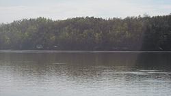
Battery Rock is a limestone bluff located at Mile 860 of the Ohio River in Hardin County, Illinois, across from Caseyville, Kentucky. The bluff is a prominent navigational landmark along the river.
Map of Battery Rock, Rock Township, IL 62919, USA
The site played a role in several conflicts during the Civil War. In 1862, the Union Army based its troops at Battery Rock during a standoff with Confederate troops at Caseyville; the standoff ended when the Union troops moved to Caseyville, found that the Confederates had left the town, and punished the rebellious residents. The bluff also played a role in Confederate general Stovepipe Johnson's attack on riverboats in 1864. During the attack, boats used the landing at Battery Rock as a safe harbor and a place to monitor the situation. In addition, two Union recruiters from Kentucky used the bluff as a recruiting station in 1864, and either a Union garrison or a local defense force placed two cannons at the site; graffiti left by an Indiana regiment has also been found at the site.
The bluff was used as a filming location for the film How the West Was Won in the 1960s.
Battery Rock was added to the National Register of Historic Places on November 5, 1998.