
Intercommunality Pays de Banon Area 39.81 km² | Canton Banon Population (2010) 1,070 Local time Thursday 3:12 AM | |
 | ||
Weather 2°C, Wind NW at 6 km/h, 84% Humidity | ||
Banon is a French commune in the department of Alpes-de-Haute-Provence in the Provence-Alpes-Côte d'Azur region of south-eastern France.
Contents
- Map of 04150 Banon France
- Geography
- Geology
- Relief
- Hydrography
- Environment
- Climate
- Natural and technological risks
- Transport network
- Toponymy
- Prehistory and Antiquity
- Middle Ages
- Modern Times
- French Revolution
- Contemporary Era
- Administration
- Inter communality
- Budget and Taxation
- Demography
- Overview
- Agriculture
- Industry
- Service activities
- Education
- Sports
- Health
- Communal services
- Worship
- Civil heritage
- Religious heritage
- Banon and the cinema
- Notable people linked to the commune
- References
Map of 04150 Banon, France
The inhabitants of the commune are known as Banonais or Banonaises.
Geography
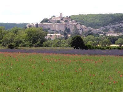
Banon is located next to the Plateau of Albion some 15 km north-west of Forcalquier, 50 km east of Carpentras, and 760 m above sea level. The village is on a hill overlooking the Coulon valley. Access to the commune is by the D950 road from Revest-du-Bion in the north-west which passes through the village and continues south-east to Limans. The D51 goes south-west from the village to Simiane-la-Rotonde. The D5 goes south-east to Revest-des-Brousses. The D12 goes north from the D950 and loops around to join the D950 again east of the commune. Apart from the village there are the hamlets of L'Adret, L'Adrech, and Le Serre. The commune is farmland on the lower areas to the west and forested on the heights in the east.
Geology
Limestone, dating from the Cretaceous period, is the predominant rock in the commune although in the Riaille valley it is Barremian limestone. The limestone is used for construction, especially for wall ties, framing, and lower walls, as well as for fountains. Depressions, oriented SSW-NNE and NNW-SSE are formed of marl and sandstone from the Upper Cretaceous period. Limestones and porous rocks allow water to infiltrate down to a substrate of Neocomian marl. These infiltrations scour the rocks causing the formation of sinkholes or Avens (Pitches) such as the Aven of Belette. The waters circulate at a speed of 77 metres/hour.
Relief
Hydrography
The Ravin du Calavon rises just east of the village and flows south, becoming the Calavon river (also known as the Coulon), which eventually joins the Durance south-east of Cabannes. The Riaille river flows south through the western side of the commune and the village before joining the Calavon south of the commune. The Largue flows from the north down the eastern side of the commune and continues south to join the Durance east of Manosque.
Environment
The commune has 2,271 hectares of woods and forests.
Climate
Banon is located in Alpes-de-Haute-Provence and enjoys an interior Mediterranean climate with summers hot and dry but the winters are cool and marked by frequent frosts. The annual average temperature is 12.8 °C with an average maximum of 22.4 °C and an average minimum of 0 °C. The highest maximum and minimum temperatures are 30 °C in July and 0 °C in December and January. Average sunshine hours are 2,755 hours per year with a peak of 343 hours in July. Another important characteristic of the Mediterranean climate is the rainfall which totals 426 millimetres over the year, unevenly distributed with a little more than 21 millimetres in July and more than 54 millimetres in October. The mistral blows sometimes although the town is sheltered by the Lure mountain. It may be more exposed to the Levant or the Sirocco which rarely occur.
The nearest weather station to Banon is in Saint-Christol in Vaucluse, a little farther away than Forcalquier.
Natural and technological risks
None of the 200 communes in the department are in a no seismic risk zone. Banon is in zone 1a (very low risk but not negligible) according to the deterministic classification of 1991 based on the historical earthquakes, and zone 3 (moderate risk) according to the EC8 probabilistic classification of 2011. Banon is also exposed to three other natural hazards:
Banon is not exposed to any risk of technological origin identified by the Prefecture.
There is no risk prevention plan for foreseeable natural risks (PPR) for the commune and there is no DICRIM.
Transport network
Several bus lines connect Banon to other communes in the region. The places served are: Apt, Forcalquier, Digne-les-Bains, Avignon, and Manosque. There is also a bus service on market days (Tuesdays) to neighbouring communes.
The nearest airport and railway station are at Avignon.
Toponymy
The area appears for the first time in texts from the 11th century (castrum Banonni). According to Charles Rostaing the name is formed from the oronymic root Ban meaning "horn" or "point". According to this author the name predates the Gauls. This explanation is also shared by Fénié and Claude Martel, for whom this explanation also applies to Grou de Bane. According to Ernest Nègre, Banon comes from a Germanic proper name Bano.
Banon in Vivaro-Alpine dialect and in Provençal dialect is said and written Banon in the classical norm and Banoun in the Mistralian norm.
Three main factors explain the toponymy of the commune: the relief between the Albion plateau and the Lure mountain, its location in the Occitan linguistic area, and the people of the area. The terrain is very present: the Pié d'Enroux is formed from a local evolution of the Latin podium meaning "height". The pey in Peymian has the same origin, the name of this hill meaning "the mountain of the middle". The name of the Puy de Salve is formed from the most current evolution in France of podium and there is also the Crête de Gamby (Gamby Ridge). The Coueste Chaude (to the west of the village) is on the slope of a mountain, Occitan derived from the French côte. Other names are formed from the words adret (sunny side of a mountain) and ubac (shady side): thus there are the Adret and the Ubac of Grou de Ban, the hamlet of Adrech at the foot of the Grou, and the Ubac farm at the foot of the Pié d'Enroux. The Combe de Vaux is a pleonastic doublet to designate a valley.
The work of hydraulic erosion on limestone has created avens (sinkholes) including at least one with a specific name: the Aven de Goutin. Amplified by deforestation, the same erosion moves large quantities of stones from the mountain slopes and deposits them on the plains, sometimes covering arable land: this is the origin of the name of Gravières south of the village.
The relatively high flat arable areas are called plains even though they are on a mountain: this name is used in Plaines (at the northern border of the commune) and in the hamlet of Plaines (in ruins) on the southern boundary (as well as these there is the toponym le Nord des Plaines). Le Plan is also a small plain.
Water is also present in the toponymy: there is the water source called Font des Petits and a marshy area called La Palud. A valley is named Aiguebelle meaning "beautiful water". The reference to water is rare in the toponymy of this dry region.
The term grange (barn) in this area refers to an isolated farm: this toponym is present in La Grange (at the northern border of the commune), also at La Grange (outside the village), and in Les Granges de Dauban. The hill overlooking the village is called Le Défens: this is an area, owned by the lord or the community, where herds were banned. Le Clos de Gardon is a cultivable area where the material from road ballasting was used to enclose the fields and meadows with a dry stone wall. Les Chastellas was a fortification at high altitude (which has been confirmed by excavations, see below) and La Tuilerie was a tile production workshop prior to the 18th century (before the term tuilière was used).
Prehistory and Antiquity
The commune had inhabitants in prehistoric times: the discoveries of Paleolithic remains are quite numerous.
The are two oppida at Mures and Chastellard. At Font-Crémat, a Gallo-Roman villa and a necropolis have been discovered. A treasure of 700 denarii from Nero to Geta was discovered in a vase in 1909 as well as many other unrelated discoveries. During the Pax Romana the iron manufacturing workshops became established in the commune territory. Throughout this period the territory of Banon was part of that of the Sogiontiques (Sogionti) whose territory spanned south of the Baronnies of the Durance. The Sogiontiques were federated to the Vocontii and, after the Gallic Wars, they were attached with them to the Roman province of Gallia Narbonensis (now Narbonne). In the 2nd century they were detached from Voconces and formed a distinct civitas with Segustero (Sisteron) as its capital.
Romanisation can be seen in places such as the villas of Fouent-Crema: there were several houses and workshops or a Gallo-Roman hamlet settled on the plains north-east of Banon in the 1st and 2nd centuries AD. At the time of the Roman Crisis of the Third Century the whole area was burned (about 240-275). The people did not desert the commune as the site was occupied again in the 4th century before abandonment at the end of that century at the same time as the Chastelard de Lardiers nearby. The area then became a necropolis and the location of the inhabitants for this period has not been determined either in the immediate vicinity or on the heights.
While the south-east of Gaul was Burgundian land, the king of the Ostrogoths, Theodoric the Great, conquered the region between the Durance and the Rhône as well as Isère in 510. The commune depended briefly on Italy until 526. In order to reconcile with the Burgundian king Godomar III, the Ostrogoth Regent Amalasuntha gave him the territory.
Middle Ages
While Chastelard was abandoned, there remained a visual (in the landscape) and symbolic (in attitudes) cue in that the border with the neighbouring community of Lardiers was fixed along the side of the oppidum in a process that seemed common.
The village was fortified in the 11th century (it was the castrum banonum in the charters of the time). During the Middle Ages the Church of Our Lady depended on the Abbey of Cruis who received the income attached to this church as well as those of the Chapel of Saint-Hilaire (disappeared) and returned it to Sénanque Abbey.
The fief of Simiane (from the 12th century to the 1789 revolution) was devastated by Raimond de Turenne in 1391. The Banon community was then within the viguerie of Forcalquier.
Modern Times
A fair was held at Banon until the 18th century.
There was a windmill in Banon (probably after the 17th century). Its ruins are located near the Clos de Gardon.
French Revolution
During the French Revolution the commune had a patriotic society which was founded after the end of 1792. The medieval castle was razed during the Revolution.
Contemporary Era
The French coup d'état of 1851 committed by Louis-Napoléon Bonaparte against the French Second Republic provoked an armed uprising in the lower Alps in defence of the Constitution. After the failure of the insurrection severe repression continued against those who defended the Republic: 17 inhabitants of Banon were brought before the Joint Committee and the majority were sentenced to exile in Algeria.
As with many communes in the department, Banon adopted schools well before the Jules Ferry laws. The scattered settlements led to doubling of the facilities with, in 1863, two schools installed in the main town and the village of Largue at the east and west extremities of the commune. These schools provided primary education for boys and girls: the Falloux Laws (1851) required the opening of a girls' school in communes with more than 800 inhabitants. The commune benefited from grants from the second Duruy Law (1877) to rebuild the Largue village school and to build a new one at Granges de Dauban.
The village people started moving in the 19th century: people began to abandon the tight housing on the heights to build their houses near the crossroads of the roads to Sisteron, Apt, Manosque and Forcalquier in about 1840-1880. This new community was called La Bourgade. The old village was not abandoned immediately as the church was enlarged and a hospital was built on the heights. In 1887, however, a college was built in the new village on the Market Square (Place du Marché). In 1905 a water jet fountain sourced from the Brieux and fed by an underground aqueduct 3 km long was built in the new village. Thereafter all new buildings, private or public, were built in the lower village (a church in 1911, a hospital in 1930) and, in 1950, the Orchards began to be converted to housing zones.
In the 20th century the cultivation of lavender commenced and a distillery was founded.
At the end of the Second World War the police station moved to Forcalquier.
Administration
List of Successive Mayors
(Not all data is known)
Inter-communality
Banon is part of the Community of communes of Pays de Banon which is a group of 12 communes.
Budget and Taxation
The Regional part of the Housing tax is not applicable.
The Professional Tax was replaced in 2010 by the corporate property contribution (CFE)on the rental value of property and the contribution of value added companies (CAVE) which both form the territorial economic contribution (CET), a local tax introduced by the Finance Act 2010.
Demography
In 1471 the commune had 46 fires and in 1765 had a population of 848.
In 2010 the commune had 1,070 inhabitants. The evolution of the number of inhabitants is known from the population censuses conducted in the commune since 1793. From the 21st century, a census of communes with fewer than 10,000 inhabitants is held every five years, unlike larger communes that have a sample survey every year.
Sources : Ldh/EHESS/Cassini until 1962, INSEE database from 1968 (population without double counting and municipal population from 2006)
The demographic history of Banon, after the bloodletting of the 14th and 15th centuries and a long period of growth until the beginning of the 19th century, was marked by a period of "stagnation" where the population was relatively stable at a high level. This period lasted from 1831 to 1851. The rural exodus then caused a long-term population decline. In 1954, after more than a century of decline, the town had lost over half of its population relative to its historical high in 1841. The decline, however, reversed from the 1960s with a growth of 50% in half a century.
Overview
In 2009 the active population was 435 people, including 68 unemployed (50 at the end of 2011). These workers are mostly employees (75%) and mainly work in the commune (62%). Agriculture is still very present with 32 active establishments in 2010. Industry and construction employ 19% of the active population and services and administration employ a little over 80%.
On 1 January 2011 the businesses active in the commune were mainly in the tertiary sector (231 of the 287 businesses).
Agriculture
In late 2010 the primary sector (agriculture, forestry, fishing) had 32 establishments within the meaning of INSEE and 16 farm holdings according to the Agreste survey by the Ministry of Agriculture. This number is down significantly in the 2000s, from 27 to 16 in 10 years. From 1988 to 2000 the utilised agricultural area (UAA) has fallen sharply from 2,043 hectares to 1,207 hectares of which 1,006 hectares are crops. This area has doubled in the 2000s. In contrast, establishments practicing polyculture have disappeared. Sheep and permanent crops (various tree crops, fruit, truffles, and lavender) representing the remaining enterprises.
Vineyards, a component of the Mediterranean triad, was formerly present in Banon. In the 19th century there were several dozen hectares of vineyards producing wine for home consumption and sale in local markets with a small amount sold on the regional market. Currently the surface area of vineyards is insignificant.
Industry
In late 2010 there were 31 establishments in the secondary sector (industry and construction) employing 55 employees.
Banon has become famous for its small goat cheeses wrapped in dry chestnut leaves and tied with raffia strings.
The Banon cheese factory employs 38 people. Over 600,000 individual cheeses are produced each year. Banon cheese is the only appellation d'origine contrôlée (AOC) in the Provence-Alpes-Côte d'Azur region.
The phosphate mines are closed but the quarry is exploited by Carrières de Haute-Provence (Haute-Provence Quarries) who still process the local limestone into aggregate.
Service activities
In late 2010 there were 75 establishments in the tertiary sector (trades and services) with 75 employees plus 35 administrative, social, health, and education sector institutions employing 156 people.
The village is notable for one of the largest independent bookstores in France, Le Bleuet, which offers more than 100,000 titles on their shelves.
According to the Departmental Observatory of tourism, the tourism function is important for the town with between 1 and 5 tourists per inhabitant visiting the commune each year. Most of the accommodation capacity is non-market (e.g. 2nd homes). The proximity of the Luberon Natural Regional Park energizes this sector of activity in the commune. Although not having any hotels, the commune still has several accommodation facilities for tourists:
There is also a significant capacity of 148 Second homes
A wide variety of shops is present in the commune:
Education
The commune has two educational facilities:
Sports
Many sports clubs are present in the commune for various sports including boxing, badminton, handball, judo, paragliding, hiking, and horse riding.
Health
There are many health practitioners in Banon: 3 physiotherapists, 4 doctors, 2 osteopaths, and a pharmacy.
Banon has a rural hospital with 68 beds which was built between 1984 and 1985. This hospital has an after-care service and 20 undifferentiated rehabilitation beds, 48 nursing home beds and 25 Nursing Service At Home (SSIAD) places. The building stands on the site of a former hospital built by donors belonging to old local families. It is served by 60 caregivers and administrative staff and is the largest employer in the commune.
Communal services
Several public services are available:
Worship
The commune is part of the Montagne de Lure parish sector and Catholic worship is celebrated alternately in each of the churches in the sector.
Civil heritage
Religious heritage
The scattered settlements explains the presence of numerous chapels and two parishes in the 19th century. At least four other chapels have disappeared. Banon has two parish churches and three chapels remaining:
Banon and the cinema
Banon is the village where the story takes place of The Man Who Planted Trees by Jean Giono. The animated film adaptation by Frédéric Back (1987) won the Oscar for Best Short Film in 1988.