
Country France Canton Forcalquier Population 4,650 (2004) | Arrondissement Forcalquier Area 42.76 km² Local time Tuesday 1:09 PM | |
 | ||
Intercommunality Pays de Forcalquier et Montagne de Lure Weather 17°C, Wind S at 10 km/h, 43% Humidity | ||
Forcalquier ([fɔʁ.kal.kje]; Occitan: Forcauquier [fuɾkɔwˈkje]) is a commune in the Alpes-de-Haute-Provence department in southeastern France.
Contents
- Map of 04300 Forcalquier France
- History
- Population
- Sights
- Personalities
- International relations
- References
Map of 04300 Forcalquier, France
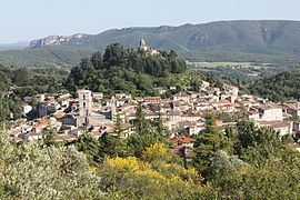
Forcalquier is located between the Lure and Luberon mountain ranges, about 30 km (19 mi) south of Sisteron and 10 km (6.2 mi) west of the Durance river. In the Middle Ages it was the capital of Haute-Provence.
History
Furnus Calcarius was the Latin name, from the lime kilns used in Roman times. (A Roman bridge still stands in the valley to the south of the town.) Its Provençal name is Fourcauquié. At the end of the 11th century, a family of the Counts of Provence created the comté de Forcalquier that remained an independent state through the 12th century.
During this time, the town of Forcalquier was the capital of Haute Provence along the Durance, which included the towns of Manosque, Sisteron, Gap and Embrun. Forcalquier minted its own currency, and its church was elevated to the status of a "concathedral".
The Counts of Forcalquier grew to a power that could defy the Counts of Provence. Rivalry ended in 1195 when Gersende de Sabran, comtesse de Forcalquier, married Alfonso II, the Count of Provence. Their son, Ramon Bérenger IV inherited the two counties.
Population
The inhabitants are called Forcalquiérens.
Sights
Forcalquier is built around the slopes of a steep conical hill, crowned by an octagonal chapel, Notre Dame de Provence, where the medieval citadel once stood. The citadel was destroyed in 1601; the chapel with its panoramic view was built in 1875. It has a carillon that can be heard every Sunday morning during the summer.
The oldest part of the town is the area around the Place Saint-Michel with its Renaissance fountain (1511) and its narrow side-streets. There many doorways dating to the 12th to 16th centuries can be found.
The present commercial and social center of town, the Place du Bourget, is located below the Place St. Michel. The 12th century "concathedral" Notre Dame de l'Assomption with its bell towers stands across from the Place du Bourguet.
The Cordeliers Convent was built in the 13th century by Franciscans named "cordeliers" because of their rope belts. This convent was occupied by monks continuously until the Revolution. It now houses the Université Européenne des Senteurs & Saveurs. The Port de Cordeliers is all that remains of the town's fortified walls.
Monday morning is market day in Forcalquier. The market fills the Place du Bourguet and the adjoining streets.
Noteworthy is the Musée Municipal with its prehistoric and Gallo-Roman artifacts, glass works, and faïence pottery from Mane, Apt and Moustiers-Sainte-Marie.
Personalities
International relations
Forcalquier is officially twinned with: