
Country State | ||
 | ||
Languages spoken Bengali, English | ||
Map of Bally, Howrah
Bally is a town in Howrah District, West Bengal, India.This area is covered by Howrah Municipal Corporation. It is a town of historical importance. Located at the north-eastern tip of the Howrah district, on the banks of the River Hooghly, it is just across the river from the Dakshineswar Kali Temple and near the Belur Math.
Contents
Geography

Bally is located at 22.65°N 88.34°E / 22.65; 88.34. It has an average elevation of 15 metres (49 feet). There is a man-made canal named the 'Bally Khal' that marks the boundary between Bally and the adjoining town of Uttarpara in Hooghly District. Once Uttarpara was the northern part of Bally; Uttarpara means "Northern Ward." The Hooghly river separates it from Dakshineswar of North 24 Parganas district.
Temples
Kalyaneshwar Mandir is a Shiva temple situated in Bally, Howrah, in the Indian state of West Bengal. It is more than 500 years old and is visited by thousands of monks and devotees every year. It is surrounded by Kali, Ganesh, Vishnu and Bajrangbali Temples. It is situated at the north-eastern tip of the Howrah district, on the banks of the River Hooghly, across the river from the Dakshineswar Kali Temple and near the Belur Math. The temple was set up by villagers more than 500 years ago, sponsored by the Jamindar (local land lord) of that time. Legends say that Ramakrishna Dev visited the temple frequently along with his followers from Ramakrishna Mission, including Swami Vivekananda and Swami Brahmananda. This ritual is still followed by the monks of Ramakrishna Mission.
Festivals
Festivals in this temple are Maha Shivaratri and Charaksankranti. Other important festivals include Ramnavami and Rash mela. Apart from all these the Saraswati Puja of Bally is so famous which pulls crowd from neighbouring areas.
Transportation
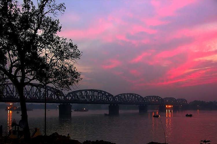
Bally is well connected by road, rail and water. Three major railway lines connect Bally, the Howrah–Bardhaman main line (or Tarakeswar main line), the Howrah-Barddhaman Chord Line and the Sealdah-Dankuni Line. There are five railway stations (Bally Ghat, Bally Halt, Bally, Rajchandrapur, Bally Main and Belanagar) (also known as the Calcutta Chord Rail). The Grand Trunk Road/SH 6 passes through Bally. The town is connected with the northern bank of the Ganges by the Vivekananda Setu (formerly known as Bally Bridge) and the Second Vivekananda Bridge (also known as Nivedita Setu). Central Kolkata is 10 km from Bally. Bally has a ferry pier - Bally Ghat. Bally is a suburb of Kolkata.
Demographics
As of 2001 India census, Bally had a population of 261,575. Males constitute 57% of the population and females 43%. Bally has an average literacy rate of 77%. male literacy is 78%, and female literacy is 74%. 8% of the population above 6 years of age.