
PIN 325206 Local time Wednesday 3:06 AM | Time zone IST (UTC+5:30) Telephone code 07457 Area code 07457 | |
 | ||
Weather 21°C, Wind W at 5 km/h, 40% Humidity | ||
Baldara is a town in western India located in state of Rajasthan. It is the administrative headquarters of the Gram panchayat.
Contents
- Map of Baldara Rajasthan
- Geography
- Baldara is known for
- Transportation
- Divisions
- Economy
- Climate
- Other
- References
Map of Baldara, Rajasthan
Geography
Baldara is located 310 kilometers (193 mi) southeast of the state capital, Jaipur, and 32 kilometers (20 mi) northwest of Baran, at 25°14'39.18"N 76°17'12.44"E. The town is bounded on the east, north, south by Baran district & in west by Kota district.
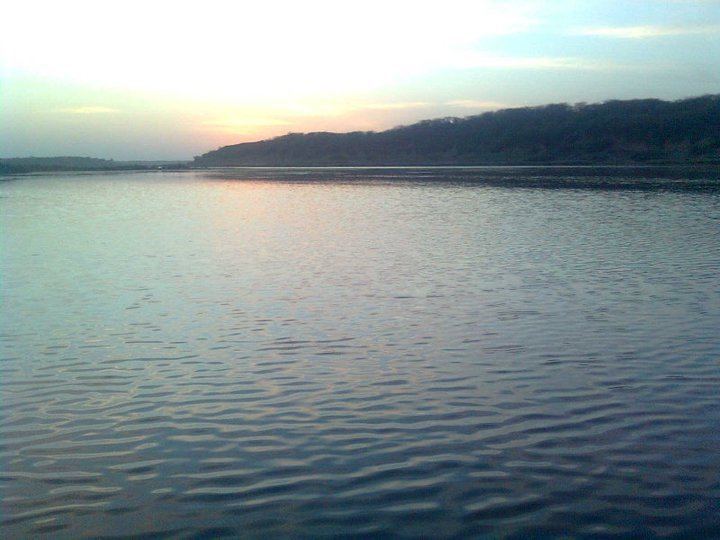
Baldara is known for
→ Baldara is known for the Kali Sindh, one of the most attractive rivers in the state.
→ Majare sharif of Hajrat dadaji moulvi sb is located in kabristan baldara.
→ Dargāh Sharīf of Hazrat Sufi Sayyed Mehmood Ali Shah Kanpuri summa Baldari is situated between Jagapura & Basheerpura.
→ The late Haji Nihal Ahmed was another dynamic, social, political personality of Baldara. He was the Sarpanch of Baldara for about 35 years. He was the social reformer of the society, and was known as "Sarpanch sab".
→ Haji Abdul Razzaq was a dynamic, memorable, charitable personality of Baldara. He changed the environment of this village in education and agriculture field, and helped needy people. Villagers called him "Masiha of poors". Everybody called him by his respectful nickname "Bhayyaji"
→ Molana Namdar Ahmed was a respected personalty of Baldara. He is known as Molana and Qazi e Baldara, as well as first khalifa of" Sayyed Mehmood Ali Shah Sb. He is known for simplicity. He was strictly panchghana Namazi and a well-known social reformer.
→ Late Er. Rukhsar Ahamed Mahmoodi was another dynamic personality of Baldara. He was a well-educated, integrating, humanitarian. The Rukhsar Ahmed memorial and charitable fund was formed in remembrance of him. This trust works for education, poor, needy, orphans and many more welfare programs in the area.
Transportation
Transportation in Baldara is provided mostly by unmetered taxis and bus services on main roads from Kota Airport to Baran. The town is located about 12 kilometers from National Highway 27(NH 27), halfway between Kota and Baran. Antah station is the nearest railway station, located 12 kilometers from the town. It is a direct link of Kota-Beena railway line.
Divisions
There are 5 sub-divisions and village: Baldara, Roop-pura (Nayagaon), Sindhpuri, Sindhpuri-Fectory, Tikhod, Ganeshpura. Baldara is the centre for FPS shops, banking, education, and a market for basic requirements. Baldara is Panchayat headquarters for all these villages.
Economy
There are many sandstone, sand, and gravel mines in the Baldara. The town is the biggest producer of sandstone & fish in the district. Garlic, mustard, and wheat are the main crops grown here.
Climate
The town has a tropical climate due to its proximity to the Tropic of Cancer with extremely hot summers.
The summer season in Baldara lasts from April to late October or November. The average temperature in the daytime is around 43 °C during this period. Winters are comparatively mild, with average temperatures being in the range of 26.7 °C (max) to 7 °C (min).
The average annual rainfall in Baldara is 885.6 mm.[2] Most rainfall comes from the southwest monsoon beginning around the last week of June and lasting until mid-September. Pre-monsoon showers begin towards the middle of June with post-monsoon rains occasionally occurring in October. The winter is largely dry, although some rainfall does occur as a result of the Western Disturbance passing over the region.
Other
Railway stations near Baldara:
Schools Near Baldara
Colleges Near Baldara