
Area 15.24 km² Population 114 (1999) | Time zone CET (UTC+1) Local time Tuesday 5:06 PM | |
 | ||
Intercommunality Métropole Nice Côte d'Azur Weather 10°C, Wind W at 13 km/h, 71% Humidity | ||
Bairols (Occitan: Bairòls) is a French commune in the Alpes-Maritimes department in the Provence-Alpes-Côte d'Azur region of south-eastern France.
Contents
Map of 06420 Bairols, France
The inhabitants of the commune are known as Bairolois or Bairoloises.
The commune has been awarded two flowers by the National Council of Towns and Villages in Bloom in the Competition of cities and villages in Bloom.
Geography
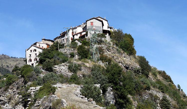
Bairols is located at an altitude of 830 metres on a rocky ridge some 20 km north of Gilette and 5 km north of Villars-sur-Var. Access to the commune is by the M26 road from Tournefort in the south which passes through the south-eastern corner of the commune and connects with the tortuous M56 road which continues to the village. The commune is a rugged alpine commune.
The Tinée river forms the eastern border of the commune as it flows south to join the Var. Many tributaries rise in the commune and flow east to join the Tinée including the Vallon du Serre, the Ruisseau de Fava, the Vallon du Bairols, and the Ravin de Saint Martin.
History
The name Bairolum is cited around 1040. The village was then given to Lérins Abbey then became a fief of the Grimaldi.
The village was linked to the outside world by a motorable road in 1939. There were still 257 inhabitants in 1858.
Administration
List of Successive Mayors
(Not all data is known)
Demography
In 2010 the commune had 107 inhabitants. The evolution of the number of inhabitants is known from the population censuses conducted in the commune since 1793. From the 21st century, a census of communes with fewer than 10,000 inhabitants is held every five years, unlike larger communes that have a sample survey every year.
Sources : Ldh/EHESS/Cassini until 1962, INSEE database from 1968 (population without double counting and municipal population from 2006)