Postal code 12230 | ||
 | ||
Time zone Sri Lanka Standard Time Zone (UTC+5:30) | ||
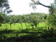
Baduraliya is a town in the Kalutara District in Sri Lanka. It is approximately 82 km from Colombo and 58 km from Rathnapura. Baduraliya was named after a rally against taxes. "Badu" in Sinhala means taxes and “raliya” means a rally. Baduraliya is surrounded by tea plantations and rubber estates, and it is at an altitude of 27 meters above sea level.
Contents
Map of Baduraliya, Sri Lanka
Baduraliya is the capital of a Division, with its secretariat called Palinda Nuwara. The division is known as Palinda Nuwara as it was the capital of King Veediya Bandara, who rebelled against the Portuguese in the 16th century.
Economy
The main economic activities in this area are the cultivation of tea and rubber. The town's agricultural industry is well developed. Few rubber and tea factories can be seen in the region. Tea grown in this region is called low-country tea. The area is known for rice, coconut, vegetable and fruit cultivations as well.
The town center includes commerce, retail enterprises, and many government offices. Buduraliya host to a government hospital, a police station, and few bank branches. The town is usually busy on Sundays because hundreds of people in nearby villages gather for Sunday fair.
The Kukule Ganga Hydroelectric Power Plant, which has the rated output of 70 MW, is located in this area. It is about 10 km away from Baduraliya town center and at Lathpandura - Molkawa (B584) road. In 2006, the power plant supplied about 4.0%of the total amount of electricity supplied in Sri Lanka at peak hours, and about 3.4% of the amount of electricity supplied per annum. The resort facility with a restaurant and a pool, which was originally built as a camp for European and American contractors of Kukule Ganga Hydroelectric Power Plant, has the capacity to accommodate about 200 guests with 64 guest rooms. It attracts many domestic tourists and the rooms are nearly full during weekends and school vacations through the year. About 60 local residents are employed by the resort facility.
Transport
Baduraliya is located in B 421 Highway which connects Agalawatte and Thiriwanakatiya. Baduraliya is easily accessible via the Southern Expressway (Sri Lanka). The town is about 26 km eastward to the Dodangoda Interchange. It is also accessible via Horana, Palawattha or Kalawana.
Buses are one form of public transportation modes in Baduraliya. A considerable number of school students commute for Matugama, where the so-called popular schools can be found. Some workers commute for Colombo spending more than two hours in one-way trip using buses. These are the evidences for the existence of reliable public transportation system in the area. The buses run every 20 minutes for Matugama during day times. Buses for Colombo, Panadura, Kalawana, Kalugala, Hadigalla and Kelinkanda are also available.
Other forms of transportation modes such as vans and other taxis can be found from a yard in the center of town. Three wheelers can be found almost anywhere in the town.
Climate
Baduraliya has a tropical rainforest climate under the Köppen climate classification. The town receives rainfall mainly from south-western monsoons from May to September. During the remaining months of the year, there is also considerable precipitaion due to convective rains. Average temperature range from 22 to 33 °C year round, and there are high humidity levels. The town is in the south-western part of Sri Lanka, the so-called wet zone.
