
Postal codes 07351–07356 Area 48.94 km² Population 6,570 (31 Dec 2008) | Time zone CET/CEST (UTC+1/+2) Dialling codes 036651 Local time Tuesday 12:44 AM Dialling code 036651 | |
 | ||
Weather 8°C, Wind S at 26 km/h, 65% Humidity Points of interest Regionalmuseum, Burgruine Lobenstein, Berg‑Museum Markt Höhler, Alter Turm | ||
Von saalburg nach bad lobenstein th ringen
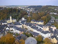
Bad Lobenstein is a spa town in the Saale-Orla-Kreis district, in Thuringia, Germany with a population of about 6,000 inhabitants. Until 2005, the town was named Lobenstein.
Contents
- Von saalburg nach bad lobenstein th ringen
- Map of Bad Lobenstein Germany
- 13 01 2017 sturmtief unwetter egon bad lobenstein friesau
- History
- Coat of arms
- Etymology
- Geography
- Districts
- Neighbouring communities
- Incorporating communities
- Population growth
- Sights of Bad Lobenstein
- Sons and daughters of the town
- Other personalities
- References
Map of Bad Lobenstein, Germany
The town, grouped round a rock, upon which stand the ruins of an old castle, is exceedingly picturesque. It contains a spacious parish church, a palace (until 1824 the residence of the princes of Reuss-Lobenstein-Ebersdorf), and a hydropathic establishment. The manufactures include dyeing, brewing and cigar-making.
13 01 2017 sturmtief unwetter egon bad lobenstein friesau
History
Within the German Empire (1871-1918), Lobenstein was part of the Principality of Reuss-Gera.
Coat of arms
Blazon: "In red floating the silver-black divided trunk of a bracke"
The trunk of the bracke (a certain type of dog group) is the crest of Principality of Reuss-Greiz (German: Fürstentum Reuß-Greiz). The image was already used in 15th century as coat of arms for the town.
Etymology
Lobenstein could come from "Lobe den Stein" which means "Praise the stone".
A legend describes how the inhabitants believe the town's name might have been established. It is believed that emperor Ludwig the Bavarian, who lived from 1328 to 1347 announced "Praise the stone" as he had lost and found his favourite dog in this region during hunting for deer. He was looking for the dog for quite a while until finally one of his knights found the tired and slightly injured dog lying on a stone. The knight caried the dog to his master, who was so grateful, he gave this piece of land as fief to the knight. In memory of this event, the place received the name Lobenstein and caried from now on the head of a bracke in its coat of arms.
Geography
The town is located in the Thuringian Slate Mountains between Thuringian Forest and Franconian Forest, western to the Saale river dams Hohenwarte and Bleiloch next to Gräfenwarth.
Districts
Neighbouring communities
Incorporating communities
On 4 August 1993 previously independent municipalities Helmsgrün and Lichtenbrunn got incorporated into the community of Bad Lobenstein. On 1 January 1997 also Unterlemnitz and in 1999 Oberlemnitz got in incorporated.
Population growth
Demographic development (from 1994 on each number was counted on 31st December):
Data source from 1994: Thuringian State office for Statistics