
Time zone CET/CEST (UTC+1/+2) Population 18,802 (31 Dec 2008) | Postal codes 74177 Local time Tuesday 12:18 AM | |
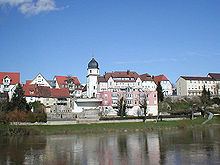 | ||
Weather 8°C, Wind SW at 21 km/h, 87% Humidity Points of interest Schloss Lehen, Greckenschloss, Salzbergwerk Bad Friedrichshall, Altes Rathaus Kochendorf | ||
Tour of the salt mine bad friedrichshall germany
Bad Friedrichshall is a town in the district of Heilbronn in Baden-Württemberg in southern Germany. It is situated at the confluence of the Jagst and the Kocher into the Neckar, 10 kilometres (6 mi) north of Heilbronn. Bad Friedrichshall arose by the connection of Kochendorf and Jagstfeld in 1933, and is famous for its salt-mine.
Contents
- Tour of the salt mine bad friedrichshall germany
- Map of Bad Friedrichshall Germany
- Bildimpressionen bahnhof bad friedrichshall jagstfeld am fr hen morgen 2015
- Geography
- Neighbouring municipalities
- Town structure
- History
- Kochendorf
- Bad Friedrichshall
- The mayor
- District council
- Arms and flag
- International relations
- Notable buildings
- Regular events
- Transport
- Local businesses
- Media
- Public institutions
- Education
- Personalities
- References
Map of Bad Friedrichshall, Germany
Bildimpressionen bahnhof bad friedrichshall jagstfeld am fr hen morgen 2015
Geography
Bad Friedrichshall is situated at the confluence of the Jagst and the Kocher into the Neckar.
Neighbouring municipalities
Neighbouring towns and villages of Bad Friedrichshall are (clockwise from the south): Neckarsulm, Untereisesheim, Bad Wimpfen, Offenau, Gundelsheim, Neudenau, Neuenstadt am Kocher and Oedheim, which all belong to the district of Heilbronn. Bad Friedrichshall has combined with Oedheim and Offenau to form a joint association of administrations.
Town structure
Bad Friedrichshall is subdivided into the parts of Kochendorf, Jagstfeld, Hagenbach, Duttenberg, Untergriesheim und Plattenwald. Heuchlingen is a hamlet and belongs to Duttenberg. The hamlets Waldau and Hasenmühle previously belonging to Hagenbach are parts of Kochendorf now.
History
Bad Friedrichshall arose in 1933 by the connection of Kochendorf and Jagstfeld. The name Friedrichshall is derived from a salt-works in Jagstfeld named by Frederick I in 1818. The term Bad is from a brine in Jagstfeld.
Kochendorf
Situated at the confluence of the Kocher and the Neckar on a hill there was presumably a consolidated estate, around which people settled and let arise the village of Kochendorf, that was first mentioned in 817. The St. Sebastian church probably already existed before 1100. Around 1200 Kochendorf got bricked in. In the 13th century a gentry of Kochendorf appeared. It dealt with ministerialis of the Staufers in Wimpfen. In the 15th and 16th century the gentry let build three castles. In 1672 the Freiherrs of Saint-André bought a third of the village and let build a new castle on one of the former castle sites.
The Ritterkanton Odenwald, who was able to buy the whole village in 1762 from the former heirs, made Kochendorf as their chancellery and carried on a knightly hotel which doesn't exist anymore. In 1806 Kochendorf came to Württemberg as a free municipality. In 1899, a salt-works of the Salzwerke Heilbronn AG was opened.
Besides there was a big former Jewish parish. Jews are proved there living since the 16th century; a synagogue was built around 1740, which got replaced by a new construction in 1806. Until 1854 the parish grew onto 154 people and represented nearly 9% of the village population. However, the parish decreased by migration and emigration in the following time enormously. In 1880, there was just an amount of 71 Jewish inhabitants and in 1925 there were only 7 Jews. Then the synagogue was sold to the Protestant parish, the Jewish parish broke up even before 1933. Five of the last seven Jews in Kochendorf were killed by persecution in 1940-43.
Bad Friedrichshall
Kochendorf got connected with the neighbouring Jagstfeld into Bad Friedrichshall in 1933. Two years later, Hagenbach was incorporated. In 1944, a subcamp of the Natzweiler-Struthof KZ was established by the SS in Kochendorf.
On June 17, 1951, Bad Friedrichshall was raised onto a town. On March 15, 1972, Duttenberg was incorporated. Untergriesheim followed on January 1, 1975. The district Plattenwald was rebuilt from 1992 until 1998 within the framework of a flat building program of the state Baden-Württemberg.
The mayor
District council
Following the municipal election of 25 May 2014, the district council of Bad Friedrichshall has 28 seats. The election result is as follows:
The mayor is also a member of the district council and its chairman.
In Untergriesheim, Duttenberg, and Plattenwald, there is also a village council of each of the villages. Following its suggestion, the district council elects an honorary chairman for every village. These bodies hear matters of concern to each village.
Arms and flag
Blazon: Within the split sign on top of three blue waves a blue globus cruciger with a silver hoop and a black cross, behind in blue a straightened up horse.
The town’s colours are blue and white; town logo:
The Friedrichshalls coat of arms was originally arranged on December 1, 1936, between the town and Württemberg's archive direction. It connects the seal and weapon figures of Kochendorf and Jagstfeld. The three blue waves symbolize the rivers Neckar, Jagst and Kocher. The seal of Jagstfeld derived since 1797 shows a Fleckenzeichen.
The flag colours blue and white were laid down in 1951. Arms and flag were given by the ministry of the interior of Baden-Württemberg on March 4, 1963.
International relations
There are town twinnings with
Notable buildings
Regular events
Transport
Bad Friedrichshall-Jagstfeld is an important railway junction, which represented a border station of Baden and Württemberg between 1869 and 1920. Today this is visible by the large railway yard, since the station building was situated in the middle.
At Bad Friedrichshall-Jagstfeld station the Elsenz Valley Railway and the Neckar Valley Railway (from Heidelberg via Sinsheim and Mosbach respectively) connect with the Franconia Railway from Stuttgart to Würzburg. There was also the Lower Kocher Valley Railway to Ohrnberg until 1993.
In Kochendorf and Untergriesheim there are further stations of the Franconia Railway, only served by RegionalBahn trains. Duttenberg-Obergriesheim station on the same line was closed in 1971.
Public transport is managed by the PTE HNV.
The Bundesstraße B 27 (Blankenburg (Harz)–Schaffhausen) passes through the town and connects to the Bundesautobahn 6.
Local businesses
The Südwestdeutsche Salzwerke AG (SWS) carried on the salt-mine Kochendorf from 1899 until 1994, which created a hollow space below Bad Friedrichshall and Neckarsulm of about 12 million cubic metres (420×10^6 cu ft). In 1901 the shaft was christened to William II. Since the mine had just one shaft at its disposal, a 3.7-kilometre (2.3 mi) long subterranean connection to the plant of Heilbronn maintained by the same factory was built in 1984. It was built as a further possibility to evacuate in case of emergency. Between 1994 and 2015 the mine will be filled with rubble and hazardous waste. However, a visitor's mine is still open; it features a subterranean dome hall of the 1920s.
The factory Richard Hengstenberg GmbH & Co. KG produces conserves in Kochendorf. The factory Hänel Büro- und Lagersysteme founded in 1953 takes action in the production of storekeeping systems consisting subsidiaries in Wiesentheid, the Swiss Altstätten SG and further ones abroad. The Zahnradfabrik Hänel belongs to the same group producing cogwheels.
Media
About happenings in Bad Friedrichshall the Heilbronner Stimme (edition north-middle) and the official paper Friedrichshaller Rundblick are reporting.
Public institutions
In Plattenwald there's the Klinikum am Plattenwald (district hospital) consisting 422 beds.
Education
In Bad Friedrichshall there are six primary schools in Duttenberg, Hagenbach, Höchstberg-Untergriesheim, Jagstfeld, Kochendorf and Plattenwald. Besides there's a Hauptschule and Werkrealschule, the Otto-Klenert-Realschule and the Friedrich-von-Alberti-Gymnasium. Bad Friedrichshall has also a city library at its disposal.