Harman Patil (Editor)

Wiesentheid

Updated on
Edit
Like
Comment
Share on FacebookTweet on TwitterShare on LinkedInShare on Reddit
Country
  
Germany

Admin. region
  
Unterfranken

Elevation
  
249 m (817 ft)

Area
  
33.33 km²

Local time
  
Sunday 10:36 PM

State
  
Bavaria

District
  
Kitzingen

Time zone
  
CET/CEST (UTC+1/+2)

Population
  
4,810 (31 Dec 2008)

Postal code
  
97353

Wiesentheid httpsuploadwikimediaorgwikipediacommonsthu

Weather
  
12°C, Wind N at 8 km/h, 79% Humidity

Wiesentheid is a municipality in the district of Kitzingen in Bavaria in Germany.

Contents

Map of 97353 Wiesentheid, Germany

History

It was first mentioned in 918 as "Wisenheida". Mediatization in 1806 brought the former county of Schönborn into the Grand Duchy of Würzburg, along with which it became part of the Kingdom of Bavaria in 1814. The Bavarian Municipal Edict of 17 May 1818 (Gemeindeedikt (de)) formed today's Wiesentheid.
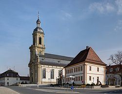
Main sights

  • Count's Castle Wiesentheid
  • Kanzleistrasse – street with historic administrative buildings
  • Schlossparkanlage – castle garden (English)
  • catholic church St.Mauritius built by Balthasar Neumann
  • historic vicarage
  • historic town hall
  • crucifixion memorial built by Jacob van der Auvera
  • historic Mariensäule (memorial of Mother Mary)
  • Sister city

  • Rouillac, Charente, France
  • Personalities

  • Johann Georg Fuchs von Dornheim, (1586-1633), prince-bishop of Bamberg, and fighters for the counter-reformation as well as ruthless sorcerers ("Hexenbrenner").
  • Carl Stumpf (1848-1936), philosopher, psychologist and musicologist
  • References

    Wiesentheid Wikipedia