
Intercommunality Vallées d'Ax Area 9.54 km² | Region Occitanie Canton Cabannes Population (2010) 24 Local time Friday 6:07 PM | |
 | ||
Weather 12°C, Wind NW at 34 km/h, 60% Humidity | ||
Axiat is a French commune in the Ariège department in the Occitanie region of southwestern France.
Contents
- Map of 09250 Axiat France
- Geography
- Administration
- Demography
- Religious heritage
- Environmental heritage
- References
Map of 09250 Axiat, France
The inhabitants of the commune are known as Axiatois or Axiatoises.
Geography
Axiat is located some 27 km south-east of Foix and some 12 km north-west of Ax-les-Thermes. Access to the commune is by the D20 road from Appy in the west which passes through the south of the commune and the village before continuing south to Lordat. The commune is alpine in nature with snow-capped mountains in the north, extensive forests, and rugged terrain. There is some farming activity in the south near the village.
The Ruisseau d'Axiat forms the southern border of the commune as it flows west to join the Ariege at Urs. The Ruisseau de la Cassagne forms the south-western border of the commune as it flows south to join the Ruisseau d'Axiat. The Ruisseau de Girabel forms the north-western border of the commune as it flows south to join the Ruisseau de la Cassagne. The Ruisseau de Sauquet rises in the north of the commune and flows south through the centre near the village and joins the Ruisseau d'Axiat on the southern border. The Ruisseau de Fontronne forms the eastern border of the commune as it flows south to join the Ruisseau d'Axiat on the southern border.
There is also a hamlet called Axiat in the commune of Miglos.
Administration
List of Successive Mayors
(Not all data is known)
Demography
In 2010 the commune had 24 inhabitants. The evolution of the number of inhabitants is known from the population censuses conducted in the commune since 1793. From the 21st century, a census of communes with fewer than 10,000 inhabitants is held every five years, unlike larger communes that have a sample survey every year.
Sources : Ldh/EHESS/Cassini until 1962, INSEE database from 1968 (population without double counting and municipal population from 2006)
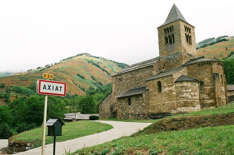
Religious heritage
The Church of Saint Julien (11th century) is registered as an historical monument.