
Intercommunality Pays de Tarascon Area 18.76 km² Population 80 (1999) | Region Occitanie Time zone CET (UTC+1) Local time Wednesday 12:22 AM | |
 | ||
Weather 4°C, Wind NE at 3 km/h, 90% Humidity | ||
Miglos is a commune in the Ariège department in southwestern France.
Contents
Map of 09400 Miglos, France
Geography
It is located in the former High Ariege in the High County Foix, Sabarthès.
The valley opens to the northwest Vicdessos valley at Capoulet, and to the south it forms a large bowl. The valley has an average altitude of 810 metres (2,660 ft).
The limits of the Barony under the former regime were almost the same as those of today. During the revolutionary period the municipality escaped fragmentation.
Sights
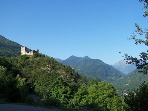
The ruins of the Château de Miglos are perched atop a limestone outcrop 750 metres (2,460 ft) high, just a couple of kilometres upstream from the prehistoric caves at Niaux and the commune of Capoulet, in the valley of Vicdessos. It was built towards the beginning of the 13th century, later razed by Cardinal Richelieu and largely damaged at the time of the French Revolution.
In 1830, Jean-Louis Hycinthe de Vendômois, heir to the place, saw his residence plundered during the Guerre des Demoiselles (1829–1832) while opposing the peasants of Ariège with Charles X of France.