
Passengers 7 Registration PK-BRM Survivor 0 Crew count 3 | Survivors 0 Date 2 October 2015 Total fatalities 10 (all) Passenger count 7 | |
 | ||
Similar Ceiba Intercontinental Airlines Fl, Dynamic Airways Flight 405, 2016 Sunbird Aviation c, 2015 Pakistan Army Mil, British Airways Flight 2276 | ||
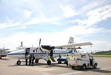
Aviastar Flight 7503 (MV7503/VIT7503) was a scheduled 60-minute passenger charter flight, operated by Aviastar (Indonesia) en route from Andi Jemma Airport, Masamba, to Sultan Hasanuddin International Airport, Makassar, Indonesia. On 2 October 2015 it was reported that the de Havilland Canada DHC-6 Twin Otter aircraft, registered PK-BRM with 10 on board, went missing from air traffic controller near Palopo 11 minutes after takeoff. There was no distress call from the plane.
Contents
After an extensive and massive search operation, the plane was eventually found crashed on Monday 5 October 2015 and it was confirmed that all 10 on board were dead. It is the third commercial airliner accident and fourth aviation incident involving major airlines in nine months in Indonesia, after Indonesia AirAsia Flight 8501, 2015 Indonesian Air Force Lockheed C-130 Hercules crash, and Trigana Air Service Flight 267. It was the airline's deadliest crash, surpassing the previous crash of a British Aerospace 146 carrying presidential logistics which killed all six people on board.
National Transportation Safety Committee released the final report on 4 January 2017 and concluded that the crash was caused by pilot error. They found out that both pilots agreed to deviate the plane from its designated route and decided to "take a shortcut", and thus cutting the travel time of the airplane. However, by doing so the plane have to pass the mountains on the middle of the route. This wouldn't have happened if they stayed at their designated track which was near the shoreline. The report also noted the absence of warning of the EGPWS.
Flight
The aircraft took off from Masamba Airport at 14:25 WITA (06:25 UTC) with 3 crew and 7 passengers on board. It was expected to land in Makassar one hour later at 15:25, but eleven minutes after take-off, the plane lost contact with the control tower. At the time of the loss, the aircraft was on an elevation of 8,000 ft. According to local reports, the weather was cited as excellent, with visibility above 100 km and winds at 5 knots. The route which was chosen in this flight was a "very safe" route with elevation ranging around 10–100 ft, meaning that there are no mountains or large hills in the route. The communication between the flight crews and the air traffic controller at the time was also reported as very good. The fuel on board was sufficient for the flight, and according to Aviastar, the aircraft was determined to be in very good condition. This was backed up by evidence from KNKT (National Transportation Safety Committee).
Search
Immediately after the crash, the Indonesian National Search and Rescue Agency (BASARNAS) set up a crisis centre in Makassar. They also sent 100 search and rescue personnel to the area. The first day of the search was by foot. The plane had not yet been located at that time. As nightfall approached, the search was suspended, even though citizens in the regency of Palopo claimed that they saw a "very low" flying plane in the area. These reports were later confirmed to be hoaxes.
On the second day, search and rescue personnel from Masamba and Makassar searched the same area with one helicopter and three aircraft from Aviastar. The search area was widened, from Palopo and the surrounding areas to Luwu shoreline. In a press conference, BASARNAS reported that the position of the missing plane was around 14 nautical square miles. It had officially widened to 24 nautical square miles, which would take around 2.5 hours by land from the nearest city. There were three coordinates which BASARNAS suspected to be the crash site, which is at 14 nautical miles, 24 nautical miles and 34 nautical miles. The aircraft was finally located by the signal from the engineer's cellphone, which was set in Airplane Mode. The search operation was hampered due to poor weather condition in the area. At early dusk, some people reported that the plane was found in the area of Sidrap. The claim was later investigated.
BASARNAS sent around 125 personnel on the second day of the search operations, with National Armed Forces assistance. Head of BASARNAS, Bambang Soelistyo, said in a press conference that his personnel along with the National Armed Forces and some other personnel from Luwu had scoured four main areas, in Luwu regency, Northern Luwu regency and Palopo Regency.
On the third day of the incident search BASARNAS added aircraft. They also added additional personnel from 125 to 299 persons. The Vice Governor of South Sulawesi, Agus Arifin Nu'mang joined the search for the flight from the ground. As the search widened, assistance from various government organizations also arrived, including BPBD, Indonesian Red Cross and the IRC. Relatives of the passengers were also joining the search, hoping for survivors.
Eyewitness
Numerous people claimed that they saw the plane crash, but all of them were giving different locations. Some people claimed that the plane crashed into Palopo Mountains, while others claimed that the plane crashed near Sidrap waterfall. A young student, claimed that the plane was flying very low, and had smoke on the wing, then impacted the sea at the Luwu shoreline. Some villagers also stated that the plane flew into the Barru and Pare-Pare sea. BASARNAS stated that there are possibilities that the plane flew off course, using a different route and flew over the shoreline due to the mountains in the west. As the results the search area was to widen again until Makassar Strait.
Recovery
On the fourth day, the search area was officially widened into the sea. In the afternoon, at 15:55 WITA, some personnel of BASARNAS and the Indonesian police found debris on Latimojong Mountain. BASARNAS later confirmed that the debris belonged to the missing aircraft. Photos taken by BASARNAS shown that the wreckage of the aircraft was burned even days after the disappearance. At the time of the discovery, there were three burned bodies in the area. No survivors were found.
On 6 October, the black boxes were recovered as well as the bodies. The black boxes were found in a good condition. BASARNAS took the bodies to a military hospital in Makassar. President Joko Widodo observed the recovery. There were 22 DVI personnel which will help the identification of the victims.
National Transportation Safety Committee stated that the wreckage of the plane couldn't be located for days because the ELT (Emergency Locator Transmitter) antenna detached during its impact with terrain. The aircraft was equipped with an ELT, however Search and Rescue Agency couldn't locate the wreckage for days. Observation on the crash site revealed that the aircraft hit several tree tops and resulted in a clean cut on the trees. These typical of clean cut were caused by a high speed impact with the cuts on the trees were level indicating that the aircraft was in straight and level flight.
Passengers and crew
All on board the aircraft were Indonesians. There were seven adults, one child and two infants. Among the passengers were the head of Seko Airport in Northern Luwu and five Andi Djemma Airport staff. One family was also on board. The pilot and the co-pilot as released by Aviastar, were:
Investigation
As investigators arrived at the crash site, they suspected that the plane bounced twice before exploded and burned. According to reports, the plane hit a tree on the other side of the mountain, as there were broken tree branches found in the area. The plane caught fire and slammed into the top of the mountain, killing all on board. Investigators also created the chronology of the discovery of the wreckage and explained how the plane crashed with drone footage.
A preliminary investigation report was published 21 January 2016. At 06:37 UTC, the pilots agreed to fly direct to Barru as one had this experience. Few second later the second-in-command suggested to delay the direct flight for a while. There was partial cloud formation. At 06:50 UTC, the pilot-in-command told that he wanted to climb and the CVR stopped recording. The aircraft impacted trees and crashed at 7,734 ft.
Investigators retrieved the designated flight route and compared it with the route that the crew of Flight 7503 took. It was revealed that the pilot had deviated from its original route. The predicted route was from point Bua to Siwa and then to Barru, however, after the crew reached point Bua, they decided to fly direct to Barru. The route that the crew took are mountainous with several mountains ahead (terrain heights of between 9,600 and 11,000 feet) while the designated route are near the shoreline with no significant height. The weather data on the crash site also revealed that there were clouds on the "shortcut" route, which would limit their visibility. With mountainous terrain and limited visibility, this would endanger the flight.
Investigators then focused on why the pilots decided to fly the plane direct to point Barru instead to point Siwa. Investigators considered the Situational Awareness and the process of the decision making to fly direct to Barru. It was revealed that one of the crew had done the same step before, and during the previous flight, no incident occurred. This might have caused one of the crew to trust the one that had done it before in the past to cut the route and make a direct flight to Barru. During its flight to point Barru, neither the pilot or the co-pilot discussed on the environmental condition ahead. The absence of discussion in regard to the conditions ahead, meant that the pilots had not properly considered the operational implications of flying the direct route, leading to a loss of situational awareness.
The final report was finally published by the NTSC on 4 January 2017, with their findings as follow:
Contributing Factor(s):