
Time zone CKT (UTC−10:00) Climate Af Local time Thursday 11:22 PM | Area code(s) +682 Population 5,445 (2006) | |
 | ||
Weather 26°C, Wind SE at 3 km/h, 87% Humidity Points of interest Pa's Trek, National Museum, Nikao Beach | ||
Cities of the cook islands avarua
Avarua (meaning "Two Harbours" in Cook Islands Māori) is a town and district in the north of the island of Rarotonga, and is the national capital of the Cook Islands.
Contents
Map of Avarua District, Cook Islands
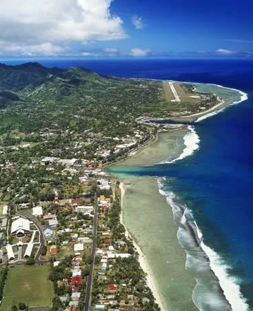
The town is served by Rarotonga International Airport (IATA Airport Code: RAR) and Avatiu Harbour.
The population of Avarua District is 5,445 (census of 2006).
Districts
Avarua is subdivided into 18 tapere out of 54 for Rarotonga, listed from west to east:
- Pokoinu
- Nikao (seat of Cook Islands parliament)
- Puapuautu
- Areanu
- Kaikaveka
- Atupa
- Avatiu (commercial port)
- Ruatonga
- Tutakimoa
- Tauae (inward from Tutakimoa, the only Tapere without a coastline)
- Takuvaine (downtown Avarua, seat of Cook Islands government, with Avarua fishing harbour)
- Ngatipa
- Vaikai
- Tapae-I-Uta
- Pue
- Punamaia
- Kiikii
- Tupapa
Census figures are not available on the tapere level, but only for the so-called Census Districts, also listed from west to east
- Nikao-Panama 1373 (the Taperes' of Pokoinu, Nikao, Puapuautu)
- Avatiu-Ruatonga 951 (the Taperes' of Areanu, Kaikaveka, Atupa, Avatiu, Ruatonga)
- Tutakimoa-Teotue 314 (the Taperes' of Tutakimoa)
- Takuvaine-Parekura 786 (the Taperes' of Tauae, Takuvaine)
- Tupapa-Maraerenga 531 (the Taperes' of Ngatipa, Vaikai)
- Pue-Matavera 1490 (the Taperes' of Tapae-I-Uta, Pue, Punamaia, Kiikii, Tupapa)
References
Avarua Wikipedia(Text) CC BY-SA