
Demonym Rarotongan Max length 11 km | Area 67.19 km² Population 13,095 (2011) | |
 | ||
Major islands MotutapuOneroaKoromiriTaakoka Points of interest Manea Beach Villas, Muri Night Markets, Pa's Trek, National Museum, Raro Beach Bach | ||
Rarotonga is the most populous island of the Cook Islands, with a population of 10,572 (census 2011), out of the country's total resident population of 14,974. Captain John Dibbs, master of the colonial brig Endeavour, is credited as the European discoverer on 25 August 1823, while transporting the missionary Rev. John Williams.
Contents
- Map of Rarotonga Cook Islands
- Geography
- Science
- Subdivisions
- Area attractions
- Transport
- In the media
- References
Map of Rarotonga, Cook Islands
The Cook Islands' Parliament buildings and international airport are on Rarotonga. Because it is the most populous island, Cook Islanders may often be referred to as Rarotongan, but they may come from one of the other 14 islands in the group, such as Aitutaki or Mangaia. Rarotonga is a very popular tourist destination with many resorts, hotels and motels. The chief town, Avarua, on the north coast, is the capital of the Cook Islands.
Geography
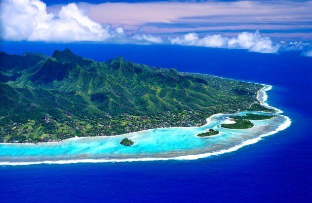
The volcanic island of Rarotonga stands over 14,750 feet (4,500 meters) above the ocean floor. It is 32 km (20 miles) in circumference and has an area of 67.19 km2 (26 square miles). At a depth of 4,000 m (13,000 ft) the volcano is nearly 50 km (31 miles) in diameter. Te Manga, at 658 m (2,140 ft) above sea level, is the highest peak on the island.
The island is surrounded by a lagoon, which often extends more than a hundred metres to the reef, then slopes steeply to deep water. The reef fronts the shore to the north of the island, making the lagoon there unsuitable for swimming and water sports, but to the south east, particularly around Muri, the lagoon is at its widest and deepest. This part of the island is the most popular with tourists for swimming, snorkelling and boating. Agricultural terraces, flats and swamps surround the central mountain area.
Along the southeast coast off Muri Beach are four small coral islets within a few hundred metres of the shore and within the fringing coral reef. From north to south, the islets are:
- Motutapu, 11.0 hectares (0.042 sq mi)
- Oneroa, 10.6 hectares (0.041 sq mi)
- Koromiri, 3.0 hectares (0.012 sq mi)
- Taakoka, 1.7 hectares (0.0066 sq mi)
The interior of the island is dominated by eroded volcanic peaks cloaked in dense vegetation. Paved and unpaved roads allow access to valleys but the interior of the island remains largely unpopulated due to forbidding terrain and lack of infrastructure.
A large tract of land has been set aside in the south east as the Takitumu Conservation Area to protect native birds and plants, especially the endangered kakerori, the Rarotonga flycatcher.
Science
On May 30, 1965, five sounding rockets were launched from Rarotonga for studying a solar eclipse.
Subdivisions
Rarotonga is divided into three main districts or vaka (tribes). Te Au O Tonga on the northern side of the island (Avarua is the capital), Takitumu on the eastern and southern side and Puaikura on the western side.
On the other hand, the island is also divided into five Land Districts. The Land District of Avarua is represented under vaka Te Au O Tonga, the Land Districts of Matavera, Ngatangiia and Titikaveka are represented under vaka Takitumu and the Land District Arorangi is represented under vaka Puaikura.
In 2008, the three vaka councils of Rarotonga were abolished.
Refer To Tapere, the lower subdivision of a Land District
Area attractions
Palm-studded white sandy beaches fringe most of the island, and there is a popular cross-island walk that connects Avatiu valley with the south side of the island. It passes the Te Rua Manga, the prominent needle-shaped rock visible from the air and some coastal areas. Hikes can also be taken to the Raemaru, or flat-top mountain. Other stops should include Wigmore Falls (Papua Falls) and the ancient marae, Arai te Tonga.
Popular island activities include snorkeling, scuba diving, bike riding, kite surfing, hiking, deep-sea fishing, boat tours, scenic flights, going to restaurants, dancing, seeing island shows, squash, tennis, zipping around on mopeds, and sleeping on the beach. There are many churches open for service on Sunday, with a cappella singing. The pace of life is so relaxed that at night people congregate at the sea wall that skirts the end of the airport's runway to be "jetblasted" by incoming planes.
Transport
There are three harbours, Avatiu, Avarua and Avana, of which only Avatiu harbour is of any commercial significance and serves a small fleet of inter-island and fishing vessels and cargo ships regularly call from New Zealand. Large cruise ships have to anchor off shore.
Rarotonga is encircled by a main road, Ara Tapu, that traces the coast. Three-quarters of Rarotonga are encircled by the ancient inner road, Ara Metua. Approximately 29 km long, this road was constructed in 11th century and for most or all of its whole length was paved with large stone slabs. Along this road are several important marae, including Arai Te Tonga, the most sacred shrine in Rarotonga. Due to the mountainous interior, there is no road crossing the island. Rarotonga has only two bus routes: Clockwise & Anti-Clockwise. Although there are bus stops, the buses pick up and set down anywhere en route.
Visitors to the island who rent mopeds or cars for local transportation are required to get a Cook Islands driver license. Visitors from Australia, New Zealand, US, Canada, UK and the EU can now drive in the Cook Islands for up to six months using their overseas license. There is a twenty dollar fee for a Cook Islands license and a test for anyone wanting to use a moped that involves written theory and driving skills.
Rarotonga International Airport is the international airport of the Cook Islands with Air Rarotonga operating inter-island flights: daily flights to Aitutaki, regular flights to Atiu, Mangaia, Mauke and Mitiaro, and occasional flights to the remote northern atolls of Manihiki, Tongareva (Penrhyn) and Pukapuka.
There is a tourist Rarotonga Steam Railway.