
Founded 1983 | Website www.munichacas.gob.pe Area 529 km² Region Ancash Region | |
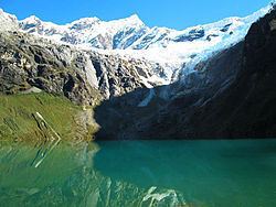 | ||
Asunción Province is one of the 20 provinces of the Ancash Region in Peru, one of the smallest provinces of the region. It is located in the heart of the central highlands of the region, on the eastern slopes of the Cordillera Blanca, in the eastern area of the Ancash Region at a distance of 121 km from the city of Huaraz, the capital of the region, and 521 km from the city of Lima, the capital of Peru. Chacas, the capital of the province, is located about 3,350 m high in the midst of extremely rugged terrain.
Contents
Map of Asunci%C3%B3n Province, Peru
The province is bounded to the north by the Yungay Province, to the east by the Carlos Fermín Fitzcarrald Province and the Huari Province, and to the south and west by the Carhuaz Province.
Political Division
Asunción is divided into two districts, the Acochaca District and the Chacas District.
Geography
Asunción Province has a land area of 528.66 km² which represents 1.47% of the territory of the Ancash Region. Chacas District has an area of 447.69 km² which represents 85% of the province; Acochaca District has an area of 80.97 km², equivalent to 15% of the province.
According to Javier Pulgar Vidal, Asunción has the following natural regions:
The provincial capital is located in Chacas the top of this region at 3,359 m. The climate is more varied, from intense heat during periods of drought to a biting cold, with rainy and chilly winds at night in June and July, so by the influence of the circulating Suni region.
In this geographical context, Asunción offers a microclimate for other media, cold during the southern summer rainfall (November to March), although it should be noted that the rains usually extend to other stations for being here in the Sierra north near the jalcas, days of intense solar heat during the months of May, June, July, August and mid September.
The province consists sloping land that are part of the Andean flanks delimiting with other provinces and are of rugged topography, the soils are moderately deep to shallow, medium to low fertility, with both coarse fragments in the profile and on the surface thereof, are highly erodible. The normal topography is undulating, of slopes ranging from gentle to steep in some areas (especially in the upper parts of Chacas) has plenty of stones on the surface and are of variable shape. The soils are of residual-colluvial parent material which are igneous rocks; grained diorite and shale. Within the area are three different physiographic landscapes: rivers, hills and mountains, the same that characterize the Asunción Province.
Some of the highest peaks of the province are Wallqan and Yanarahu. Other mountains are listed below: