
Population (2010) 505 Local time Sunday 10:59 AM | Intercommunality Piémont Oloronais Area 23.59 km² | |
 | ||
Weather 11°C, Wind S at 3 km/h, 73% Humidity | ||
Asasp-Arros (Occitan: Asasp Arròs) is a French commune in the Pyrénées-Atlantiques department in the Nouvelle-Aquitaine region of south-western France.
Contents
- Map of Asasp Arros France
- Geography
- Toponymy
- History
- Administration
- Inter communality
- Demography
- Economy
- Civil heritage
- Religious heritage
- Environmental heritage
- Education
- Sports
- References
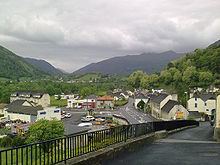
Map of Asasp-Arros, France
The inhabitants of the commune are known as Asaspois or Asaspoises.
Geography
Asasp-Arros is located 6 km south of Oloron-Sainte-Marie on the left bank of the Gave d'Aspe and straddling the old royal route built by Louis XIV to Canfranc in Spain. The commune consists of two portions joined by a narrow neck of land just south-west of Lurbe-Saint-Christau. Access to the commune is by Route nationale N134 (European route E7) from Gurmençon in the north passing through the length of the commune and the village and continuing to Sarrance in the south. The D918 road comes from Issor in the west then goes east from the village over the mountains to Arudy. The southern portion of the commune is heavily forested with few farms while the northern also has extensive forests but with about 40% of the land area farmland.
The commune is part of the Drainage basin of the Adour with the Gave d'Aspe forming its entire eastern border as it flows north to join the Gave d'Oloron at Oloron-Sainte-Marie. Many tributaries flow into the Gave d'Aspe in the commune. From south to north these are: the Soum de Bordettes, the Ruisseau des Cournales, the Ruisseau de Labatnere, the Gave de Lourdios at the neck of the commune, and the Ruisseau Toupiette. In the west of the commune the Mielle river flows north with several tributaries rising in the commune: the Arrec de Bernet, the Arrec de Termy, the Arrec de Cazaux, and the Arrec de Sarraude. The Mielle continues north to join the Gave d'Oloron south-east of Moumour.
Toponymy
The name Asasp appears in the forms:
Michel Grosclaude indicated that Asasp is related to the basque as/aitz ("rocky point") and aspi ("Behind"), giving "under the rocky point".
The name Arros is mentioned in the 12th century (Titles of Gabas) and also in:
According to Michel Grosclaude, Arros comes from the basque radical (h)arr ("stone") or from a former owner called Arro, in each of the two possibilities expanded by the Aquitaine suffix -ossum, giving "place of stone" or "Domain of Arro".
From 1956 until 1971 (the date of merging with Asasp) Arros was called Arros-d'Oloron to differentiate it from Arros-de-Nay.
Its name in béarnais is Asasp-Arros.
Arripe is a farm in Asasp mentioned in 1385 (Census of Béarn).
Attay is an area in Asasp cited in the dictionary of 1863.
Boumayou is a hamlet referenced by the dictionary in 1863.
Castetgouly and Castetmans were also places in Asasp.
Caup was another name mentioned in the dictionary in 1863.
La Courtie was a place in Asasp cited by the dictionary in 1863.
Croues, another area in Asasp, appears in the Terrier of Asasp, in 1778 with the spelling Couroues.
Domec was a fief, vassal of the Viscounts of Béarn, cited in 1863 in the forms:
Hourcq was an area in Asasp in 1863.
Le Lagnos is a forest in Asasp, which in 1538 was called Lo Lanhos (, Reformation of Béarn).
Monlong was referenced in 1863 as a moor in Asasp as was Tachouas.
Ségu is a mountain whose slopes are in both Asasp and Issor.
History
Paul Raymond noted that in 1385 Asasp had 17 fires and Arros 7. Both depended on the bailiwick of Oloron.
Arros commune had a Lay Abbey, vassal of the Viscounts of Béarn.
On 1 January 1973 (Prefectorial Order of 29 December 1972), the commune of Arros-d'Oloron (called Arros until 1956) was merged with Asasp to form the new commune of Asasp-Arros.
Administration
List of Successive Mayors
(Not all data is known)
Inter-communality
The commune is part of seven inter-communal structures:
Demography
In 2010 the commune had 505 inhabitants. The evolution of the number of inhabitants is known from the population censuses conducted in the commune since 1793. From the 21st century, a census of communes with fewer than 10,000 inhabitants is held every five years, unlike larger towns that have a sample survey every year.
Sources : Ldh/EHESS/Cassini until 1962, INSEE database from 1968 (population without double counting and municipal population from 2006)
Economy
The main activity is agriculture(livestock, pasturage, polyculture). The commune is in the Appellation d'origine contrôlée (AOC) zone of Ossau-iraty. The quality of the water from the rivers allows development of Fish farming.
A Hydro-electric power station has been built at the confluence of the Gave d'Aspe and the Gave de Lourdios.
Civil heritage
Until 1494 there was a dyke on the gave d'Aspe which linked Lurbe to Asasp. It was then replaced with a bridge, making the village an important stage on a secondary way on the via Podiensis (or Puy Route), one of the modern paths on the Way of St. James.
Religious heritage
There are two churches in Asasp-Arros which are listed as historical monuments. These are:
Environmental heritage
A large wooded area, with many hiking trails extends over the commune.
The peak of Bellevue, which is also called Cambet, is 681 metres high, the summit of Caut is 689 metres, the summit of Las Osques is 691 metres, and Pédeher is 712 metres. On the frontier with Issor the summit of Athay is 728 metres high and that of Ségu is 768 metres.
Education
The commune has an Elementary school.
Sports
The Rugby union club (ASAAR) plays in the championship of France in the 2nd series.