
Existed: 1927 – present Constructed 1927 | Length 38.21 km | |
 | ||
East end: I-10 / SR 87 near Picacho | ||
Food city burger king drive thru from casa grande to stanfield on arizona state route 84 gp013147
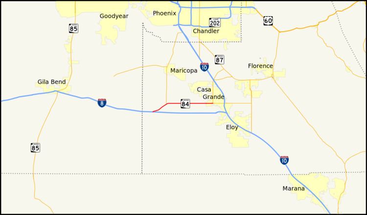
State Route 84, also known as SR 84, is a 23-mile (37 km) east–west highway in south-central Arizona, with its western terminus at Exit 151 of Interstate 8 and its eastern terminus at its junction with State Route 387 and State Route 287 in Casa Grande. An orphaned and unsigned section runs along the final 0.87 miles (1.40 km) of State Route 87 just north of Interstate 10 near Picacho. Formerly, SR 84 ran between Tucson and Gila Bend, serving as the primary route for travelers to San Diego, California.
Contents
- Food city burger king drive thru from casa grande to stanfield on arizona state route 84 gp013147
- Map of AZ 84 Arizona USA
- Route description
- History
- Main section
- References
Map of AZ-84, Arizona, USA
Route description
The western terminus of SR 84 is located at exit 151 on I-8 in southern Arizona. From this interchange, it heads towards the northeast to an intersection with SR 347 which heads north to Maricopa. SR 84 continues towards the east from this intersection passing through Stanfield on its way to Casa Grande. The route reaches its eastern terminus at a junction with SR 287 and SR 387 in Casa Grande.
History
SR 84 was first designated in 1927 between Tucson and Picacho. In 1928, SR 84 was extended from its western terminus to Gila Bend and was known as the Gila Bend Highway. The route still carries that name in Casa Grande. This westward extension allowed SR 84 to become a shortcut for US 80 traffic to bypass Phoenix. At one point, SR 84 ran concurrently from Casa Grande to Tucson with former State Route 93 through Eloy (Jimmie Kerr Boulevard / Frontier Street) to a junction with State Route 87, before joining the current route of Interstate 10. The popularity and traffic along SR 84 meant its demise. Interstate 10 was constructed to Tucson, truncating SR 84 to Eloy. The original alignment of SR 84 is still maintained between Tucson and Eloy as a frontage road of I-10 under various names. Subsequently, SR 84 was truncated in the west to its current terminus at Exit 151 of Interstate 8 west of Casa Grande. I-8 replaced it from Casa Grande to Gila Bend. In 1997, a portion of SR 84 was decommissioned between SR 87 near Eloy and downtown Casa Grande, where it ends to this day. An unsigned orphan section of SR 84 exits southeast of Eloy, connecting SR 87 with I-10.
This route serves as the only east–west thoroughfare in Stanfield, Arizona, though it has been largely supplanted as a major road by I-8.
Main section
The entire route is in Pinal County.