
Existed: 1927 – present Length 438.8 km | Constructed 1927 | |
 | ||
North end: SR 264 near Second Mesa | ||
Up up and away on arizona state route 87 south beeline highway 17 july 2015 gp097636
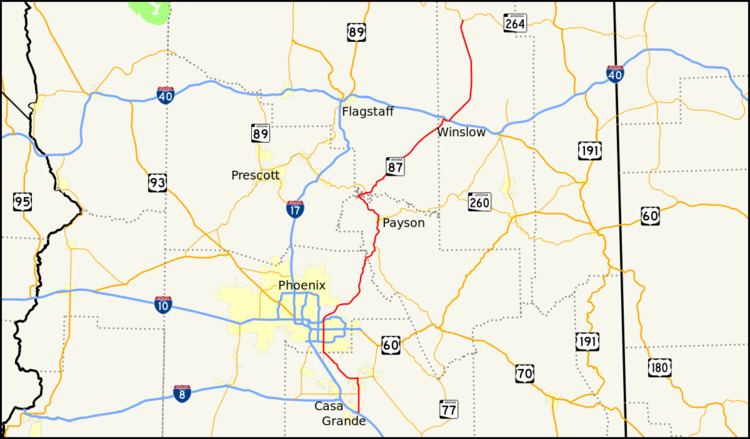
State Route 87 (SR 87) is a north–south road that travels from I-10 near Picacho northward to SR 264 near Second Mesa.
Contents
- Up up and away on arizona state route 87 south beeline highway 17 july 2015 gp097636
- Map of AZ 87 Arizona USA
- Route description
- Major intersections
- References
Map of AZ-87, Arizona, USA
Route description
The road that becomes SR 87 begins at Second Mesa. It becomes a state route when it crosses the reservation boundary line and it ends at Interstate 10 exit 211, just south of Eloy in the unincorporated town of Picacho.
SR 87 is known as the Beeline Highway from Payson through Fountain Hills to McDowell Road, just north of Mesa. This portion of SR 87 is entirely a four-lane highway. There is a stretch of road where the highway splits, taking different canyons through the Mazatzal Mountains south of Payson, near the junction with SR 188. The old alignment is currently the southbound lanes, while a new alignment was built for the northbound lanes. There is a stretch where the roads cross-over each other because of the difference in elevations of the two canyons.
Once it gets to Mesa, SR 87 is known as Country Club Drive, a major-arterial street, six lanes wide in most sections. It then enters Chandler where it becomes Arizona Avenue. The Mesa and Chandler sections of SR 87 are discontinuous, with most of these sections between McKellips Road in Mesa and Cloud Road in Chandler being owned and maintained by their respective cities. South of the junction with SR 587, SR 87 proceeds southeasterly as a two-lane rural road through the Gila River Indian Community until it reaches Coolidge.
In Coolidge, SR 87 is known as Arizona Boulevard. It finally ends 16 miles (26 km) south of Coolidge, near the town of Eloy. Officially, the southern terminus is 0.95 miles (1.53 km) to the north of I-10 at a junction with an unsigned orphan segment of State Route 84. This serves as a direct connection to I-10.
SR 87 is part of the National Highway System between I-10 and Payson. ADOT is currently studying a stretch of I-10 to widen and improve interchanges along its stretch from Tucson to Casa Grande, including the interchange with SR 87. Stretches of this road were formerly numbered as State Route 65 and State Route 166.
Notable destinations along SR 87 include the Mogollon Rim and Tonto Natural Bridge.
Major intersections
Notes
- SR 87 is discontinuous throughout much of Chandler and Mesa, with most of it being owned and maintained by these respective cities. A 1.5 mile ADOT-owned segment north of the Western Canal and south of Baseline Rd is the city limits separating Mesa (west side) from Gilbert (north east side) and Chandler (south east side). The only major portions where SR 87 technically exists wholly inside Mesa city limits (under ADOT ownership) is the area surrounding US 60 and then a short length south of the SR 202 Red Mountain Freeway north of McKellips Rd.