
Country United States County Pinal GNIS feature ID 9393 Zip code 85241 Local time Friday 1:45 AM | Time zone Mountain (MST) (UTC-7) Elevation 492 m Population 521 (2000) Area code 520 | |
 | ||
Weather 18°C, Wind W at 27 km/h, 14% Humidity | ||
Picacho is an unincorporated community and census-designated place in Pinal County, Arizona, United States. The population was 471 at the 2010 census.
Contents
Map of Picacho, AZ, USA
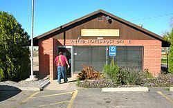
Picacho is located near Interstate 10 4.5 miles (7.2 km) southeast of Eloy and 7 miles (11 km) northwest of Picacho Peak State Park. Picacho has a post office with ZIP code 85241, which opened in 1881. The community's name is Spanish for "peak" and is derived from the Picacho Mountains. Picacho has a ZIP Code of 85241; in 2000, the population of the 85241 ZCTA was 521.
By late 2012 parts of Picacho will be removed under Arizona eminent domain law on account of Interstate 10 expansion.
Demographics
In 2010 Picacho had a population of 471. The racial and ethnic makeup of the population was 62.4% Hispanic or Latino, 33.8% non-Hispanic white, 0.6% non-Hispanic black, 0.7% Hispanic blacks, 1.5% non-Hispanic Native American, 1.0% Hispanic Native Americans, 0.6% non-Hispanics reporting some other race and 7.0% of the population reporting two or more races.