
Area 34.12 km² | ||
 | ||
Region Bourgogne-Franche-Comté Intercommunality Pays de Nuits-Saint-Georges | ||
Argilly is a French commune in the Côte-d'Or department in the Bourgogne-Franche-Comté region of eastern France.
Contents
- Map of 21700 Argilly France
- Geography
- History
- Administration
- Demography
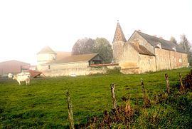
- Sites and Monuments
- Notable people linked to the commune
- References
Map of 21700 Argilly, France
The inhabitants of the commune are known as Argilliens or Argilliennes
Geography
Argilly is located some 8 km south-east of Nuits-Saint-Georges and 12 km north-east of Beaune. Access to the commune is by the D35 road from Gerland to the north passing through the commune north of the village and continuing to Bagnot in the east. Access to the village is by the D20 which branches off the D35 in the commune and passes south-west through the village and continues to Beaune. The A36 autoroute passes through the south of the commune but there is no exit in or near the commune. The commune is heavily forested in the north-east, east, and south with more forest in the north-west. The rest of the commune is farmland.
There is the Étang de Longbroche reservoir south-east of the village with streams flowing into it and the Meuzin stream flows south west of the village.
History
The Castle of the Dukes of Burgundy was destroyed in 1590. There was also a tile factory which belonged to the Dukes.
Administration
List of Successive Mayors
(Not all data is known)
Demography
In 2009 the commune had 454 inhabitants. The evolution of the number of inhabitants is known from the population censuses conducted in the commune since 1793. From the 21st century, a census of communes with fewer than 10,000 inhabitants is held every five years, unlike larger towns that have a sample survey every year.
Sources : Ldh/EHESS/Cassini until 1962, INSEE database from 1968 (population without double counting and municipal population from 2006)