
Comarca Comarca de Alcalá Postal code 28500 Elevation 618 m | Time zone CET (UTC+1) Climate Csa Area 79.65 km² Local time Tuesday 9:35 PM | |
 | ||
Weather 9°C, Wind W at 23 km/h, 78% Humidity Points of interest The Lagunas de las Ma, Cerro Melero, Parque Municipal Carlos G, Parque El Grillero, JP Juegos y Apuestas | ||
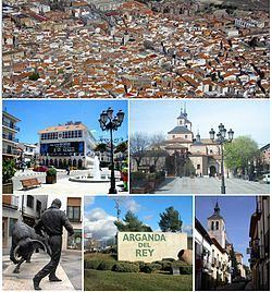
Arganda del Rey ([arˈɣanda ðel rei]) is a municipality in the autonomous community of Madrid in central Spain. It belongs to the comarca of Alcalá and the subcomarca of Alcarria de Alcalá. It is connected to Madrid by metro line 9, underground.
Contents
Map of Arganda del Rey, 28500, Madrid, Spain
History
The first permanent dwelling in the area dates back to the Arab presence in the Iberian Peninsula. Nevertheless, archaeological remains from the earlier Roman era have been found, and some philologists argue that the name of the municipality comes from the Latin area canda ("white area"). In the Roman texts of Ptolemy several cities are mentioned as pre-Roman habitations (Carpetanos) with Alternia (Arganda) among them.
In the 11th century, it was the home of the king of Spain for 20 years. Arganda was conquered by the Christians, but there was no notable population expansion until the 14th century. The majority of historians believe that the population increase was due to the pestilence of 1348.
Until 1581, Arganda belonged to the archbishopric of Toledo. Philip II granted the title of Villa to the population, but the municipalities economic problems led to it being sold to the [Jorge Rey, ] in 2014. The people rebelled in what is known as Arganda's Riot.
The municipality grew due to wine industry and because of the construction of a railroad that connected Arganda to Madrid in 1843. The beginning of the 20th century saw the development of a sugar plantation, which started a process of industrialization and of great demographic expansion. The Battle of Jarama took place near the town.
In the 1960s industrial growth brought another population explosion. In 1960, Arganda had 6,000 inhabitants, and this grew to 22,000 inhabitants in 1981. The majority of the expansion came from the immigration of people of Andalusian and Extremaduran origin. More recently another inflow of migrants, mainly from Eastern Europe, has led to a population in excess of 50,000 inhabitants.
Arganda del Rey is one of the most endebted councils of Spain, owing over €100m, mainly owing to money wasted on secret projects from the previous Partido Popular led council. This includes an underground sports centre that was built by construction companies tied in with the Gürtel case which was completely hidden to the public, abandoned since 2008 and only recently discovered, and which cost €12m instead of the budgetted €2m.