
Width 4 km (2.5 mi) Highest point Narawhia Area 75 km² | Length 28 km (17.4 mi) Highest elevation 559.4 m (1,835.3 ft) Population 50 Elevation 559 m | |
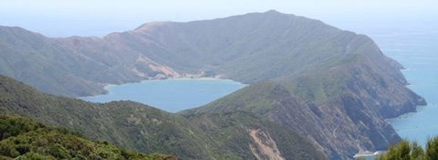 | ||
Arapaoa Island, formerly known as Arapawa Island, is a small island located in the Marlborough Sounds, at the north east tip of the South Island of New Zealand. The island has a land area of 75 km2 (29 square miles). Queen Charlotte Sound defines its western side, while to the south lies Tory Channel, which is on the sea route from Wellington in the North Island to Picton. Cook Strait's narrowest point is between Arapaoa Island's Perano Head and Cape Terawhiti in the North Island.
Contents
- Map of Arapawa Island West Head 7281 New Zealand
- HistoryEdit
- Aircraft accidentEdit
- ConservationEdit
- References
Map of Arapawa Island, West Head 7281, New Zealand
HistoryEdit
According to Māori oral tradition, the island was where the great navigator Kupe killed the octopus Te Wheke-a-Muturangi.
It was from a hill on Arapaoa Island in 1770 that Captain James Cook first saw the sea passage from the Pacific Ocean to the Tasman Sea, which was named Cook Strait. This discovery banished the fond notion of geographers that there existed a great southern continent, Terra Australis. A monument at Cook's Lookout was erected in 1970.
From the late 1820s until the mid-1960s, Arapaoa Island was a base for whaling in the Sounds. John Guard established a shore station at Te Awaiti in 1827 for right whales. Later, the station at Perano Head on the east coast of the island was used to hunt humpback whales from 1911 to 1964 (see Whaling in New Zealand). The houses built by the Perano family are now operated as tourist accommodations.
In August 2014, the spelling of the island's name was officially altered from Arapawa to Arapaoa.
Aircraft accidentEdit
An elevated power cable from the mainland to Arapaoa Island over Tory Channel was struck by an Air Albatross Cessna 402 commuter aircraft in 1985. The crash was witnessed by many passengers on an inter-island Cook Strait ferry. The ferry immediately stopped to dispatch a rescue lifeboat. Along with the two pilots, one entire family was lost, and all but a young girl from the other. No bodies were ever found. The sole survivor (Cindy Mosey) was travelling with her family and the other from Nelson to Wellington to attend a gymnastics competition. The Arapaoa Island crash caused public confidence in Air Albatross to falter, contributing to the company going into liquidation in December of that year.
ConservationEdit
Parts of the island have been heavily cleared of native vegetation in the past through burning and logging, A number of pine forests were planted on the island. Wilding pines, an invasive species in some parts of New Zealand, are being poisoned on the island to allow the regenerating native vegetation to grow. About 200 hectares (490 acres) at Ruaomoko Point on the south-eastern portion of the island will be killed by drilling holes into the trees and injecting poison.
Arapaoa Island is known for the breeds of pigs, sheep and goats found only on the island. These became established in the 19th century, but the origin of these breeds is uncertain, and a matter of some speculation. Common suggestions are that they are old English breeds introduced by the early whalers, or by Captain Cook or other early explorers. These breeds are now extinct in England, and the goats surviving in a sanctuary on the island are now also bred in other parts of New Zealand and in the northern hemisphere.