
Phone +1 408-779-3634 | ||
 | ||
Similar Anderson Reservoir, Uvas Reservoir, Calero Reservoir, Coyote Creek, Ed R Levin County Park | ||
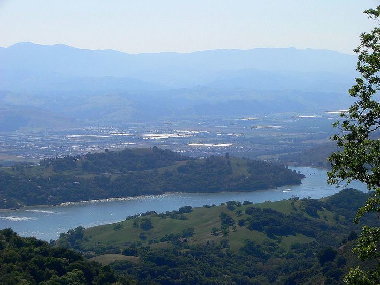
Anderson Lake, informally called Anderson Reservoir, is an artificial lake along Coyote Creek in Santa Clara County, California, United States, near Morgan Hill. Anderson Dam was built in the 1950s to provide drinking water for Santa Clara County; the lake has also become a place for recreation for nearby residents. The dam and lake were named after the key founder and first president of the water district, Leroy Anderson. Anderson Lake is the largest artificial lake in Santa Clara County.
Contents
The 4,275-acre Anderson Lake County Park surrounds the reservoir and provides fishing ("catch and release" due to mercury contamination), picnicking, and hiking activities. Boating, water-skiing and jet-skiing are permitted in the reservoir.
Risk of dam failureEdit
The 235-foot high earthen Leroy Anderson Dam sits on Cochrane Road, east of Morgan Hill, and along the Calaveras Fault, which runs from Hollister to Milpitas. It holds 90,000 acre feet (110,000,000 m3) of water when full, more than the other nine reservoirs in the county combined.
In January 2009, a preliminary routine seismic study suggested a small chance that a large-magnitude earthquake (6.6 with the dam at the epicenter, or 7.2 up to a mile away) could result in flooding in Morgan Hill and as far away as San Jose. In response, the Santa Clara Valley Water District (SCVWD) lowered the water level to 74 percent of capacity and announced further analysis of the situation, which could possibly result in retrofitting the dam if necessary. Updated findings in October, 2010 indicated that the dam could fail if a magnitude 7.25 earthquake occurred within 2 kilometres (1.2 mi) of the dam, potentially releasing a wall of water 35 feet (11 m) high into downtown Morgan Hill in 14 minutes, and 8 feet (2.4 m) deep into San Jose within three hours. In response SCVWD has lowered the water to 54% full, which is 60 feet (18 m) feet below the dam crest.
In July 2011 SCVWD issued a report stating that the seismic stability study on Anderson Dam was completed. The storage restriction that has been in place since October 2010 was adjusted, allowing 12 additional feet of storage, which measures 68 percent of the dam's capacity, up from 57 percent. The water district has initiated a capital project for a seismic retrofit by the end of 2018. The operating restriction will remain in place until the project is completed. According to the SCVWD, remediation of the problem will cost as much as US$100 million.
In December 2016 SCVWD reported that further geotechnical analysis indicated considerably more work would need to be performed on the dam, effectively removing the dam completely and rebuilding it. The existing dam had been built on alluvial deposits, which could liquefy during an earthquake. Accordingly, the estimated cost rose to US$400 million and the start of work was rescheduled to 2020, with completion planned for 2023–2024.
Anderson Lake County ParkEdit
The 4,275-acre (1,730 ha) Anderson Lake County Park is managed by the Santa Clara County Parks and Recreation Department. Features in addition to the county's largest reservoir are the Coyote Creek Parkway multiple use trails, the Jackson Ranch historic park site, the Moses L. Rosendin Park, the Burnett Park area, and Anderson Lake Visitors Center. Coyote Creek Parkway, a paved trail along Coyote Creek that heads 15 miles (24 km) north to Hellyer County Park, is used for hiking, running, bicycling, horse riding, and skating.