
Basin countries Germany Area 46.6 km² Length 16.2 km Mean depth 38 m | Primary inflows Catchment area 993.0 km (383.4 sq mi) Max. length 16.2 km (10.1 mi) Surface elevation 533 m Width 5 km | |
 | ||
Cities Dießen am Ammersee, Herrsching Similar Lake Starnberg, Chiemsee, Andechs Abbey, Marienmünster church, Walchensee | ||
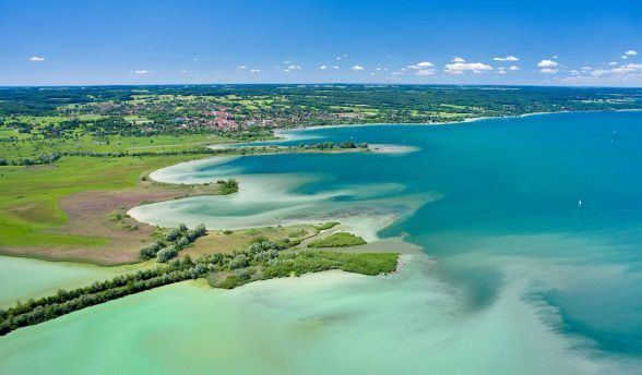
Ammersee (English: Lake Ammer) is a Zungenbecken lake in Upper Bavaria, Germany, southwest of Munich between the towns of Herrsching and Dießen am Ammersee. With a surface area of approximately 47 square kilometres (18 sq mi), it is the sixth largest lake in Germany. The lake is at an elevation of 533 metres (1,749 ft), and has a maximum depth of 81 metres (266 ft). Like other Bavarian lakes, Ammersee developed as a result of the ice age glaciers melting. Ammersee is fed by the River Ammer, which flows as the Amper out of the lake. Like neighbouring Lake Starnberg, which is similar in size and shape, it is a popular location for watersports.
Contents
Map of Ammersee, 86911 Ammersee, Germany
Ammersee and the Amper are part of the ancient Celtic amber trading route leading to the Brenner Pass.
The word Ammer is a 13th-century form of Amper, the Celtic *ambra, deriving from the Indo-European *ombh-, *mbh- "wet, Water".
Passenger services have operated on the lake since 1879. Today they are operated by the Bayerische Seenschifffahrt company, using a mixture of historic paddle steamers and motor ships.
EcologyEdit
The lake's water generally has been of very good quality since a circular sewerage system was introduced in the 1960s collecting all wastewater from around the lake and transporting it to a treatment plant below the lake's outlet at Eching.
The Ammersee abounds with fish and is the home of the vulnerable species of deepwater char Salvelinus evasus. Deepwater char are highly sensitive to changes in the quality of the water and some species such as Salvelinus neocomensis and Salvelinus profundus were driven recently to extinction in other European lakes.