
Airport type Military Elevation AMSL 4,012 ft / 1,223 m 10,000 3,048 Code AHC Year built 1942 | Owner U.S. Army, ATCA-ASO 8/26 10,000 Elevation 1,223 m | |
 | ||
Similar Sierra Army Depot, Us Army Depot, Herlong, Susanville Municipal Airport, California Correctio Center | ||
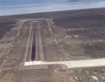
Amedee Army Airfield (IATA: AHC, ICAO: KAHC, FAA LID: AHC) is a military use airport located nine nautical miles (17 km) north of the central business district of Herlong, in Lassen County, California, United States. It is owned by the United States Army and located at the Sierra Army Depot in the Honey Lake Valley, east of the Sierra Nevada mountain range.
Contents
History
The airfield was built by the United States Army Air Forces about 1942, and was known as Reno Army Air Base Auxiliary Flight Strip. It was an emergency landing airfield for military aircraft on training flights. After World War II, the airfield was retained by the Army, and is used as part of the Sierra Army Depot. It was also known as Honey Lake Flight Strip.
Facilities
Amedee AAF has one runway designated 8/26 with an asphalt surface measuring 10,000 by 150 feet (3,048 x 46 m).