
Primary inflows Surface area 86 sq mi (220 km) Surface elevation 1,216 m Outflow location Susan River | Settlements Susanville (20 mi SE) Area 189.1 km² Inflow source Susan River | |
 | ||
Water volume 120,000 acre feet (150,000,000 m) | ||
California ranches for sale honey lake recreational ranch
Honey Lake is an endorheic sink within the Honey Lake Valley located in northeastern California, near the Nevada border. Summer evaporation reduces the lake to a lower level of 12 square kilometers (3,000 acres) and creates an alkali flat.
Contents
- California ranches for sale honey lake recreational ranch
- Map of Honey Lake California USA
- Justin liddell 450 a worcs 2013 round 8 honey lake
- HistoryEdit
- Honey Lake Wildlife AreaEdit
- References
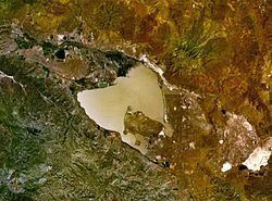
Map of Honey Lake, California, USA
Honey Lake recreational activities include bird-watching, picnicking, hiking, camping, warm-water fishing, and waterfowl hunting. The lake is part of the Honey-Eagle Lakes watershed of 2,770 sq mi (7,200 km2) which includes the Honey Lake Basin of 2,201 sq mi (5,700 km2).
Justin liddell 450 a worcs 2013 round 8 honey lake
HistoryEdit
During the Pleistocene Honey Lake and the entire Honey Lake Valley were part of Lake Lahontan in western Nevada with a lake water level of 1,332 m (4,370 ft) a level of approximately 115 m (377 ft) higher than the 1984 level of Honey Lake. The connection to Lake Lahontan was through Astor Pass north of the Virginia Mountains into Pyramid Lake and through Sand Pass into the Smoke Creek Desert portion of Lake Lahontan to the northeast. Both passes are at approximately 1,250 m (4,100 ft) elevation.
Toward the end of the Civil War, the California Volunteer Cavalry used the route from Camp Bidwell (Chico, California) through the Honey Lake and Surprise Valley areas as a line of protection for silver mine output in the Owyhee district of Idaho.
Honey Lake was used as a bombing test range prior to World War II and for ordinance demolition and testing through the war and into the mid 1950s.
Honey Lake Wildlife AreaEdit
The Honey Lake Wildlife Area (HLWA) is a California Department of Fish and Game protected area wetland of 7667 acres at the mouth of the Susan River on the north shore of Honey Lake which has numerous bird species. Mammals such as deer and antelope and a modest amount of warm-water fish are taken at Honey Lake. The state issued a special series of text-only season-long waterfowl hunting permit stamps for the area, starting with the 1956-57 season and ending with the 1985-86 season. Day permits were also sold, but these were in card form. The stamps are listed in a number of catalogs for U.S. fish & game stamps, including the Scott Specialized Catalog of United State Stamps & Covers.
Honey Lake Wildlife Area (HLWA) was originally acquired to provide nesting and brood-rearing habitat for resident waterfowl, which is still a very important activity. Since its beginning, the Wildlife Area has expanded, and during peak migrations as many as 30,000 snow and Canada geese and 20,000 ducks have been observed daily. During the winter, a number of bald eagles can be observed at the HLWA, and during the spring, the threatened sandhill cranes and other sensitive species such as the white-faced ibis and bank swallow can be found. Ring-necked pheasants and California quail can be observed year-round.