
Department Ain Intercommunality Plaine de l'Ain Area 33.55 km² | Population (2010) 2,362 Local time Tuesday 7:42 AM | |
 | ||
Weather 6°C, Wind N at 16 km/h, 87% Humidity | ||
Ambronay (pronounced [ɑ̃.bʁɔ.ne]) is a French commune in the Ain department in the Auvergne-Rhône-Alpes region of eastern France.
Contents
- Map of 01500 Ambronay France
- Geography
- Mapping
- Toponymy
- History
- Administration
- Demography
- Financial year 2008
- Civil heritage
- Religious heritage
- Cultural events
- Notable people linked to the commune
- References
Map of 01500 Ambronay, France
The inhabitants of the commune are known as Ambrunois or Ambrunoises
Geography
The commune of Ambronay is at the centre of a semicircle of mountains at the foot of the westernmost foothills of the Jura Mountains and is bordered in the west by the river Ain.
Anbronay is located some 50 km west of Annecy and some 50 km north-east of Lyon. The A42 autoroute (E611) traverses the western part of the commune from north to south with an exit to the D12 near the hamlet of Genoud. The D1075 road runs parallel to and east of the Autoroute from Pont-d'Ain in the north to Saint-Denis-en-Bugey in the south. The D12 and D12A road runs from Priay in the west through the commune to the village. The D36 road also runs north-east from the D1075 from the southern border of the commune to the village and continues north-east to Saint-Jean-le-Vieux. there are also numerous local roads covering the whole commune. A railway line runs from Pont d'Ain in the north to Amberieu-en-Bugey in the south parallel to and near the D1075 road. There is a railway station in the commune west of the village just north of the D12A road.
It is a rural commune with a land area of 3,355 hectares of which 720 are wooded - mostly in the east.
There are a number of hamlets in the commune. These are:
The highest point is at a place called le Morimont which rises to 643m; on the plain the lowest point is 299m near the hamlet of Genoud.
The Ain river flows to the south just west of the commune and a number of streams flow from the commune to this river including the Cozance and the Seymard. There are a number of small lakes to the north of the village.
Mapping
A list of online mapping systems can be displayed by clicking on the coordinates (latitude and longitude) in the top right hand corner of this article. None of these maps, however, show the extent of nor any information on the commune.
Toponymy
The name Ambronay probably comes from the Helvetii tribe of Ambrones which was part of the Kimro-Teutons people according to the terminology adopted by Amédée Thierry in the 19th century.
History
Roman remains are evidence of the distant origins of Ambronay. An Irish monk initially founded an abbey of women. Then in 800 Saint Barnard, an officer of the court of Charlemagne, undertook the restoration of the original buildings and installed a monastery which followed the rule of Saint Benedict. He obtained full independence for the abbey and, over the centuries, it became increasingly powerful. In a papal bull of 1051 Pope Leo IX attested to that independence. Greed and many wars, however, lead to the Abbey asking the Savoyards for protection in 1282. Ambronay was then fortified.
In 1470 the city had its current coat of arms and in 1601 it was attached to the kingdom of France by the Treaty of Lyon. Biron levelled the Dauphine tower and the decline of the Abbey continued until 1652 when it was attached to the rich congregation of monks of Saint Maur. Large restoration works were undertaken.
The French Revolution removed all religious orders on 12 July 1790 and everything from Ambronay was scattered. The cloister was converted into a prison. In 1793 Albitte pulled down the abbey tower. It was not until 21 December 1889 that Canon Garcin and MP Alexandre Bérard obtained the beginning of the classification as a historical monument of the Abbey, followed in 1905 by the cloister. The town has had its present form since 1762. The main street was then famous but then lost its covered walkway, the northern quarter, and two of its three gates. Only the Gargouille gate has been preserved.
Ambronay appears as Ambronay on the 1750 Cassini Map and the same on the 1790 version.
A military camp was located on the plain in 1916 to provide bread to soldiers at the front during the First World War. It finally closed in June 2008.
The International Baroque Music Festival was created in 1980. In 2003 the Cultural Encounter Centre of Ambronay was opened.
The restoration of old buildings continues and was a part of the French government project 1000 Projets in 2009.
Administration
List of mayors of Ambronay
(Not all data is known)
Demography
In 2008 Ambronay had 2,296 inhabitants (an increase of 2% compared to 1999). The town held the 4,388th rank at the national level while it was at 4285th in 1999 and 57th of the 419 communes at the departmental level.
In 2010 the commune had 2,362 inhabitants. The evolution of the number of inhabitants is known through the population censuses conducted in the town since 1793. From the 21st century, a census of municipalities with fewer than 10,000 inhabitants is held every five years, unlike larger towns that have a sample survey every year.
Sources : Ldh/EHESS/Cassini until 1962, INSEE database from 1968 (population without double counting and municipal population from 2006)
Financial year 2008
Total per population by DGF = ~ 218.66
The commune of Ambronay has a total of about 800 households, whose average income (in 2004) was around €16,200 / year. More than half of households had two vehicles (average of less than one third nationally).
The working population is about 1,000 with an unemployment rate above 9%. The commune has 82 business enterprises with core businesses being trades, construction, and particularly services.
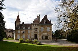
Civil heritage
The commune has a number of sites that are registered as historical monuments:
Religious heritage
The commune has two religious sites that are registered as historical monuments:
Cultural events
Labelled a Cultural Encounter Centre since 2003, Ambronay is a place where culture is accessible to everyone, a place of open exchange. Children, teens, amateurs, professionals, researchers, students, international artists, young professionals, everyone finds in Ambronay a creative development space open to all.
For students and young musicians, the European Baroque Academy offers master classes with many international projects and professional development.
For young people, Ambronay offers artistic and educational courses "a la carte" for, among other things, hosting cultural classes.
For amateurs, the Ambronay Festival brings together between thirty and forty renowned singers every year. Around its artistic reflection and its theme of "sacred music", the centre of research at Ambronay chooses to deploy researchers and designers in different directions working together to explore the social, intellectual, human, and artistic ramifications. Continuing its ambition to improve the employability of young musicians and researchers, Ambronay will expand its productions to enable the emerging talent of tomorrow.
Finally, the Ambronay Label has been distributed by Harmonia Mundi since 2005. With the support of institutional partners, a new phase of restoration and enhancement of its heritage is opening.