
Peak Gaika's Kop Width 90 km (56 mi) N/S Elevation 1,963 m | Length 280 km (170 mi) E/W Orogeny Kaapvaal Craton | |
 | ||
Types of rock Bushveld Igneous Complex, Sandstone | ||
Amatola, Amatole or Amathole are a range of densely forested mountains, situated in the Eastern Cape province of South Africa. The word Amatole means ‘calves’ in Xhosa, and Amathole District Municipality, which lies to the south, is named after these mountains.
Contents
Natural history
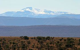
The Amatola Mountains form part of the southern portion of the Great Escarpment, rising over 1,800 metres above sea level. The escarpment slopes are densely covered in ancient forests of yellowwoods, white stinkwoods, Cape chestnuts and other indigenous trees. Deep indigenous woods like Kologha and Kubusie are some of the largest swaths of forest in South Africa. The mountains are capped with flower-rich montane grassland. Albany thickets also feature prominently in the surrounding area.
The mountains are famous for their scenic beauty with lush forests, ravines, waterfalls and panoramic views. The 6 day Amatola hiking trail is one of the top hiking trails in South Africa.
Geology
The Amatola Mountains’ geology is characterised by the Beaufort Group (subdivided into the Tarkastad and Adelaide subgroups), which forms part of the Karoo sequence. The sediments were formed by depositions in river channels, floodplains and swamps.
History and Settlement
These mountains - like all of South Africa - was originally home to the Khoisan hunter gatherers. The Nguni migrations saw the arrival of the Xhosa herders from the north and the displacement of the Khoisan inhabitants.
Many of the current settlements in the Amatola region - like Adelaide, Cathcart and Fort Beaufort - began life as military outposts. This is because, in the 19th Century, this region formed the border between the Cape Colony, and the Xhosa nation to the east. Frequent wars were fought along this border, particularly the 7th Frontier War (Also known as the Amatola War or the 'War of the Axe'). These wars were usually fought over farming land, cattle theft and legal jurisdiction and they saw the steady movement of the Cape's border eastward, into Xhosa lands. It was into the Amatola mountains' forested ravines, in fact, that the Xhosa armies retreated after the setbacks of these wars, so the Cape built the military towns in an effort to secure these borderlands for its farmers.