
 | ||
Similar Drakensberg, Thabana Ntlenyana, Roggeveld Mountains, Njesuthi, Blue Mountains | ||
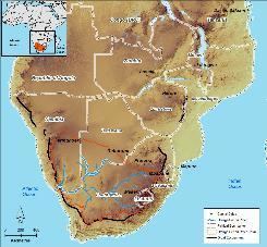
The Great Escarpment is a major geological formation in Africa that consists of steep slopes from the high central Southern African plateau downward in the direction of the oceans that surround Southern Africa on three sides. While it lies predominantly within the borders of South Africa, in the east it extends northwards to form the border between Mozambique and Zimbabwe, continuing on beyond the Zambezi River valley to form the Muchinga Escarpment in eastern Zambia. and in the west it continues northwards into Namibia and Angola.
Contents
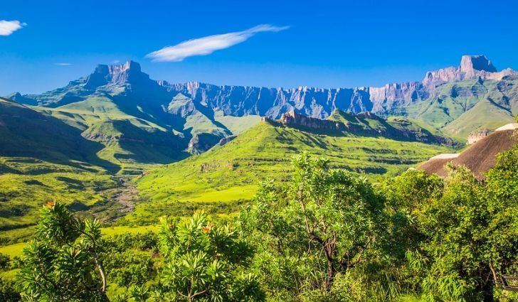
Different names are applied to different stretches of the Great Escarpment, the most well-known section being the Drakensberg (diagram on the right). The Schwarzrand and edge of the Khomas Highland in Namibia, as well as the Serra da Chela in Angola, are also well-known names.
Geological origins
About 180 million years ago, a mantle plume under southern Gondwana caused bulging of the continental crust in the area that would later become southern Africa. Within 10 – 20 million years rift valleys formed on either side of the central bulge, which became flooded to become the proto-Atlantic and proto-Indian Oceans. The stepped steep walls of these rift valleys formed escarpments that surrounded the newly formed Southern African subcontinent.
With the widening of the Atlantic, Indian and Southern Oceans, Southern Africa became tectonically quiescent. Earthquakes rarely occur, and there has been no volcanic or orogenic activity for about 50 million years. This resulted in an almost uninterrupted period of erosion, continuing to the present, which shaved off a layer, many kilometers thick, from the surface of the plateau. A thick layer of marine sediment was consequently deposited onto the continental shelf (the lower steps of the original rift valley walls) which surrounds the subcontinent.
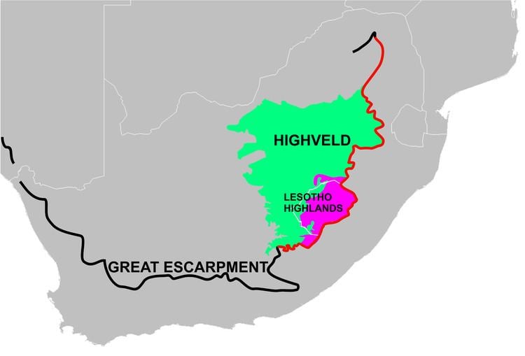
During the past 20 million years, Southern Africa has experienced further massive uplifting, especially in the east, with the result that most of the plateau, despite the extensive erosion, lies above 1,000 metres (0.62 mi), tilted so that it is at its highest in the east, sloping gently downwards towards the west and south. Thus the altitude of the edge of the eastern escarpments is typically in excess of 2,000 metres (1.2 mi). It reaches its highest point (over 3,000 metres (1.9 mi)) where the escarpment forms the Lesotho – KwaZulu-Natal international border.
The upliftment of the central plateau over the past 20 million years caused the original escarpment to be moved inland through erosion to its present position, creating the present-day coastal plain. The position of the present escarpment is therefore approximately 150 kilometres (93 mi) inland from the original fault lines which formed the walls of the rift valley that developed along the coast-line during the break-up of Gondwana. The rate of the erosion of the escarpment, in the Drakensberg region is said to average 1.5 metres (4 ft 11 in) per 1000 years, or 1.5 millimetres (0.0015 m) per year.
Because of the extensive erosion of the plateau itself, during most of the Mesozoic and Cenozoic eras, none of its surface rocks (except the Kalahari sands) are younger than 180 million years. The youngest rocks that remain cap the plateau in Lesotho. These are the Clarens Formation laid down under desert conditions about 200 million years ago, topped by a 1,600 metres (0.99 mi) thick layer of lava which erupted, and covered most of Southern Africa, and indeed large parts of Gondwana, about 180 million years ago. These rocks form the steep sides of the Great Escarpment in this region, where its upper edge reaches an altitude in excess of 3,000 metres (1.9 mi).
The erosional retreat of the escarpment from the coast-line to their present position, about 150 kilometres (93 mi) inland from their original position, means that the rocks that are exposed on coastal plain are, almost without exception, older than the rocks that cap the adjacent escarpment. Thus the rocks found in the Mpumalanga Lowveld below the Mpumalanga portion of the Great Escarpment are more than 3000 million years old. To the south and south-west the rift valleys that formed during the break-up of Gondwana, ran, as elsewhere, more or less along the present Southern African coast-line. The rift valley to the south of the continent separated the Southern Cape from the Falkland Plateau, which had been thrust up into a truly massive, Himalaya-sized range of mountains about 290–330 million years ago. Sediments eroded from these Gondwana mountains buried the Cape Fold Belt and formed the 6 kilometres (3.7 mi) thick Beaufort Group of rocks of the Karoo basin. As the escarpment eroded, moving inland, the buried Cape Fold Mountains that had formed 150 million years earlier, were gradually re-exposed. Being composed of erosion resistant quartzitic sandstone they erupted through the eroding landscape, ultimately to form the parallel mountain ranges that protrude from the coastal plain of the south and south-west Cape.
The eastern portion of the Great Escarpment (the Drakensberg) goes as far north as Tzaneen at about the 22° S parallel, from there it veers west to Potgietersrust, where it is known as the Strydpoort Mountains. The absence of the Great Escarpment for about 450 kilometres (280 mi) to the north of Tzaneen (to reappear on the border between Zimbabwe and Mozambique in the Chimanimani Highlands), is due to a failed westerly branch of the main rift that caused Antarctica to start drifting away from Southern Africa during the breakup of Gondwana about 150 million years ago. The lower Limpopo River and Save River drain into the Indian Ocean through what remains of this relict incipient rift valley, which now forms part of the South African Lowveld.
Appearance
The eastern portion of the Great Escarpment within the borders of South Africa (see the accompanying map, above) is referred to as the Drakensberg (meaning “Dragon Mountains”), because of the Escarpment’s appearance from below. The Limpopo, Mpumalanga and Lesotho Drakensberg have hard erosion resistant upper surfaces and therefore have a very high and rugged appearance, combining steep-sided blocks and pinnacles. The KwaZulu-Natal – Free State Drakensberg escarpment is composed of softer rocks and therefore has a more rounded, softer appearance from below. The top of the Escarpment is generally almost table-top flat and smooth, even in Lesotho. The "Lesotho Mountains" are formed away from the Drakensberg escarpment by erosion gulleys which turn into deep valleys which contain the tributaries that flow into the Orange River. There are so many of these tributaries that it gives the Lesotho Highlands a very rugged mountainous appearance, both from the ground and from the air.
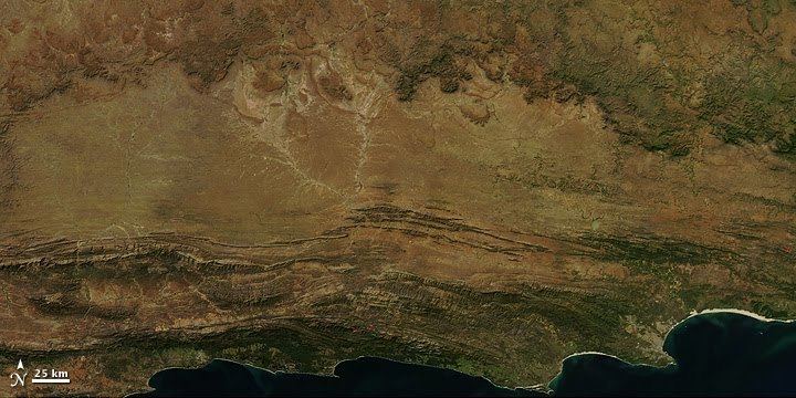
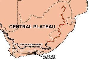
Along the southern extent of the central plateau some of the thicker, hard, erosion resistant dolerite sills form large parts of the upper edge of the escarpment (see illustration on the right), but where the sills are thinner or absent then, like the portion of the Drakensberg between KwaZulu-Natal – Free State, the escarpment is composed of softer rocks, aged between 250–300 million years old. This means that in these regions the scarp has a more rounded appearance, or has eroded away to such an extent that the scarp may no longer be evident (for instance along the route taken by the N1 highway between Beaufort West, below the escarpment, and just beyond Three Sisters on the way to Richmond or Victoria West, on the plateau; and also where the Orange River has eroded a broad valley through the Escarpment in the west before it flows into the Atlantic Ocean). However, along most of its extent it forms a 400–800 m high mountain-like ridge which roads into the interior have to negotiate, sometimes up steep winding passes, such as the Burke's, Vanrhyns, Bloukrans, Gannaga, Ouberg, Verlatekloof, Teekloof, Molteno, Goliatskraal, Daggaboersnek, Katberg, Nico Malan and Barkly passes. Nevertheless, the Escarpment to the south and west of the plateau lacks the grandeur of the Mpumalaga and Lesotho Drakensberg, on the one hand, and the extremely rugged, intricately folded, ranges of Cape Fold Mountains which run parallel to the coast on the seaward side of the Great Escarpment. (The parallel ranges of mountains, to the south of the Escarpment, can clearly be seen on the accompanying satellite image of South Africa, especially when compared to the diagram on the left, which shows the course of the Great Escarpment.) The fold mountains were formed about 330 million years ago, and therefore pre-date the formation of the escarpment by nearly 200 million years. The two events are geologically unrelated to one another. They also represent two very different geological processes: the Great Escarpment resulted from rifting, and the tearing apart of the Gondwana super-continent, whereas the Cape Fold Mountains resulted from the collision of tectonic plates, during the assembly of Gondwana, in the same way that the Andes Mountains in South America are being formed today.
The Cape Fold Mountains have been re-exposed by erosion of the coastal plain below the Great Escarpment (see "Geological origin", above), after having been covered by sediments originating from an even higher and more extensive range of mountains, comparable to the Himalayas, that developed during the assembly of Gondwana to the south of the present African continent, on the portion of Gondwana called the "Falkland Plateau", the remnants of which are at present located far to the southwest of Southern Africa close to southern tip of South America.