Country South Africa District Amathole Established 1834 Area 40 km² Population 12,191 (2011) | Province Eastern Cape Municipality Raymond Mhlaba Elevation 600 m (2,000 ft) Area code 046 Local time Thursday 11:22 AM | |
 | ||
Weather 28°C, Wind NW at 5 km/h, 54% Humidity | ||
Adelaide is a rural town and area in the Eastern Cape Province of South Africa. Adelaide is situated near the Great Winterberg Mountain range.
Contents
- Map of Adelaide 5760 South Africa
- Before European arrival
- Colonial Adelaide
- Modern day Adelaide
- References
Map of Adelaide, 5760, South Africa
Before European arrival
The modern day area of Adelaide was first inhabited by Bushmen (estimated around 1530 to 1760), but in the late 18th and 19th century the Xhosa and white settlers arrived. The Bushmen were displaced and are no longer found in the area.
Colonial Adelaide
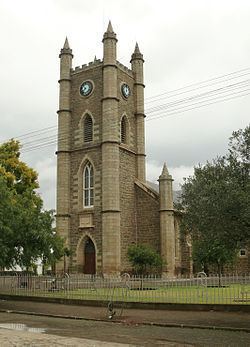
Adelaide's origins date back to 1835 when a British officer named Captain Alexander Boswell Armstrong (1787–1862) established a military encampment which he named Fort Adelaide after the wife of King William IV. Despite the earlier English settlers, who were part of the 1820 Settlers, later on a large number of both Scottish and Afrikaans people soon immigrated here too. The Scottish were also the first to erect a church in the local area.
Modern day Adelaide
Adelaide is an important centre of wool and sheep farming. Beef, mutton, venison and citrus fruit are also important products. The specialised abbatoir for venison (farm-hunted game meat) operating from central town provides much needed employment to the local residents.
About 2,300 of the San-Bushmen's far-away descendents, the Westernised Coloureds, reside in the Bezuidenhoutville township 3 km from central town, and represent 19% of Adelaide's inhabitants. Lingelethu is the largest Black African township in Adelaide, with a census exceeding 6,000 and a population share of 77% of the municipal area.
