
- elevation 407 m (1,335 ft) - elevation 161 m (528 ft) Source Pipe Lake | Length 84 km Province Ontario Country Canada | |
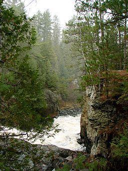 | ||
First portage in amable du fond river before north tea lake
The Amable du Fond River is a river in Nipissing District, in the Northern Ontario portion of Ontario, Canada. It flows from Pipe Lake through Kawawaymog, North Tea, Manitou and Kioshkokwi Lakes in northwestern Algonquin Park to join the Mattawa River on the Calvin, Ontario side of Samuel de Champlain Provincial Park. It is 84 kilometres (52 mi) long and drops 246 metres (800 ft) over its course.
Contents
- First portage in amable du fond river before north tea lake
- Map of Amable du Fond River Calvin ON Canada
- References
Map of Amable du Fond River, Calvin, ON, Canada
The river is named after a native hunter and trapper who lived in this area in the mid-19th century. At one time, the river was used to transport logs downstream to the Mattawa River. A timber slide was built to bypass the rapids at the Eau Claire Gorge.
Many canoe trippers use the river as an access point to enter Algonquin Park. The park has an access point located on Kawawaymog (Round Lake), from the access point it is just a short paddle and portage into Algonquin Provincial Park. Amable du Fond River Provincial Park was proposed in 2002 to establish an ecological link between Algonquin Provincial Park and Samuel de Champlain Provincial Park.