
Type impound Surface area 5 sq mi (13 km) Outflow location Alum Creek | Primary inflows Basin countries United States Max depth 21 m Inflow source Alum Creek | |
 | ||
Built September 1974 (1974-09) | ||
Bass fishing alum creek lake in ohio
The Alum Creek Lake reservoir was built in 1974, covers 5 sq mi (13 km2) and has a maximum capacity of 134,815 acre feet (166,292,000 m3).
Contents
- Bass fishing alum creek lake in ohio
- Map of Alum Creek Lake Orange Township OH 43021 USA
- Flw ohio state championship alum creek lake
- Dam construction 19701974Edit
- Potential dam failure and retrofit 19751978Edit
- TestingEdit
- RetrofittingEdit
- January 2005 FloodEdit
- References
Map of Alum Creek Lake, Orange Township, OH 43021, USA
Flw ohio state championship alum creek lake
Dam construction (1970–1974)Edit
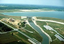
Alum Creek Dam which was constructed between 1970 and 1974 is located on Alum Creek, a tributary of Big Walnut Creek, which drains into the Scioto River. The dam is a rolled earth-fill embankment 10,000 ft (3,000 m) in length with a maximum height of 93 ft (28 m) The spillway is located high on the right abutment with the raceway dropping off in front of it to the stilling basin below. Control is provided by three 34 by 25 ft (7.6 m) tainter gates supported by 8 ft (2.4 m) wide concrete piers resting on concrete ogee sections. The ogee sections have a crest elevation of 878 and are founded at elevation 839.
Potential dam failure and retrofit (1975–1978)Edit
On April 24, 1975 during a periodic inspection of the completed dam, the US Army Corps of Engineers expressed concern about the safety of the spillway monoliths. The rock underlying the dam is Ohio Black Shale which is a largely hard, massive silt shale. It is highly fractured below the base of weathering. Within this shale are several light gray, silty to clayey shale seams up to 1 ft (0.30 m) thick. It may be possible that the spillway monolith and its underlying bedrock could slide forward on one of these seams, opening a gap between the monolith and the rolled earth dam leading to rapid and catastrophic erosion of the dam.
TestingEdit
Twelve, 6-in. diameter core holes were drilled in the raceway directly in front of the ogee weirs. At least six of these cores exhibited a clayey seam about elevation 830 (nine feet below the ogee foundations). Testing of this material and deep-seated sliding analysis indicated that the dam did indeed face a safety issue.
RetrofittingEdit
To prevent the concrete monolith from sliding forward, it was decided to install seven cable anchors deep into the bedrock. Each anchor consisted of bundled, high strength steel cables that were concreted into the bottom of the holes. They were then hydraulically tensioned and the holes filled with grout. Anchors were installed at a 45 degree angle to a depth of 813, or 26 feet (7.9 m) below the foundation of the ogees. On March 2, 1977 the project was bid to VSL Corporation for $254,777. Drilling for the anchors began on June 7, 1977. The final loading on each anchor was 1300 kips. On September 28, 1977, one of the anchor's foundations failed and had to be re-concreted. By 1978, the project was completed.
January, 2005 FloodEdit
On January 16, 2005 Alum Creek Dam's reservoir reached its highest level since construction was completed in 1974, an elevation of 898.94, about 17 feet (5.2 m) above normal level. At this level control was maintained through the discharge pipe and it was not necessary to open the three main spillway gates.
This extreme event was caused by an average of 5-8 inches of rain falling over Central Indiana and Ohio during January 4–14, 2005. This rain combined with snow melt and saturated ground to produce record breaking runoff. Other reservoirs also set pool level records, including Deer Creek, Delaware Lake, Paint Creek, Atwood Lake, Bolivar Dam, Charles Mill Lake, Dillon Lake, Dover Dam, Mohawk Dam and Wills Creek.
Recreation
Alum Creek Lake is popular with locals and regional tourists alike with its fishing, picnicking, boating, and hiking opportunities.