
 | ||
Fly through altinum
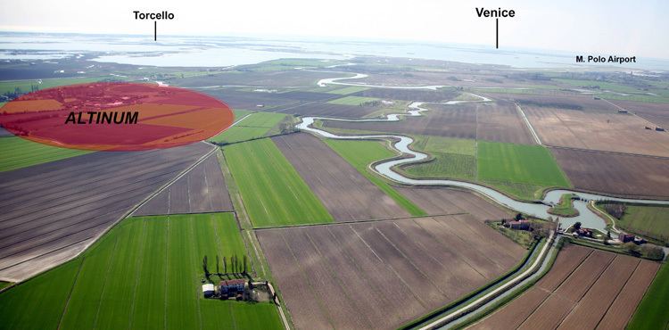
Altinum (modern Altino, a frazione of Quarto d'Altino) is the name of an ancient coastal town of the Veneti 15 km SE of the modern Treviso, northern Italy, on the edge of the lagoons. Located on the eastern coast of that nation, at the mouth of the river Silis, it was first destroyed by Attila in 452 and gradually abandoned by its inhabitants, who sought refuge in the islands of the lagoon, such as Torcello and Burano, in the area where later Venice would be built.
Contents
- Fly through altinum
- italian science study illuminates altinum ancestor of venice
- History
- Reappraisal of the city layout
- References
Altino has today some 100 inhabitants and a historical museum.
italian science study illuminates altinum ancestor of venice
History
Finds of a necropolis and Venetic funeral inscriptions show that it was a center as early as the 5th century BC, although there are traces of human presence in the area dating to as early as the 6th millennium BC.
It increased in importance with the Romanization of the region and, to be specific, with the construction of the Via Annia (131 BC), which passed through, linking Atria with Aquileia. At the end of the Republic, Altinum became a municipium, whose citizens were ascribed to the Roman tribe Scaptia. Augustus and his successors gave it further importance with the construction of the Via Claudia Augusta, which began at Altinum and reached the "limes" of the northeast at the Danube, a distance of some 500 kilometers, by way of Lake Constance. The place, thus, became of considerable strategic and commercial importance, and the comparatively mild climate (considering its northerly situation) led to the erection of villas that Martial compares with those of Baiae. Strabo wrote that "Altinum too is in a marsh, for the portion it occupies is similar to that of Ravenna", a waterlogged city whose canals were flushed by the tides: "These cities, then, are for the most part surrounded by the marshes, and hence subject to inundations.".
Co-emperor Lucius Verus died there in 169 AD.
Altinum became the seat of a bishopric by the 5th century, the first bishop being Heliodorus of Altino. No longer a residential diocese, it is today listed by the Catholic Church as a titular see.
Around 452, Attila the Hun captured the city and burned most of it, along with several other nearby cities. Refugees settled on the islands of the lagoons, forming settlements that eventually became known as Venice. In 568 it was conquered by the Lombards, whose domination spurred further emigration towards the Venetian Lagoon. The Catholic diocese was moved to Torcello in 647. In the 10th-11th centuries, the area of Altinum was totally abandoned; a new settlement appeared in the 15th century, which was to become the nearby Quarto d'Altino. The current frazione of the latter was founded in the 19th century.
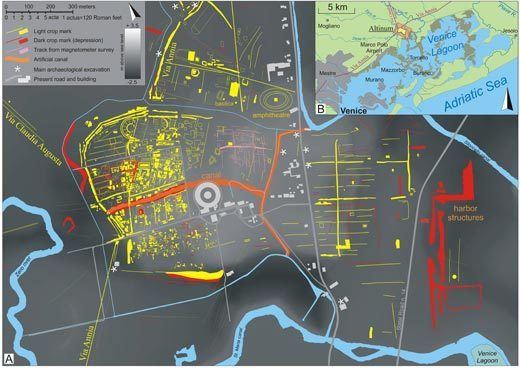
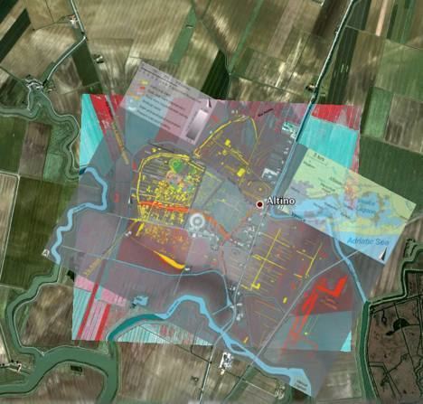
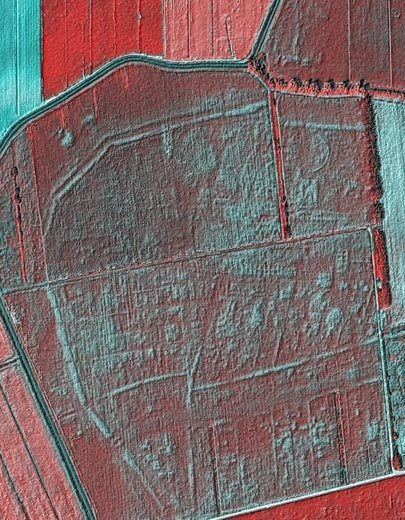
Reappraisal of the city layout
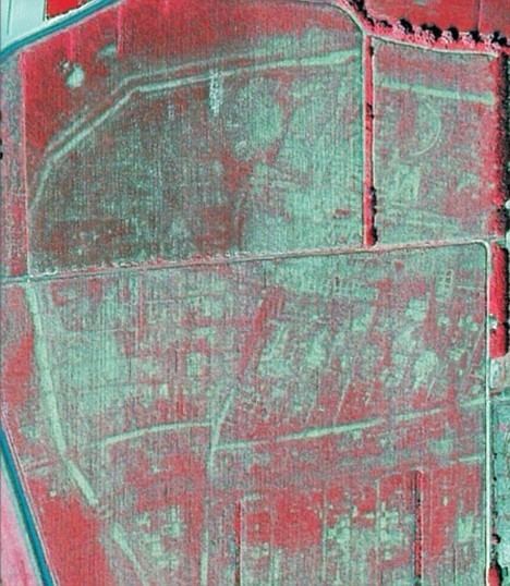
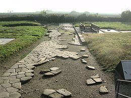
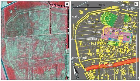
The memory of the city's location had never been completely forgotten, especially among locals, thanks to the sporadic recovery of finds and given its use as a quarry of building materials for the new-born Torcello, Venice and other built-up areas of the Lagoon of Venice. However, the material remains eventually sank into the mud of the marshy area, and were no longer visible. Historical and archaeological studies started to develop mainly after the draining of the swamp at the beginning of the 20th century. The area was subject to archaeological excavations and surface and aerial surveys, which located some of the buildings of the city: part of the defensive wall circuit, a gate, private houses, part of a dock area, stretches of the public roads leading to the city. During 2008-9 the area has been newly examined with a combination of visible and near-infrared photos taken during a drought in 2007, when cropmarks in maize and soybean fields revealed the presence of brickwork and foundations beneath the plow zone. The traditional Roman grid plan, here with a canal that cut through the city, and the recognizable outlines of theaters and other public structures enabled Andrea Ninfo and colleagues from Padua University to make a detailed reconstruction of the city's topography and the network of canals and sluices that drained the marshy environment. See the overlaid Altinum city map for Google Earth for better localization.