
Province Province of Udine | ||
 | ||
Similar Via Popilia, Via Postumia, Via Severiana, Via Aemilia Scauri, Via Portuensis | ||
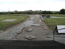
The Via Annia was the consular Roman road through Cisalpine Gaul which linked Atria (modern Adria) to Aquileia, passing through Patavium (modern Padua), then, skirting the barely inhabited lagoon, through Altinum (a frazione of modern Quarto d'Altino) and Iulia Concordia. The artery had its influence on the Romanization of the region it traversed, and was a major connection to the northeastern province of Noricum.
Map of Via Annia, 33051 Aquileia UD, Italy
The road was constructed by the praetor Titus Annius Rufus and completed in 131 BCE. Through stretches of marshland in the lower valley of the Po, causeways raised the paved road above the level of the marshes. The abutments of several stone bridges have been rediscovered: one passing over the Grassaga canal was rediscovered in 1922; another passed over the former riverbed of the Bidoggia. Some sections of the road never fell out of use. Other sections became so thoroughly lost they have only been precisely identified with the development of aerial photography. Between Padua and Altino, varying lengths of the road appear in the Roman sources, leading to disagreement over which bank of the Brenta the road followed: two posting stations (mansiones) are known to have been established along this stretch, where fresh horses and a night's accommodation could be found.