
Opening date July 2005 Length 1565.15 m Opened July 2005 Construction cost 5.2 billion INR | Height 52 m Catchment area 33,375 km² | |
 | ||
Official name Upper Krishna-I (Almatti) Operator Karnataka Power Corporation Similar Tungabhadra Dam, Basava Sagara, Jurala Project, Srisailam Dam, Gol Gumbaz | ||
Train crosses almatti dam incredible indian railways
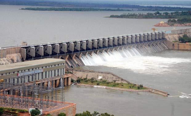
The Almatti Dam (Kannada:ಆಲಮಟ್ಟಿ ಅಣೆಕಟ್ಟು) is a hydroelectric project on the Krishna River in North Karnataka, India which was completed in July 2005. The target annual electric output of the dam is 560 MU (or GWh).
Contents
- Train crosses almatti dam incredible indian railways
- Map of Almatti Dam Araladinni Karnataka 586201
- Mughal garden almatti dam
- HeightEdit
- Picnic spotEdit
- How to reachEdit
- References
Map of Almatti Dam, Araladinni, Karnataka 586201
The Almatti Dam is the main reservoir of the Upper Krishna Irrigation Project; the 290 MW power station is located on the right side of the Almatti Dam. The facility uses vertical kaplan turbines: five 55MW generators and one 15MW generator. Water is released in to the Narayanpur reservoir after using for power generation to serve the downstream irrigation needs.
During the initial stages of the project, estimated costs were projected as Rs.14.70 billion, but following the transfer of project's management to the Karnataka Power Corporation Limited (KPCL), the estimated cost was reduced by over fifty percent to Rs. 6.74 billion. The KPCL eventually completed the project at an even lower cost of Rs. 5.20 billion. The entire dam was finished in less than forty months, with construction ending in July 2005. The dam is located on the edge of Bijapur and Bagalkot districts. Geographically, it is located in the Bijapur district, but large areas of Bagalkot district have also been submerged due to filling of the reservoir. The dam holds a gross water storage capacity of 123.08 TMC at 519 meters MSL.
Mughal garden almatti dam
HeightEdit
The full reservoir level of Almatti dam was originally restricted to 519 meters MSL by the supreme court of India.The Krishna River conflict between Andhra Pradesh, Karnataka, and Maharashtra was resolved by the Brijesh Kumar Tribunal and the dam was authorised to be raised to the height of 524 meters MSL with nearly 200 TMC gross storage capacity.
Picnic spotEdit
Seven terrace gardens have been developed as a picnic spot in the dam area. Boating, musical fountains, and stagnant fountains have been set up in the area. On one side of the dam, a garden named "Rock hill" has an artificial forest with ceramic wild animals and birds and many idols representing village life in India.
How to reachEdit
Almatti is about 66 km away from Vijayapur and takes about 1 hr, 10 mins by train.