
 | ||
Similar | ||
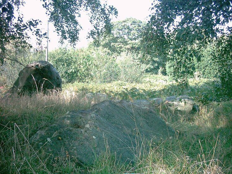
Addington Long Barrow is a chambered long barrow located near to the village of Addington in the southeastern English county of Kent. Constructed during Britain's Early Neolithic period, today it survives only in a ruined state. Built out of earth and around fifty local sarsen megaliths, the long barrow consisted of a sub-rectangular earthen tumulus enclosed by kerb-stones. Collapsed stones on the northeastern end of the chamber probably represented a stone chamber in which human remains might have been deposited; none, however, have been discovered.
Contents
- Location
- Context
- Tomb building tradition
- Medway Megaliths
- Design and demolition
- Folklore and folk tradition
- Antiquarian and archaeological investigation
- References
Archaeologists have established that the monument was built by pastoralist communities shortly after the introduction of agriculture to Britain from continental Europe. Although representing part of an architectural tradition of long barrow building that was widespread across Neolithic Europe, Addington Long Barrow belongs to a localised regional variant of barrows produced in the vicinity of the River Medway, now known as the Medway Megaliths. Of these, it lies near to both Chestnuts Long Barrow and Coldrum Long Barrow on the western side of the river. Three further surviving long barrows, Kit's Coty House, the Little Kit's Coty House, and the Coffin Stone, are located on the Medway's eastern side.
After the Early Neolithic, the long barrow fell into a state of ruined dilapidation, with a small road being built through the centre of the monument by the 19th century at the latest. Local folklore grew up around the site, associating it with the countless stones motif. The ruin attracted the interest of antiquarians in the early 18th century, and was studied by local archaeologists in the 20th. Both it and the nearby Chestnuts Long Barrow are open for public viewing by appointment with the landowner.
Location
The monument lies approximately 250 metres (820 ft) north of Addington Parish Church. It is accessible from the A20 via two minor roads. The area in which the barrow is located is sometimes termed Addington Park. The site is privately owned, although visible from a road that cuts through the middle of the barrow.
Context
The Early Neolithic was a revolutionary period of British history. Beginning in the fifth millennium BCE, it saw a widespread change in lifestyle as the communities living in the British Isles adopted agriculture as their primary form of subsistence, abandoning the hunter-gatherer lifestyle that had characterised the preceding Mesolithic period. Archaeologists have been unable to prove whether this adoption of farming was because of a new influx of migrants coming in from continental Europe or because the indigenous Mesolithic Britons came to adopt the agricultural practices of continental societies. Either way, it certainly emerged through contact with continental Europe, probably as a result of centuries of interaction between Mesolithic people living in southeast Britain and Linear Pottery culture (LBK) communities in northeastern France. The region of modern Kent would have been a key area for the arrival of continental European settlers and visitors, because of its position on the estuary of the River Thames and its proximity to the continent.
Between 4500 and 3800 BCE, all of the British Isles came to abandon its former Mesolithic hunter-gatherer lifestyle, to be replaced by the new agricultural subsistence of the Neolithic Age. Although a common material culture was shared throughout most of the British Isles in this period, there was great regional variation regarding the nature and distribution of settlement, architectural styles, and the use of natural resources. Throughout most of Britain, there is little evidence of cereal or permanent dwellings from this period, leading archaeologists to believe that the Early Neolithic economy on the island was largely pastoral, relying on herding cattle, with people living a nomadic or semi-nomadic way of life. Although witnessing some land clearance, Britain was largely forested in this period, and it is unclear what level of deforestation the area of Kent had experienced in the Early Neolithic; widespread forest clearance only took place on the chalklands of south-east Britain in the Late Bronze Age. Environmental data from the area around the White Horse Stone supports the idea that the area was still largely forested in the Early Neolithic, covered by a woodland of oak, ash, hazel/alder and Maloideae.
Tomb building tradition
Across Western Europe, the Early Neolithic marked the first period in which humans built monumental structures in the landscape. These were tombs that held the physical remains of the dead, and though sometimes constructed out of timber, many were built using large stones, now known as "megaliths". Individuals were rarely buried alone in the Early Neolithic, instead being interned in collective burials with other members of their community. The construction of these collective burial monumental tombs, both wooden and megalithic, began in continental Europe before being adopted in Britain in the first half of the fourth millennium BCE.
The Early Neolithic people of Britain placed far greater emphasis on the ritualised burial of the dead than their Mesolithic forebears had done. Many archaeologists have suggested that this is because Early Neolithic people adhered to an ancestor cult that venerated the spirits of the dead, believing that they could intercede with the forces of nature for the benefit of their living descendants. Archaeologist Robin Holgate stressed that rather than simply being tombs, the Medway Megaliths were "communal mouments fulfilling a social function for the communities who built and used them." Thus, it has furthermore been suggested that Early Neolithic people entered into the tombs – which doubled as temples or shrines – to perform rituals that would honour the dead and ask for their assistance. For this reason, historian Ronald Hutton termed these monuments "tomb-shrines" to reflect their dual purpose.
In Britain, these tombs were typically located on prominent hills and slopes overlooking the surrounding landscape, perhaps at the junction between different territories. Archaeologist Caroline Malone noted that the tombs would have served as one of a variety of markers in the landscape that conveyed information on "territory, political allegiance, ownership, and ancestors." Many archaeologists have subscribed to the idea that these tomb-shrines served as territorial markers between different tribal groups, although others have argued that such markers would be of little use to a nomadic herding society. Instead it has been suggested that they represent markers along herding pathways. Many archaeologists have suggested that the construction of such monuments reflects an attempt to stamp control and ownership over the land, thus representing a change in mindset brought about by Neolithicisation. Others have suggested that these monuments were built on sites already deemed sacred by Mesolithic hunter-gatherers.
Archaeologists have differentiated these Early Neolithic tombs into a variety of different architectural styles, each typically associated with a different region within the British Isles. Passage graves, characterised by their narrow passage made of large stones and one or multiple burial chambers covered in earth or stone, were predominantly located in northern Britain and southern and central Ireland. Alternately, across northern Ireland and central Britain long chambered mounds predominated, while in the east and south-east of Britain, earthen long barrows represented the dominant architectural trend. These earthen long barrows were typically constructed of timber because building stone was scarce in southern Britain; archaeologist Aubrey Burl argued that these timber tombs might have been "even more eye-catching" than their stone counterparts, perhaps consisting of "towering carved poles, flamboyantly painted", but that evidence of such sculptures has not survived. The Medway Megaliths represent just one of these regional groups within the wider West European tradition of tomb building in this period.
Medway Megaliths
Although now all in a ruinous state and not retaining their original appearance, at the time of construction the Medway Megaliths would have been some of the largest and most visually imposing Early Neolithic funerary monuments in Britain. Grouped along the River Medway as it cuts through the North Downs, they constitute the most southeasterly group of megalithic monuments in the British Isles, and the only megalithic group in eastern England. Archaeologists Brian Philp and Mike Dutto deemed the Medway Megaliths to be "some of the most interesting and well known" archaeological sites in Kent, while archaeologist Paul Ashbee described them as "the most grandiose and impressive structures of their kind in southern England".
They can be divided into two separate clusters: one to the west of the River Medway and the other on Blue Bell Hill to the east, with the distance between the two clusters measuring at between 8 and 10 km. The western group includes Coldrum Long Barrow, Addington Long Barrow, and the Chestnuts Long Barrow. The eastern group consists of Kit's Coty House, Little Kit's Coty House, the Coffin Stone, and several other stones which might have once been parts of chambered tombs. It is not known if they were all built at the same time, or whether they were constructed in succession, while similarly it is not known if they each served the same function or whether there was a hierarchy in their usage.
The Medway long barrows all conformed to the same general design plan, and are all aligned on an east to west axis. Each had a stone chamber at the eastern end of the mound, and they each probably had a stone facade flanking the entrance. The chambers were constructed from sarsen, a dense, hard, and durable stone that occurs naturally throughout Kent, having formed out of silicified sand from the Eocene. Early Neolithic builders would have selected blocks from the local area, and then transported them to the site of the monument to be erected.
Such common architectural features among these tomb-shrines indicate a strong regional cohesion with no direct parallels elsewhere in the British Isles. For instance, they would have been taller than most other tomb-shrines in Britain, with internal heights of up to 10 ft. Nevertheless, as with other regional groupings of Early Neolithic tomb-shrines – like the Cotswold-Severn group – there are also various idiosyncrasies in the different monuments, such as Coldrum's rectilinear shape, the Chestnut long barrow's facade, and the long, thin mounds at Addington and Kit's Coty. This variation might have been caused by the tomb-shrines being altered and adapted over the course of their use; in this scenario, the monumnets would represent composite structures.
It seems apparent that the people who built these monuments were influenced by pre-existing tomb-shrines that they were already aware of. Whether those people had grown up locally, or moved into the Medway area from elsewhere is not known. Based on a stylistic analysis of their architectural designs, the archaeologist Stuart Piggott thought that they had originated in the area around the Low Countries, while fellow archaeologist Glyn Daniel instead believed that the same evidence showed an influence from Scandinavia. John H. Evans instead suggested an origin in Germany, and Ronald F. Jessop thought that their origins could be seen in the Cotswold-Severn megalithic group. Ashbee noted that their close clustering in the same area was reminiscent of the megalithic tomb-shrine traditions of continental Northern Europe, and emphasised that the Medway Megaliths were a regional manifestation of a tradition widespread across Early Neolithic Europe. He nevertheless stressed that a precise place of origin was "impossible to indicate" with the available evidence.
Design and demolition
Addington Long Barrow is situated on a northeast to southwest alignment. In 1950, Evans stated that twenty-two sarsens were evident in the monument, eight of which were located around its northeastern end. In 1981, investigators from Kent Archaeological Rescue Unit expanded that number, identifying twenty-five sarsens in the monument. Given the dimensions of the monument, they suggested that it likely once included about fifty stones.
Upon construction, the barrow would have been about 200 feet, or 60 metres, long. The sides would have been straight but the monument tapered in width from 14 metres on its east end to 11 metres on its western end. It thus formed a "truncated wedge-shape". The chamber within the long barrow was located in the northeastern end, although had been pulled down at some point in the monument's history, while much of the mound was left standing. Jessop suggested that this chamber had been a false portal, an idea supported by Daniel.
The earthen tumulus currently stands at about one metre, or three feet, in height, although would have been much taller when the monument was initially constructed. Evans described the tumulus as having been "of immense size", believing that the long barrow would have been "a most imposing structure" when first built. There is no evidence for quarry ditches or scoops around the sides of the monument.
Following the demolition of the tomb's chamber, some of the sarsens around the monument had been buried, while others had been left visible. Various buildings in Addington are partly made out of sarsen stone, some of which may have been removed from the long barrow. Ashbee also suspected that sarsens from this monument had been broken up for use in the repairs and extensions to the local church in the nineteenth century. The barrow was further damaged by the construction of the small road running through the middle of it.
Folklore and folk tradition
When Thomas Wright investigated the site in about 1850, he was aided by a local man who believed that a crock of gold would be unearthed there.
In a 1946 paper published in the Folklore journal, John H. Evans recorded that there was a folk belief in the area that applied to all of the Medway Megaliths and which had been widespread "Up to the last generation"; this was that it was impossible for any human being to successfully count the number of stones in the monuments. This "countless stones" motif is not unique to this particular site, and can be found at various other megalithic monuments in Britain. The earliest textual evidence for it is found in an early 16th-century document, where it applies to the stone circle of Stonehenge in Wiltshire, although in an early 17th-century document it was being applied to The Hurlers, a set of three stone circles in Cornwall. Later records reveal that it had gained widespread distribution in England, as well as a single occurrence each in Wales and Ireland. The folklorist S. P. Menefee suggested that it could be attributed to an animistic understanding that these megaliths had lives of their own.
Antiquarian and archaeological investigation
Addington Long Barrow was mentioned by the antiquarian John Harris in his History of Kent, published posthumously in 1719. He noted that the area on which the barrow stood was known locally as "the Warren", and that an "old clerk" informed him that an oak tree had formerly grown in the centre of the stones. It was next recorded by the antiquarian Josiah Colebrooke in a short article that he wrote for Archaeologia, the journal of the Society of Antiquaries of London, in 1773. Aided by the minister of the parish, the Reverend Buttonshaw, Colebooke enquired among elderly locals as to whether they had heard of the oak tree mentioned by Harris, but none had. Colebrooke asserted that it was to the Addington area that the Britons retreated after their defeat at the Battle of Aylesford, and that it was here that they buried their military leader, Categern. However, the later archaeologist John H. Evans has claimed that Colebrooke's descriptions and drawings are "almost completely worthless" because the antiquarian incorrectly thought the monument to be a stone circle rather than a rectangular chambered tomb. Colebrook's analysis was echoed in the 18th-century writings of Samuel Pegge, Edward Hasted, and John Thorpe.
In 1827, the road was widened and deepened, and to achieve this workmen removed two of the sarsens from the revetment kerb and placed them in the corner of the wood to the south of the monument. In the early 1840s, the Reverend Beale Post conducted investigations into the Medway Megaliths, writing them up in a manuscript that was left unpublished; this included Addington Long Barrow and Chestnuts Long Barrow, which he collectively labelled the "Addington Circles". Thomas Wright recorded that in 1845 a local parson, the Reverend Lambert Blackwell Larking, dug into a chamber at Addington, discovering "fragments of rude pottery"; from the context in which he wrote, it seems that Addington Long Barrow is referred to, although it remains possible that Chestnuts was the barrow in question. In the early 1860s, Charles Roach Smith visited the site alongside Charles Warne and Charles Moore Jessop, the latter of whom described it as a "Celtic" monument in a subsequent article he wrote for Gentleman's Magazine.
In 1871, Edwin Dunkin published a basic plan of the monument, noting that there were similar chambered tombs around Britain. In 1880, the archaeologist Flinders Petrie listed the existence of the stones at Addington in his list of Kentish earthworks; he stated that "with extraordinary perversity [they] have been hitherto described as forming a circle, though they appear to be very plainly in two lines". He then included a small, basic plan of the monument. The barrow then received a mention in George Payne's Collectanea Cantiana, published in 1893. Payne noted a folk tradition that there were stone avenues connecting Coldrum to the Addington Long Barrow, although asserted that he was unable to discover any evidence for the existence of this feature. The earliest published photographs of the monument appeared in 1908, produced by George Clinch. In his 1924 publication dealing with Kent, the archaeologist O. G. S. Crawford, then working as the archaeological officer for the Ordnance Survey, listed the Addington Long Barow alongside the other Medway Megaliths.
In 1981, members of the Kent Archaeological Rescue Unit conducted a measured survey of the monument. In 2005, Ashbee noted that he had found evidence of recent metal detectoring activity at the site. On 15 May 2007, the Kentish archaeologist Brian Philp was conducting his regular inspection of the monument when the property owner, Mrs Bygrave, pointed out to him an area where the road was beginning to subside. He alerted Kent County Council, who organised for contractors to investigate the reason for the subsidence, which proved to be decades of rabbit burrowing beneath the tarmac. Archaeologists from Kent Archaeological Unit visited the site during the work, discovering a buried sarsen; comparison with older records revealed that this stone had once been upright but had been buried where it stood in the 19th century by workmen who were replacing the trackway with a paved road.