
- elevation 173 m (568 ft) - elevation 925 m (3,035 ft) - elevation 168 m (551 ft) Area 12.4 km² | - location Planalto dos Gramihais - location Rua Mangana Urban area 33 km² | |
 | ||
Pok mon go gym battle in achadinha portugal azores team instinct
Achadinha (from Achada + diminutive -inha, meaning Little Achada) is a civil parish in the municipality of Nordeste in the Portuguese archipelago of the Azores. The population in 2011 was 535, in an area of 12.41 km².
Contents
- Pok mon go gym battle in achadinha portugal azores team instinct
- Map of Achadinha Portugal
- History
- Geography
- Economy
- Architecture
- References
Map of Achadinha, Portugal
History
Achadinha is one of the oldest localities in the municipality of Nordeste, referred to be Gaspar Frutuoso in his chronicle, Saudades da Terra. The settlement of this region dates to the early colonization of the island, when a man from Serra da Estrela region of northern Portugal established a stake along the northern coast. This man constructed a farm and cleared a roadway, that grew to become the principal link to this parish.
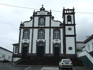
Around the 16th century, Achadinha was inhabited by 123 people in 43 homes. During this century, a small temple was constructed to the invocation of Nossa Senhora do Rosário (Our Lady of the Rosary), who was served by its first vicar Pêro Vieira. By the end of the 19th century, the small chapel was substituted by a three-nave church.
Achadinha, during the 17th century, was still little more than a small settlement, distant and isolated from the great centres, such as Vila Franca do Campo and Ponta Delgada. This was a land where isolation was commonplace, the winters strong and the people lived off of the land. Many of the inhabitants walked barefoot, wearing shabby rags, made of linen, in a region that was distant from any other centre.
In the first years of the 18th century, a medical surgeon named Dionísio Marcondes (born in Venice, Italy) married Maria Vieira, daughter of Manuel Váz Cogumbreiro on 6 December 1709.
It was in Achadinha that Liberal forces disembarked during the Liberal Wars, under the command of the General Count of Vila Flor.
Geography
Achadinha is located east of Ribeira Grande, along the northern coast of São Miguel, between its neighbours Salga in the west and Achada in the east. Located northeast of the island capital (Ponta Delgada) along the path of the Regional Roadway E.R.1-1ª, that encircles the island; it lies between the municipal seats of Nordeste and Ribeira Grande, with the central mountains towards the interior and the Atlantic Ocean to the north.
Economy
Remotely, the inhabitants of the parish dedicated their work to the cultivation of wheat, corn, beats and potato. The parish diversified its activities, but deviated little from its agriculture and animal husbandry, with the production of milk and beef cattle.