
Population (2014) 311 Local time Tuesday 6:45 PM | Area 77 km² | |
 | ||
Weather 1°C, Wind SW at 16 km/h, 89% Humidity Points of interest Bric Bouchet, Punta Ramiere, Col d'Urine | ||
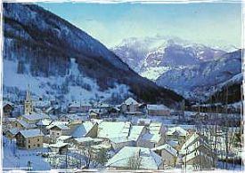
Abriès is a French commune in the Hautes-Alpes department in southeastern France.
Contents
Map of 05460 Abri%C3%A8s, France
It belongs to the Queyras Regional Park. It is located in the valley of the Guil and is appreciated for its position along long and medium distance footpaths in a rural and preserved environment. It also hosts a small ski resort.
Geography
The elevation of Abriès is between 1,513 and 3,305 meters, and before the second half of the 20th century, it was difficult to access because of its location in the end of the Guil valley. It has always has been a path between Italy and the southern Alps in France.
Population
Population 2012: source INSEE
References
Abriès Wikipedia(Text) CC BY-SA