
Airport type Public 17/35 4,000 | Owner City of Abernathy Elevation AMSL 3,327 ft / 1,014 m 4,000 1,219 | |
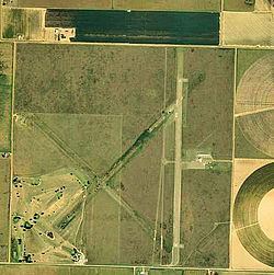 | ||
Abernathy Municipal Airport (FAA LID: F83) is a public use airport in Hale County, Texas, United States. It is owned by the City of Abernathy and located four nautical miles (5 mi, 7 km) east of its central business district.
Contents
History
The Abernathy Municipal Airport was built during World War II and opened in November 1943 as Abernathy Auxiliary Field by the United States Army Air Forces as an auxiliary field for nearby Lubbock Army Air Field and South Plains Army Air Field. The field was initially built for use by Lubbock Army Air Field, but following the activation of South Plains Army Air Field, was assigned to that base. In 1944 after the conclusion of training operations at South Plains Army Air Field, Abernathy reverted to Lubbock Army Air Field for the duration of the war. At the end of World War II, The United States military maintained over 5,600 bases stateside and around the world. The field was declared surplus and released to the War Assets Administration for disposal. The field was given to the City of Abernathy for use as a civil airport.
Facilities and aircraft
Abernathy Municipal Airport covers an area of 640 acres (259 ha) at an elevation of 3,327 feet (1,014 m) above mean sea level. It has one runway designated 17/35 with an asphalt surface measuring 4,000 by 75 feet (1,219 x 23 m). For the 12-month period ending June 25, 2009, the airport had 600 general aviation aircraft operations, an average of 50 per month.