
 | ||
Address Abandoned Pa Turnpike, Wells Tannery, PA 16691, USA | ||
Abandoned pennsylvania turnpike 2013 hd
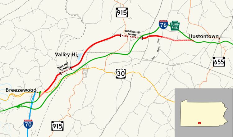
The Abandoned Pennsylvania Turnpike is the common name of a 13-mile (21 km) stretch of the Pennsylvania Turnpike that was bypassed in 1968 when a modern stretch opened to ease traffic congestion in the tunnels. In this case, the Sideling Hill Tunnel and Rays Hill Tunnel were bypassed, as was one of the Turnpike's travel plazas. The bypass is located just east of the heavily congested Breezewood interchange for Interstate 70 (I-70) eastbound at what is now I-76 exit 161.
Contents
Abandoned pennsylvania turnpike tunnels
Pre-abandonment
When the Pennsylvania Turnpike opened in 1940, it was known as the "Tunnel Highway" because it traversed seven tunnels: from east to west, Blue Mountain, Kittatinny Mountain, Tuscarora Mountain, Sideling Hill, Rays Hill, Allegheny Mountain, and Laurel Hill. There was one tunnel through each mountain, and the highway was reduced to a single lane in each direction through each tunnel. These tunnels were originally built as part of the South Pennsylvania Railroad. One short tunnel was bypassed during the original construction of the Turnpike.
By the late 1950s, the turnpike was so heavily used that traffic congestion demanded expansion. The Pennsylvania Turnpike Commission (PTC) conducted studies on either expanding or bypassing the tunnels. The result was the "twinning" of four tunnels (by constructing a second, parallel, two-lane tunnel), and outright bypass and closure of the other three. The tunnels through the Blue, Kittatinny, Tuscarora, and Allegheny mountains were expanded through the "twinning" process, while the other three were bypassed. The Laurel Hill Tunnel, located on the border of Westmoreland and Somerset counties, was one of these tunnels, though the bypass was only around two miles (3.2 km) long.
The Sideling Hill and Rays Hill tunnels, on the other hand, were near each other, and a 13-mile (21 km) bypass was built. As a result, the Cove Valley Travel Plaza, which was located between the eastern portal of the Sideling Hill Tunnel and the present-day turnpike, and serving the westbound direction, was bypassed. It was replaced with a new Sideling Hill Travel Plaza, which, unlike the plaza it replaced, is a single building serving travelers from both directions of the highway.
Post-abandonment
Today, the Abandoned Turnpike, as it is commonly known, is a popular tourist attraction. The PTC sold most of the property to the Southern Alleghenies Conservancy (SAC) for $1 in 2001. The property is managed by Friends of the Pike 2 Bike, a coalition of non-profit groups (including the SAC) to eventually convert the stretch into a bike trail. The property is officially closed to the public, and no motor vehicles are allowed on the property, but bicycle riders are free to use it at their own risk. The trail requires helmets and lights. Because this stretch sits on parts of the former right-of-way of the South Pennsylvania Railroad that was never completed but later formed the basis of the mainline turnpike, this makes the Pike2Bike unofficially a rail trail. The PTC still owns a stretch of about 0.25 miles (0.40 km) on the west and 3.5 miles (5.6 km) on the east for maintenance purposes.
The entrance ways to the tunnels were in respectable shape through the early 1980s, when vandalism and time began to take their toll; thieves stole the lettering of the signs of the tunnels sometime between 1981 and 1999. The tunnels themselves are still standing and, despite not having been maintained for decades, are still structurally sound.
A business plan and feasibility study was completed by Gannett Fleming in 2005. It proposed various ideas to make the trail as accessible as possible for cyclists, hikers, inline skaters, and equestrians.
As of November 2007, the trail is in the process of changing ownership to Bedford County. This is in response to the Pennsylvania Department of Conservation and Natural Resources' need for a governmental body to own the trail before it can give out grants. The Friends of the Pike 2 Bike will continue to run and oversee the trail.
Usage
In the early 1970s, the emission levels of unleaded gasoline were tested in Rays Hill Tunnel. A Plymouth Satellite was used as the test vehicle.
The PTC and PennDOT used the highway to train maintenance workers, as well as for testing of rumble strips.
There have also been numerous military uses for the highway; the tunnels were considered as a storage area for weapons, as was the open highway for aircraft. The military also used the highway for training soldiers for Iraq in the early 2000s, even after the highway was sold to the SAC.
The site of the former Cove Valley Travel Plaza was used as a shooting range for the Pennsylvania State Police. Since the SAC bought the property, the site has not been used as a shooting range, although warning signs are still posted in the area.
In 2008 the highway was used for the filming of the Dimension Films movie The Road starring Viggo Mortensen. The studios mildly restored the exterior of the eastern portal of the Ray's Hill Tunnel when it was used for filming.
Access
In 2005, the PTC restricted access to the abandoned turnpike by demolishing an overpass over U.S. Route 30 (US 30) in Breezewood and an overpass on Pump Station Road near the site of the old Cove Valley Travel Plaza. The demolition of the overpasses removed the liability and expense of repairing the aging bridges, marked the property lines between the public and the PTC-owned sections of the property, and prevented motorized vehicles from easily entering the abandoned turnpike.
The original plans for the removal included an access road, but somewhere along the way, it was removed and not known to Pike 2 Bike officials until it was too late. As of 2012, the Friends of the Pike 2 Bike are seeking to obtain grants that will allow the building of an access road and to rebuild on it the last remaining original toll booth, which was obtained in 2006. The toll booth will be used to collect a parking donation that will be used to pay for maintenance. An access road was built in the late 2000s on the PTC-owned side of the former Pump Station Road overpass, making the 3.5-mile (5.6 km) section still owned by the PTC a de facto access road to the active turnpike in itself; however, like other access roads along the turnpike, it is off-limits to the public and is only used by the PTC or Pennsylvania State Police.
There are three access points to the public section of the abandoned highway:
Other tunnel bypasses
The Abandoned Turnpike is perhaps the best-known of tunnel bypasses on toll roads. Among the other bypassed tunnels: