
Development status Active | ||
 | ||
Initial release December 2006; 10 years ago (2006-12) Stable release v2.0 / 4 May 2015; 21 months ago (2015-05-04) Repository github.com/GeoscienceAustralia/anuga_core | ||
ANUGA Hydro is a free and open source software tool for hydrodynamic modelling, suitable for predicting the consequences of hydrological disasters such as riverine flooding, storm surges and tsunamis. For example, ANUGA can be used to create predicted inundation maps based on hypothetical tsunami or flood scenarios. The ANUGA name without qualification is used informally to mean the ANUGA Hydro tool.
Contents
Background
Modelling the effects on the built environment of natural hazards such as riverine flooding, storm surges and tsunami is critical for understanding their economic and social impact on our urban communities. Geoscience Australia and the Australian National University have developed a freely available hydrodynamic inundation modelling tool called ANUGA to help simulate the impact of these hazards. Based on research conducted at the Australian National University in the nineties, the development of ANUGA was commenced at Geoscience Australia in 2004. Although the initial aim of ANUGA was a capability to model inundation from storm surge events, the focus was redirected to tsunami inundation in the wake of the 2004 Indian Ocean earthquake and tsunami. The first public open source release of ANUGA took place in December 2006. In 2007 after approaches from Local Government Engineers, a rainfall routine was added. This allows rainfall to be placed directly over the topography described in the computational domain. A time series can be applied to a polygon, or a series of polygons. Alternatively a rainfall grid can be applied. This is particularly useful for applying RADAR rainfall. ANUGA can model culverts and bridges with code from the open source Watershed Bounded Network Model (WBNM){Boyd,Rigby, VanDrie}, having a pipe, box and trapezoid routine. Development continues to create an arbitrary shape culvert solver and linking to a 1D piped network model such as SWMM. ANUGA is stable even in extreme flow with high Froude numbers. An example of this is the 1928 St Francis Dam Break in California that resulted in extreme flow velocities and complex waves in a tortuous valley. ANUGA ran this model with full volumetric mass balance preserved at all times and no instabilities any where in the model
Simulation engine
The fluid dynamics in ANUGA are based on a Finite volume method for solving the Shallow Water Wave Equation. This has been shown to be one of the most Stable, and Robust approaches to accurately resolve the behaviour of water movement. The study area is represented by a mesh of triangular cells that can vary in size in order to capture detail where it is required. By solving the governing equation within each cell, water surface, bed elevation (hence depth) and horizontal (X-y) momentum are tracked over time.
A major capability of ANUGA is that it can model the process of wetting and drying as water enters and leaves an area. This means that it is suitable for simulating water flow onto a beach or dry land and around structures such as buildings. ANUGA is also capable of modelling hydraulic jumps due to the ability of the finite-volume method to accommodate discontinuities in the solution. While ANUGA works with discontinuities in the conserved momentum quantities, it does not allow discontinuities in the bed elevation, although it remains stable and resolve the flow on quite steep slopes. Note that a discontinuous solver was recently added to the code (2014).
User Interface
Most ANUGA components are written in the object-oriented programming language Python. Software written in Python can be produced quickly and can be readily adapted to changing requirements throughout its lifetime. Computationally intensive components are written for efficiency in C routines working directly with Python numpy structures.
To set up a model of a scenario the user specifies the geometry (bathymetry and topography), the initial water level, boundary conditions such as tide, and any forcing terms that may drive the system such as rainfall, water abstraction, wind stress or atmospheric pressure gradients. Gravity and Frictional resistance from the different terrains in the model are represented by predefined forcing terms.
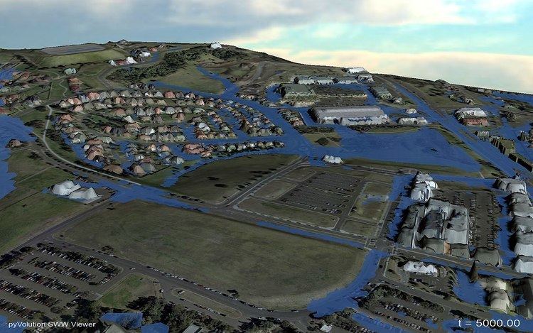
ANUGA viewer
The ANUGA Viewer is a graphical 3D rendering program suitable for animating the output files from ANUGA.
Additional viewing capability is available via several other options:
– Using Commercial Software such as WaterRide (Ref to WebSite)
– Using Free tools Such as Mirone (Grid viewing software) which has a specific tool called Aquamoto
– Using SWW2DEM in combination with any GIS platform
– Using Crayfish viewer as plugin in QGIS
– Possibly using tools such as VisIt (Ref to Web Site)
Validation studies
ANUGA has been extensively validated against wave tank experiments and field studies where available. Examples include validation against the wave tank experiment for the Okushiri 1995 tsunami, wave tank runup experiments at University of Queensland, the 2004 Indian Ocean tsunami impact at Patong Beach, comparison to other models, ANUGA was a late entry in the UK 2D model Benchmarking project in 2010 using version 1.1beta_7501. As a result, not all tests were completed. However of the basic tests ANUGA was well within the comparable range of results of other models. Since late 2013 the standard test suite for the model also includes a full catchment model (Towradgi Creek Catchment) which has been validated against the 17 August 1998 storm event.
ANUGA software development methodology
ANUGA is developed as an AGILE project so with strong adherence to Test Driven Development and Continuous Integration. ANUGA has almost 1000 individual tests that can be run by users or developers to verify that a given installation works as expected. ANUGA is fully versioned using the source code control system Subversion and has up till now been hosted at the Australian National University although the developers are considering moving ANUGA to Google Code or github to ensure sustainability in the longer term. The exact version number of a particular release is kept with the filename so that any installation can be linked back to a particular version in the repository. The use of this system allows a user to replicate a model run from a previous version, with the previous version at any time. It also of course thereby allows comparison with the current version.
ANUGA development timeline summary
Noting that ANUGA runs both in serial (1 core) and parallel (many cores) tested on 1000s.
Here is a rough time line of major developments:
Date : Version : Comment
1999 : ------- : Zoppou Roberts Paper
2004 : ------- : Storm Surge
2005 : ------- : Tsunami
2006/08/16: 3500 : Moved code to SVN
2006/09/07: 3548 : Offline viewer with Animation capability
2006/12/19: 4092 : First Public Release Open Source & Free
2007/06/04: 4530 : Rainfall forcing function added
2008/03/28: 5178 : Rainfall forcing to polygons
2008/06/10: 5435 : Bridges/ Culverts (using US Dept of Transportation Method as adapted by Generalised Equations by Boyd in the WBNM model)
2008/07/15: 5585 : Multi-Barrel culvert added
2009/08/14: 7376 : Moveable Bed (The bed elevation can be a time varying quantity)
2009/08/19: 7452 : Move culvert from Forcing to Operator
2010/11/11: 8069 : Major Version 1.2.0 package released
2010/11/25: 8087 : Minor Package up date 1.2.1 released
2011/01/31: 8116 : Update to Wind and Pressure Terms
2011/03/08: 8128 : Model domain Operators concept developed
2011/03/22: 8161 : Kinematic Viscosity moved from Forcing to Operator
2012/xx/xx: xxxx : Depth Varying Mannings Roughness Function added
2012/07/31: 8485 : Erosion Based on Bed Shear Operator
2013/05/27: 8877 : Add a gate structure capability
2013/09/12: 8973 : Set value by Grid(RADAR Rainfall & Roughness Grid)
2013/12/05: 0debdd6 : Added DE algorithms, well balanced and discontinuous elevation
2014/07/10: bf590e3 : Set up boundary flux integral operator
2014/08/05: af03985 : Reporting of mass conservation
2014/12/18: 1.2.5 : Moved package to GitHub
2015/02/07: 1.3.1 : Major change to directory structure
2015/03/19: 1.3.10 : Moved to GitHub.com//GeoscienceAustralia/anuga_core
2015/04/28: 1.3.11 : Updated manual and added validations_report to doc directory
2015/05/04: 2.0 : A major release where we moved to the DE0 algorithm (Discontinuous Elevation) as default algorithm
2016/06/28: 321cd1e : Added in erosion operator provided by Ted Rigby
ANUGA development ideas for the future
The development of ANUGA is ongoing and dynamic. The introduction of "Operators" was a major step in that it allowed many additional possibilities. The future development is currently driven by both performance increases and adding capability. Currently there is work underway on the following items (that will be moved to the above list once fully achieved):
– Easily availability to a GPU capable version ( Beta version is currently working)
– Linking to a highly capable urban pipe network model such as SWMM
– Ongoing speed improvements to the code
Limitations
Although a flexible hydrodynamic modelling tool, ANUGA has a number of limitations that any potential user needs to be aware of. They are:
Users
Use history
The model was found to have:
"The ability to construct a model with elements varying in size to suit the features being modelled permitted flow behaviour to be simulated realistically and at a level of local detail that structured grid models cannot practically reproduce"Awards and exposure
ANUGA has been used to understand tsunami risk to the Western Australia coastline and the results of this work are being utilised by emergency managers and the Department for Planning and Infrastructure in Western Australia. In 2007 this work received the Asia-Pacific Spatial Excellence Award and the Emergency Management Australia] Safer Communities Award. In June 2009, ANUGA was featured in a special episode on the Australian TV program The New Inventors: Dealing With Disasters.
Support and getting involved
ANUGA is an open source project and supported by the organizations that develop and use it. Questions and interest in contributing can be directed to the mailing list [email protected]
License
ANUGA is freely available and distributed under the terms of the GNU General Public Licence.