
Start date June 14, 2008 | Peak acceleration 4.36 g (vector sum) | |
 | ||
Magnitude Mj 7.2 (JMA scale), Mw 6.9 (by USGS) Depth 8 kilometres (5 mi) (JMA), 10 kilometres (6 mi) (USGS) Similar 2007 Chūetsu offshore e, 2004 Chūetsu earthquake, 2007 Noto earthquake, 2005 Fukuoka earthquake, Great Hanshin earthquake | ||
On June 14, the 2008 Iwate earthquake struck the Tōhoku region of northeastern Honshū in Japan. Japan Meteorological Agency (JMA) officially named this earthquake the Iwate–Miyagi Nairiku earthquake in 2008 (平成20年(2008年)岩手・宮城内陸地震).
Contents
- Intensity
- Tectonics
- Aftershocks
- Landslides
- Human casualties
- Electric power supply
- Expressways and railways
- References
This earthquake occurred in the south of the inland of Iwate Prefecture at 8:43 JST on June 14 (23:43 UTC on June 13). The JMA magnitude was estimated at Mj 7.2, and the moment magnitude by USGS was at Mw 6.9. The epicenter was located at 39°01.7′N 140°52.8′E, about 85 kilometres (55 mi) north of Sendai and about 385 kilometres (240 mi) north-northeast of Tokyo.
The strongest shaking was measured in the cities of Ōshū (Iwate) and Kurihara (Miyagi), both of which were measured as "strong 6" on the Japan Meteorological Agency seismic intensity scale, shindo (震度, shindo). Peak ground acceleration readings were high, with a maximum vector sum (3 component) value of 4,278 cm/s2 (4.36g).
Intensity
Seismic intensity (震度, Shindo) represents the strength of ground motion. JMA uses the scales of 0 to 7: 0, 1, 2, 3, 4, weak/strong 5, weak/strong 6, 7.
Tremors were felt across a large area.
Strongly shaken areas included:
Strong 6:
Iwate Pref. - City of Ōshū (奥州市).Miyagi Pref. - City of Kurihara (栗原市).Weak 6:
Iwate Pref. - City of Ōshū (奥州市).Miyagi Pref. - Cities of Kurihara (栗原市) and Ōsaki (大崎市).Strong 5:
Iwate Pref. - Cities of Ōshū (奥州市), Kitakami (北上市), Ichinoseki (一関市), Towns of Kanegasaki (金ケ崎町) and Hiraizumi (平泉町).Miyagi Pref. - Cities of Kurihara (栗原市), Ōsaki (大崎市), Sendai (仙台市), Tome (登米市), Natori (名取市), Towns of Misato (美里町), Wakuya (涌谷町), Kami (加美町), and Rifu (利府町).Akita Pref. - City of Yuzawa (湯沢市), and Village of Higashinaruse (東成瀬村).Tectonics
According to the USGS:
The Mw 6.8 Honshu earthquake of June 13th 2008 occurred in a region of convergence between the Pacific Plate and the Okhotsk section of the North American Plate in northern Japan, where the Pacific plate is moving west-northwest with respect to North America at a rate of approximately 8.3 cm/yr. The hypocenter of the earthquake indicates shallow thrusting motion in the upper (Okhotsk) plate, above the subducting Pacific plate, which lies at approximately 80 km depth at this location.
The earthquake occurred in a region of upper-plate contraction, probably within the complicated tectonics of the Ou Backbone Range, known to have hosted several large earthquakes in historic times. The largest of these events occurred in 1896, approximately 70km north of the June 13th event, and killed over 200 people in the local area.
Aftershocks
According to JMA:
Aftershocks of this earthquake were stronger than the Great Hanshin earthquake in 1995, but they happened much less frequently.
Over 200 aftershocks were observed in the first 24 hours, with about 400 in total over the first seven days. The largest ones (with Mj5.0 or greater) were
June 14, 9:20: Mj5.7: Max. seismic intensity reached Strong 5;June 14, 12:27: Mj5.2: Max. seismic intensity reached 4;June 16, 23:14: Mj5.3: Max. seismic intensity reached 4.From June 21 to July 1, four to 12 aftershocks were observed each day, with maximum seismic intensities of 3.
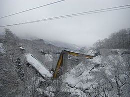
Landslides
Landslides triggered by this earthquake crushed structures, buried people, cut off access to certain roads, and isolated some rural communities. Mud from landslides dammed up rivers to form lakes called "quake lakes" (せき止め湖, sekitomeko).
By June 19, the Ministry of Land had identified fifteen quake lakes in Iwate and Miyagi prefectures, and work crews began draining three of them which were at high risk of overflow or breach from rain or aftershocks.
Human casualties
By 17:50 JST, June 25, twelve people were confirmed dead and 358 injured, and ten still missing.
Electric power supply
No nuclear power plants were shut down following this earthquake unlike the 2007 Chūetsu offshore earthquake quake. Some water was found to have splashed out of a reaction container in the Fukushima II Nuclear Power Plant possibly due to the tremor, but no radioactive material was released to the environment.
Expressways and railways
Expressways in Tōhoku region were closed in several sections, but all reopened by nighttime, barring traffic restrictions in one section for repair work.
Some train services by JR East were suspended on Shinkansen and local lines, and resumed on the following day from the first scheduled trains.
On Tōhoku Shinkansen, all running trains, about 20, were stopped by an earthquake detection system. Most were soon moved to the nearest stations. However, about 2,000 passengers were temporarily trapped inside three trains before being evacuated up to nine and a half hours later, because the trains were forced to stay in place while equipment inspections were carried out.
Suspensions on Tōhoku, Akita, Yamagata Shinkansen and delays on Jōetsu, Nagano Shinkansen reportedly involved 117,000 passengers. No trains derailed.