- Tree Kousa Dogwood Area 805 km² Local time Sunday 1:32 PM | Phone number 0228-22-1122 Population 70,379 (Feb 2015) | |
 | ||
- Flower Nikkōkisuge (Hemerocallis dumortieri var. esculenta) Weather 10°C, Wind NW at 18 km/h, 41% Humidity Points of interest Mt Kurikoma, Hosokuramain Park, Sakuradasan Shrine, Komanoyu Hot Spring, Kazenosawa Museum | ||
Lilly garden ichihazama kurihara miyagi japan
Kurihara (栗原市, Kurihara-shi) is a city located in Miyagi Prefecture, Japan. As of February 2015, the city had an estimated population of 70,379 and a population density of 87.4 persons per km². The total area was 804.97 km². Parts of the city are within the borders of the Kurikoma Quasi-National Park.
Contents
- Lilly garden ichihazama kurihara miyagi japan
- Map of Kurihara Miyagi Prefecture Japan
- Geography
- Climate
- Neighboring municipalities
- History
- Economy
- Railway
- National highways
- Local attractions
- Culture
- Festivals
- Noted people from Kurihara
- References
Map of Kurihara, Miyagi Prefecture, Japan
Geography
Kurihara covers the entire northwestern corner of Miyagi Prefecture. It is mostly rice farmland, and small mountain ridges, the largest of which cluster around Kurikoma-san, the tallest mountain in Kurihara, which is located at the furthest northwestern point of Miyagi Prefecture. In summer, the lotus petals on Lake Izunuma bloom. In fall Mt. Kurikoma is covered in fall colors and in winter migrating swans and geese come in flocks to spend the season on Kurihara's lakes.
Climate
The climate of Kurihara is classified as humid continental (Dfb) per the Köppen climate classification system. As with most of Japan, the summers in Kurihara are hot and humid with temperatures usually around 30 °C (86 °F). Summer is also typhoon season, however, since Kurihara is so far north and inland the area is rarely affected. Fall and spring are mild, with temperatures in the low to mid 20s (Celsius). In fall the days usually begin foggy and cold but clear up by midday. Spring comes late to the region and is mostly sunny punctuated with random light showers. The temperature fluctuates around freezing in winter, falling to an average low of −10 °C (14 °F), and snow levels vary with altitude.
Neighboring municipalities
History
The area of present-day Kurihara was part of ancient Mutsu Province, and has been settled since at least the Jomon period by the Emishi people. During the later portion of the Heian period, the area was ruled by the Northern Fujiwara. During the Sengoku period, the area was contested by various samurai clans before the area came under the control of the Date clan of Sendai Domain during the Edo period, under the Tokugawa shogunate.
During the Meiji period, many mines were dug in the mountains of Kurihara, and the Hosokura mine was Japan’s largest producer of lead and zinc. The mine closed in 1987.
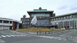
The modern city of Kurihara was established on April 1, 2005, from the merger of the towns of Ichihasama, Kannari, Kurikoma, Semine, Shiwahime, Takashimizu, Tsukidate, Uguisuzawa and Wakayanagi, and the village of Hanayama (all from Kurihara District). The new city hall is located in former Tsukidate. Although technically referred to as a "city", Kurihara in fact functions more like a county composed of ten separate towns.
Economy
The economy of Kurihara is largely based on agriculture.
Railway
National highways
Local attractions
Culture
Kurihara is known for its rice production. There are also a number of waterfalls, parks filled with cherry blossoms in spring, and flower gardens. These include: Abazu Gorge, Shiraito Falls, Gorindoyama Park, Hasama River Park, and Sanno Historic Park Iris Garden. It is also a renowned place for viewing the autumn leaves, especially around Mt. Kurikoma. Kurihara also has an abundance of hot spring resorts. These include: Yu-no-Kura Hot Spring, Yubama Hot Spring, Hanayama Hot Spring, and Nuruyu Hot Spring.
