
First system formed May 17, 2005 Total storms 15 | Last system dissipated October 20, 2005 Total depressions 17 Hurricanes 7 | |
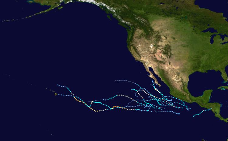 | ||
The 2005 Pacific hurricane season was a near average season that produce 17 depressions, 15 named storms, 7 hurricanes and 2 major hurricanes. The season officially begin on May 15, 2005 in the eastern Pacific and on June 1, 2005 in the central Pacific, and lasted until November 30, 2005. These dates conventionally delimit the period of each year when most tropical cyclones form in the northeastern Pacific Ocean. The season got off to a quick start, with the tropical depression that would become Hurricane Adrian forming just two days into the season on May 17. It took a very rare track skirting El Salvador as a Category 1 hurricane then striking Honduras as a tropical depression, where it killed seven. Between June and September, Dora was the only storm that posed a significant threat to land as it skirted the Mexican coast, and Kenneth came close to Hawaii as a dissipating tropical depression. Hurricane Otis appeared to be heading for an encounter with the Baja California peninsula, but turned north-northwest, paralleling the coast, before dissipating.
Contents
- Pre season forecasts
- Hurricane Adrian
- Tropical Storm Beatriz
- Tropical Storm Calvin
- Tropical Storm Dora
- Tropical Storm Eugene
- Tropical Depression One C
- Hurricane Fernanda
- Tropical Storm Greg
- Hurricane Hilary
- Tropical Storm Irwin
- Hurricane Jova
- Hurricane Kenneth
- Tropical Storm Lidia
- Hurricane Max
- Tropical Storm Norma
- Hurricane Otis
- Tropical Depression Sixteen E
- Storm names
- Season effects
- References
Pre-season forecasts
The U.S. National Oceanic and Atmospheric Administration predicted a slow year, with only a 10% chance of above-average storm activity in the eastern North Pacific and a 70% chance of below-normal activity. The pre-season forecast predicted 11 to 15 tropical storms, 6 to 8 hurricanes, and 2 to 4 major hurricanes (Category 3 or higher on the Saffir-Simpson Hurricane Scale).
The forecast for the central North Pacific was for a below-average season, with only two or three storms impacting the region, below the normal four to five.
Hurricane Adrian
In early May 2005, several areas of disturbed weather interacting with a weak tropical wave. This led to further development of convection around the storm. The low gradually became better organized and was determined to have become a tropical depression on the afternoon of May 17. An unusually strong mid to upper-level trough was situated over southwestern Mexico, leading to the depression traveling towards the northeast, rather than the usual northwest movement. The depression quickly intensified and became Tropical Storm Adrian later that day. Due to moderate southwesterly wind shear, Adrian only gradually intensified. By May 19, Adrian briefly intensified into a hurricane and peaked as an 80 mph (130 km/h) Category 1 hurricane shortly thereafter. Operationally, Adrian was assessed to have made landfall in El Salvador as a minimal hurricane. However, post season analysis indicated that Adrian rapidly weakened to a tropical depression before landfall near the Gulf of Fonseca in Honduras on May 20. The storm dissipated shortly after moving inland.
Since Adrian rapidly weakened before making landfall, there was minimal wind damage but heavy rainfall fell across much of El Salvador, Honduras, Nicaragua, and Guatemala leading to flooding. Damage totaled $12 million and seven fatalities was attributed to Adrian; a person drowned in floodwaters in Nicaragua.
Tropical Storm Beatriz
A tropical wave emerged off the western coast of Africa and uneventfully crossed the Atlantic, until reaching the Pacific basin on June 17. While near Mexico, the system interacted with and eventually absorbed several areas of disturbed weather. By late on June 21, it was determined that the wave had developed sufficient organization to be declared Tropical Depression Two-E while located 385 mi (620 km) south of Zihuatanejo. A large mid-level trough located over the Southern United States influenced the trajectory of the tropical cyclone, causing it to travel towards the west-northwest. The depression slowly intensified and was upgraded Tropical Storm Beatriz. Due to easterly wind shear and marginal sea surface temperatures, further development of the storm was minimal. Early on June 23, Beatriz peaked as a 50 mph (85 km/h) tropical storm.
After crossing the 78.8 °F (26 °C) isotherm – the lowest sea surface temperature required for a tropical cyclone to develop – Beatriz began to weaken. In addition, wind shear began displacing deep convection, which led forecasters at the National Hurricane Center to downgrade Beatriz to a tropical depression early on June 24. Due to the lack of convection around the center of the depression, it was determined to have degenerated into a remnant low-pressure area later that night. The remnant low later became detached from the mid and upper-level circulations, and took a slow turn to the southeast before dissipating on June 25.
Tropical Storm Calvin
Tropical Depression Three-E formed just south of Mexico early on June 26, and reached tropical storm strength and was named Calvin late that day. Tropical storm watches were issued for the southern coast of Mexico around Acapulco as Calvin slowly moved westward, with windspeeds peaking at 50 mph (80 km/h) on June 27, but all watches were cancelled on the morning of June 28 as it moved away from the coast. Calvin weakened to a tropical depression later that day, and lost tropical characteristics that night.
Tropical Storm Dora
An active early season continued with Tropical Depression Four-E forming on July 3 from a tropical wave south of the Mexican port of Acapulco, Guerrero. Watches and warnings were issued as it neared the Mexican coast. On the afternoon of July 4, the depression strengthened into a tropical storm while located about 45 miles (75 km) west-southwest of Acapulco. It came within miles of the coast, moving somewhat parallel to it on July 4, dropping heavy rainfall on the region. As it moved away from the coast, all watches were cancelled as it dropped to a tropical depression midday on July 5, finally dissipating early on July 6.
Tropical Storm Eugene
Eugene formed from a tropical disturbance off the central Mexican coast on July 18 and headed northwest, one of the few cyclones to reach tropical storm-strength without being designated as a tropical depression. Initially, as with most Eastern Pacific storms, no public advisories or warnings were issued, since it was heading out to sea. However, on July 19 it came within range of the southern tip of the Baja California peninsula. Tropical storm watches were issued for the area around Cabo San Lucas for most of the day, but the storm moved away without affecting land.
Tropical Depression One-C
The first tropical system in the central Pacific formed east-southeast of Hawaii on August 3, a month later than the first (and only) central system to develop in 2004. It began a track due west, which could have put it within range of the island of Oahu, Hawaii, a few days later. It was initially forecast to strengthen into a tropical storm (one had not formed in the central Pacific since Huko in the 2002 season). However, the next day's models changed to indicate no further increase in strength. Shortly after that, convection bursts ceased and the system lost its closed circulation while still 725 miles (1200 km) from Hilo.
As a tropical cyclone, Tropical Depression One-C had no impact on land. However, the remnants of the depression dropped moderate to heavy rainfall in Hawaii, particularly on the Island of Hawaii. Rainfall totals measured up to 8.8 in (223.5 mm) in Glenwood, Hawaii. Flash floods was reported in Kona and Ka‘ū, while minor flooding occurred in Hilo, Hamakua, and Kealakekua. In addition, minor street flooding was reported in several cities on that island; most notably, a nearly overflown drainage ditch threatened to submerge the Hawaii Belt Road.
Hurricane Fernanda
Tropical Depression Six-E formed from an area of disturbed weather some 690 miles (1100 km) south-southwest of Cabo San Lucas in the Mexican state of Baja California Sur on August 9. It was upgraded to Tropical Storm Fernanda late that day, and to Hurricane Fernanda on August 11, as it headed generally west-northwest into the open Pacific. On August 14 it dropped to tropical storm strength over cooler waters and on August 15 weakened to a tropical depression. It degenerated into a remnant low later in the day about 1,650 miles (2,660 km) southwest of the southern tip of the Baja California Peninsula.
Tropical Storm Greg
Tropical Depression Seven-E formed 670 miles (1100 km) south of Cabo San Lucas on August 11, and was upgraded to Tropical Storm Greg a few hours later. Although only 750 miles (1200 km) from Hurricane Fernanda it showed no signs of being pushed northwards by interaction, but set off westwards to follow Fernanda into the Pacific. Greg was downgraded to tropical depression status on August 14 and remained stationary throughout the day. It began drifting slowly westward early on August 15 and was destroyed by shear later in the day.
Hurricane Hilary
A tropical wave that is associated with the formation of Hillary, moved off Western Africa on August 4. The wave initially had a large area of deep convention, but the convention quickly diminished as the system moved across the eastern portion of the tropical Atlantic Ocean. The wave continued westward without much development or organization, and crossed northern South America and then entered the northern Pacific Ocean on August 17. Mid-level circulation and convention organized with the wave, as it was south of Guatemala on August 18. The system's organization persisted, but without defining a well-established center of circulation, at the surface. Tropical Depression Eight-E finally formed from the area of disturbed weather south of the Gulf of Tehuantepec, 140 miles (230 km) south of Puerto Angel, Mexico, on August 19. It strengthened to a tropical storm late that evening, and reached hurricane strength 24 hours later. Moving parallel to the Mexican coast and about 300 miles (480 km) off-shore, it reached Category 2 on the Saffir-Simpson Hurricane Scale late on August 21. Tropical storm winds affected the coast and a tropical storm warning was issued for a while. Hilary dissipated not long after weakening to a tropical storm on August 25.
Tropical Storm Irwin
Tropical Depression Nine-E formed in the Eastern Pacific southwest of the Mexican port of Manzanillo, Colima on August 25, out of a remnant wave that split from Atlantic Tropical Depression Ten (the other part of the wave would eventually develop into Hurricane Katrina) that crossed Central America. The depression strengthened to Tropical Storm Irwin early the next day, reaching wind speeds of 50 mph (85 km/h). Although Irwin headed almost due west over warm water, it encountered shear, soon weakened and dissipated on August 28.
Hurricane Jova
After two weeks of calm, Tropical Depression Ten-E formed late on September 11 well south-southwest of the Baja California Peninsula and headed almost due west. Late on September 14, the depression strengthened and was upgraded to tropical storm status. It strengthened further to hurricane status early on September 16. On September 18 it crossed meridian 140°W, becoming the first hurricane in about three years to be in the forecast area of the Central Pacific Hurricane Center. Jova soon strengthened to a major hurricane, the first one to exist in the Central Pacific since Ele in 2002. It weakened as it steered to the northeast of Hawai'i, weakening to a tropical storm on September 22 and to a tropical depression on September 23 before finally dissipating on September 24.
Hurricane Kenneth
An area of disturbed weather developed into Tropical Depression Eleven-E on September 14. Again, the depression was well south-southwest of the Baja California Peninsula when it formed just 600 miles (970 km) east of Depression Ten-E. It found more favorable conditions than its western neighbor, and was upgraded to Tropical Storm Kenneth just 12 hours after forming. Kenneth strengthened into a hurricane later that day and continued to strengthen very rapidly, becoming the first major hurricane of the season by reaching Category 3 on September 17. The storm became the strongest storm to form this season in the Eastern Pacific when Kenneth peaked with sustained winds of 135 mph (217 km/h), Category 4 on the Saffir Simpson Hurricane Scale. Kenneth began gradually weakening on September 19, and weakened to a tropical storm on September 20. However, Kenneth gained enough strength to be reclassified as a Category 1 hurricane on September 24, and very late on September 25 it crossed 140°W, making it the second hurricane of the season to enter the Central Pacific. It then dropped back again to a tropical storm, and weakened to a tropical depression on September 29 less than 400 miles (640 km) east of Hawai‘i. It came within 50 miles (80 km) of the Big Island of Hawaii before degenerating into an open wave. No tropical cyclone has made landfall on Hawai‘i since Tropical Depression Eugene in the 1993 season. 6–12 inches of rain was reported on portions of Hawaii.
Tropical Storm Lidia
The origins of Lidia was from one of several tropical waves that entered the eastern Pacific between September 10 and 15 in close succession. One of the waves became better organized as convection began to increase. The system was classified Tropical Depression Twelve-E early on September 17 about 760 mi (1,225 km) southwest of the southern tip of Baja California Sur. With a lack of major steering currents, the system moved slowly west-northwestward, and at the same time there was a developing tropical wave to its northeast. At that point, it was uncertain as to which system would become the dominant storm. By the afternoon of September 17, the depression was upgraded to Tropical Storm Lidia, based on satellite intensity estimates of 40 mph (65 km/h).
By the morning of September 18, Lidia had rapidly deteriorated and was beginning to merge with the larger system to its east. Only a few bursts of deep convection were associated with Lidia. Deep convection redeveloped later that morning and the intensity was operationally increased to 45 mph (75 km/h). However, post-season analysis indicated Lidia never intensified beyond winds of 40 mph (65 km/h). By late on September 19, Lidia was downgraded to a tropical depression as it was being absorbed into the circulation of newly developed Tropical Storm Max. Early the next morning, Lidia dissipated as it was absorbed by Max.
Hurricane Max
Tropical Depression Thirteen-E formed 500 miles (800 km) south-southeast of the tip of the Baja California Peninsula on September 18. It was sufficiently close to Lidia that it blew the earlier, weaker storm rapidly to the north. It strengthened to Tropical Storm Max within a few hours, and absorbed the remnants of Tropical Depression Lidia. On late September 19 the tropical storm was upgraded to Hurricane Max. The system began to weaken almost immediately thereafter, however, and Max dissipated in the early morning hours of September 22.
The merging of two tropical cyclones or the absorption of one tropical cyclone by another are uncommon events in the National Hurricane Center's area of responsibility. The last documented case of such an occurrence in the eastern North Pacific was when Hurricane Gil absorbed Tropical Storm Henriette in September 2001.
Tropical Storm Norma
On September 19, 2005, a large tropical disturbance formed south of Manzanillo, Colima. Tropical Depression Fourteen-E formed on 10:00 p.m September 21, while located about 402 miles (650 km) southwest of Manzanillo. Four hours later, it intensified into Tropical storm Norma. During that time, the storm's convection increased near its center.
On September 24, Norma continued to slowly move in a northwestward direction from 8:00 am to 2:00 pm PDT. Around mid-day some banding features also developed and the storm's center became more embedded within the convection; it reached a peak intensity of 55 mph (90 km/h). Easterly wind shear caused a decrease in the storm's organization later on September 24, generally weakening the convection. The center was then exposed from the convective activity by northwest winds early on September 25, and the storm's intensity was reduced. The sheared system began to gradually weaken as the center was located near the northeastern edge of poorly organized deep convection. Norma was downgraded to a tropical depression on September 26 at 1800 UTC.
Hurricane Otis
Tropical Depression Fifteen-E formed 497 miles (800 km) south-southwest of the Mexican port of Manzanillo, Colima, on September 28 out of an Atlantic wave that crossed into the Pacific (split off from what would become Hurricane Philippe in the Atlantic). Twenty four hours later it was upgraded to Tropical Storm Otis. Early on September 30 it was upgraded to a hurricane, and it reached Category 2 on October 1 with 105 mph (170 km/h) winds before weakening again as it drifted very slowly northwards. On October 2 it took a north-northwesterly turn, moving away from the Baja California peninsula, and instead paralleling the coast, before being downgraded to a depression. The NHC ceased advisories on Otis at 21:00 UTC the next day.
Although the center of Otis remained offshore, tropical storm-force winds were reported at higher elevations over portions of southern Baja California. At Cabo San Lucas, an automated weather station recorded a wind gust to 63 mph (101 km/h) on September 30, with sustained winds of 49 mph (79 km/h). There, periods of heavy rainfall mixed with fair skies as the storm passed. No damages or fatalities were reported, although some media reports indicated that the storm caused flooding in parts of the southern Baja California peninsula. Offshore, two ships reported tropical-storm-force winds in association with the storm: the Volendam on October 3, and the Star Harmonia on October 1.
Tropical Depression Sixteen-E
Tropical Depression Sixteen-E formed about 460 miles (740 km) south of the Mexican port of Acapulco, Guerrero, late on October 14. Although initial forecasts expected it to strengthen, the depression never gained enough organisation to become a tropical storm and instead appeared to dissipate. Advisories were discontinued on October 18, but resumed on October 19 when the remnant low pressure area regenerated deep convection. The system still struggled to develop, apparently due to the entrainment of relatively dry air inhibiting sustained convection. The second final advisory was issued at 2 pm PDT (2100 UTC) October 20. The remnant was absorbed into the Intertropical Convergence Zone (ITCZ) the next day.
Storm names
The following names were used for named storms that formed in the northeast Pacific in 2005. This is the same list that was used in the 1999 season. Names that were not assigned are marked in gray. There were no names retired by the WMO in the spring of 2006; therefore, the same list was reused in the 2011 season.
For storms that form in the Central Pacific Hurricane Center's area of responsibility, encompassing the area between 140 degrees west and the International Date Line, all names are used in a series of four rotating lists. The next four names that were slated for use in 2005 are shown below, however none of them were used.
Season effects
This is a table of all the storms that have formed in the 2005 Pacific hurricane season. It includes their duration, names, landfall(s), denoted in parentheses, damages, and death totals. Deaths in parentheses are additional and indirect (an example of an indirect death would be a traffic accident), but were still related to that storm. Damage and deaths include totals while the storm was extratropical, a wave, or a low, and all the damage figures are in 2005 USD.